Property Record
17535 Main St, Buchanan, VA 24066

Save to a Folder
{{folder.Name}}
{{folder.ListingIds.length}} Properties
{{folder.ListingIds.length}} Property
Create a New Folder
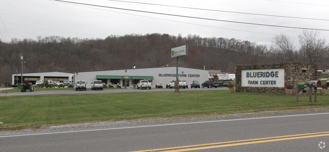
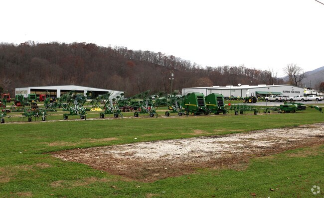
Property Detail
17535 Main St
64-82B
MT JOY
Commercialnec
Botetourt
T
Virginia
AE The base floodplain where base flood elevations are provided. AE Zones are now used on new format FIRMs instead of A1-A30 Zones.
8.89 AC
2025
Botetourt County
2026
Roanoke
040200
Roanoke, VA
NEARBY LISTINGS FOR SALE OR LEASE
-
-
View all Buchanan listings for sale on LoopNet.com
DEMOGRAPHICS near 17535 Main St
1 mile
3 mile
5 mile
2025 Total Population
375
2,278
3,803
2030 Population
373
2,261
3,799
Pop Growth 2025-2030
(0.53%)
(0.75%)
(0.11%)
Average Age
44
44
45
2025 Total Households
155
963
1,589
HH Growth 2025-2030
(0.65%)
(0.93%)
(0.25%)
Median Household Inc
$65,921
$62,987
$66,313
Avg Household Size
2.40
2.30
2.30
2025 Avg HH Vehicles
3.00
3.00
3.00
Median Home Value
$265,384
$234,309
$242,875
Median Year Built
1981
1976
1976
Nearby Places
Map Layers
Map Styles
 Street
 Aerial
Layers
 Traffic
 Biking
Places
Listings with unknown addresses are not visible on the map
- Restaurants
- Banks
- Shops
- Fitness
- Groceries
PUBLIC TRANSPORTATION
AIRPORT
Roanoke/Blacksburg Regional (Woodrum Field)
Drive
Walk
Distance
Roanoke/Blacksburg Regional (Woodrum Field)
31 min
22.5 mi
Freight Ports
Virginia Port Authority - Richmond
Drive
Walk
Distance
Virginia Port Authority - Richmond
191 min
168.2 mi
Nearby Properties
Address
Land Use
TOTAL SIZE
Lot Size
Zoning
Address
Land Use
TOTAL SIZE
Lot Size
Zoning
27.59 AC
A1
Address
Land Use
TOTAL SIZE
Lot Size
Zoning
20 AC
T
Address
Land Use
TOTAL SIZE
Lot Size
Zoning
2.83 AC
T
Address
Land Use
TOTAL SIZE
Lot Size
Zoning
34.71 AC
A1
Address
Land Use
TOTAL SIZE
Lot Size
Zoning
1.55 AC
4
Address
Land Use
TOTAL SIZE
Lot Size
Zoning
1,728 SF
347.72 AC
A1
Address
Land Use
TOTAL SIZE
Lot Size
Zoning
5.05 AC
B-2
Address
Land Use
TOTAL SIZE
Lot Size
Zoning
21.94 AC
A1
Address
Land Use
TOTAL SIZE
Lot Size
Zoning
310.98 AC
A1
Address
Land Use
TOTAL SIZE
Lot Size
Zoning
1.57 AC
RL
Address
Land Use
TOTAL SIZE
Lot Size
Zoning
4.65 AC
R-2
Address
Land Use
TOTAL SIZE
Lot Size
Zoning
1.59 AC
B-2
Address
Land Use
TOTAL SIZE
Lot Size
Zoning
0.67 AC
B-1
Address
Land Use
TOTAL SIZE
Lot Size
Zoning
0.73 AC
TR
Address
Land Use
TOTAL SIZE
Lot Size
Zoning
4.50 AC
T
Address
Land Use
TOTAL SIZE
Lot Size
Zoning
0.39 AC
RL
Address
Land Use
TOTAL SIZE
Lot Size
Zoning
9,270 SF
0.66 AC
4
Address
Land Use
TOTAL SIZE
Lot Size
Zoning
2.49 AC
T
Address
Land Use
TOTAL SIZE
Lot Size
Zoning
0.30 AC
O
Address
Land Use
TOTAL SIZE
Lot Size
Zoning
24.76 AC
T
Address
Land Use
TOTAL SIZE
Lot Size
Zoning
20.76 AC
B-1
Address
Land Use
TOTAL SIZE
Lot Size
Zoning
0.85 AC
T
Address
Land Use
TOTAL SIZE
Lot Size
Zoning
91.86 AC
A1
Address
Land Use
TOTAL SIZE
Lot Size
Zoning
180.50 AC
A1
Address
Land Use
TOTAL SIZE
Lot Size
Zoning
3.22 AC
Address
Land Use
TOTAL SIZE
Lot Size
Zoning
8,000 SF
0.98 AC
T
Address
Land Use
TOTAL SIZE
Lot Size
Zoning
149.50 AC
A1
Address
Land Use
TOTAL SIZE
Lot Size
Zoning
107.71 AC
A1
Address
Land Use
TOTAL SIZE
Lot Size
Zoning
11.77 AC
RL
The World's #1 Commercial Real Estate Marketplace
Connect with us
© 2026 CoStar Group
The information above has been obtained from sources believed reliable. While we do not doubt its accuracy we have not verified it and make no guarantee, warranty or representation about it. It is your responsibility to independently confirm its accuracy and completeness. Any projections, opinions, assumptions, or estimates used are for example only and do not represent the current or future performance of the property. The value of this transaction to you depends on tax and other factors which should be evaluated by your tax, financial, and legal advisors. You and your advisors should conduct a careful, independent investigation of the property to determine to your satisfaction the suitability of the property for your needs.