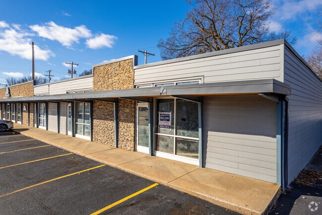
Property Record
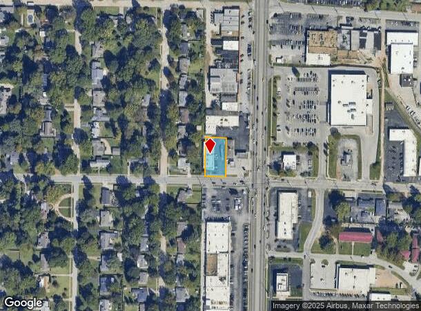
1755 E Bennett St, Springfield, MO 65804

NEARBY LISTINGS FOR SALE OR LEASE
Property Detail
1755 E Bennett St
12-30-122-012
BEG 120 FT W NW COR GLENSTONE & BENNETT N 175 FT W 93.7 FT S 175 FT E 93.7 FT TOBEG
Communitycenter
Greene
X
Missouri
29077C0334E
0.37 AC
2025
Northeast
2025
Springfield
001000
Springfield, MO
5,040 SF
DEMOGRAPHICS near 1755 E Bennett St
1 mile
3 mile
5 mile
2024 Total Population
9,918
91,538
177,435
2029 Population
10,231
95,171
184,359
Pop Growth 2024-2029
+ 3.16%
+ 3.97%
+ 3.90%
Average Age
38
37
39
2024 Total Households
5,055
41,502
79,382
HH Growth 2024-2029
+ 3.34%
+ 4.23%
+ 4.15%
Median Household Inc
$50,029
$43,937
$44,974
Avg Household Size
1.90
2.00
2.10
2024 Avg HH Vehicles
2.00
2.00
2.00
Median Home Value
$172,642
$161,403
$163,504
Median Year Built
1959
1972
1977
Nearby Places
Map Layers
Map Styles
 Street
 Aerial
Transit
 Traffic
 Biking
Places
Listings with unknown addresses are not visible on the map
- Restaurants
- Banks
- Shops
- Fitness
- Groceries
PUBLIC TRANSPORTATION
AIRPORT
Springfield-Branson Ntl
Drive
Walk
Distance
Springfield-Branson Ntl
28 min
15.4 mi
SALE & LEASE HISTORY
LISTING DATE
SALE/LEASE

Apr 21, 2017
For Lease
Nearby Properties
Address
Land Use
TOTAL SIZE
Lot Size
Zoning
Address
Land Use
TOTAL SIZE
Lot Size
Zoning
11.54 AC
Address
Land Use
TOTAL SIZE
Lot Size
Zoning
2,981,315 SF
76.43 AC
INC
Address
Land Use
TOTAL SIZE
Lot Size
Zoning
343,758 SF
29.81 AC
INC
Address
Land Use
TOTAL SIZE
Lot Size
Zoning
297,760 SF
4.22 AC
INC
Address
Land Use
TOTAL SIZE
Lot Size
Zoning
299,725 SF
18.80 AC
INC
Address
Land Use
TOTAL SIZE
Lot Size
Zoning
233,445 SF
8.17 AC
INC
Address
Land Use
TOTAL SIZE
Lot Size
Zoning
376,072 SF
17.67 AC
INC
Address
Land Use
TOTAL SIZE
Lot Size
Zoning
12.74 AC
Address
Land Use
TOTAL SIZE
Lot Size
Zoning
210,374 SF
24.37 AC
INC
Address
Land Use
TOTAL SIZE
Lot Size
Zoning
12.35 AC
INC
Address
Land Use
TOTAL SIZE
Lot Size
Zoning
779,221 SF
45.03 AC
INC
Address
Land Use
TOTAL SIZE
Lot Size
Zoning
2.31 AC
INC
Address
Land Use
TOTAL SIZE
Lot Size
Zoning
18.35 AC
Address
Land Use
TOTAL SIZE
Lot Size
Zoning
224,730 SF
19.99 AC
INC
Address
Land Use
TOTAL SIZE
Lot Size
Zoning
355,759 SF
2.23 AC
INC
Address
Land Use
TOTAL SIZE
Lot Size
Zoning
2.76 AC
INC.
Address
Land Use
TOTAL SIZE
Lot Size
Zoning
10.29 AC
INC.
Address
Land Use
TOTAL SIZE
Lot Size
Zoning
13.88 AC
INC
Address
Land Use
TOTAL SIZE
Lot Size
Zoning
51.65 AC
INC
Address
Land Use
TOTAL SIZE
Lot Size
Zoning
211,041 SF
19.13 AC
INC
Address
Land Use
TOTAL SIZE
Lot Size
Zoning
25.51 AC
INC
Address
Land Use
TOTAL SIZE
Lot Size
Zoning
4.63 AC
O-2
Address
Land Use
TOTAL SIZE
Lot Size
Zoning
253,781 SF
9.65 AC
INC
Address
Land Use
TOTAL SIZE
Lot Size
Zoning
1.99 AC
INC
Address
Land Use
TOTAL SIZE
Lot Size
Zoning
108,153 SF
7.37 AC
INC.
Address
Land Use
TOTAL SIZE
Lot Size
Zoning
8.24 AC
INC
Address
Land Use
TOTAL SIZE
Lot Size
Zoning
324,341 SF
43 AC
INC
Address
Land Use
TOTAL SIZE
Lot Size
Zoning
16.73 AC
Address
Land Use
TOTAL SIZE
Lot Size
Zoning
16.41 AC
INC
Address
Land Use
TOTAL SIZE
Lot Size
Zoning
116,085 SF
3.45 AC
INC
The World's #1 Commercial Real Estate Marketplace
Connect with us
© 2026 CoStar Group
The information above has been obtained from sources believed reliable. While we do not doubt its accuracy we have not verified it and make no guarantee, warranty or representation about it. It is your responsibility to independently confirm its accuracy and completeness. Any projections, opinions, assumptions, or estimates used are for example only and do not represent the current or future performance of the property. The value of this transaction to you depends on tax and other factors which should be evaluated by your tax, financial, and legal advisors. You and your advisors should conduct a careful, independent investigation of the property to determine to your satisfaction the suitability of the property for your needs.