Property Record
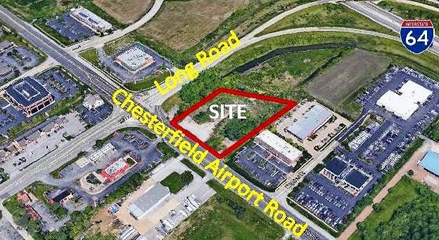
17551 Chesterfield Airport Rd, Chesterfield, MO 63005
NEARBY LISTINGS FOR SALE OR LEASE
-
-
Long Road Crossing Dr & N Trade Center
Chesterfield, MO 63005
$464,286 - $12,869,337
0.82 - 10.86 AC Lot
Land
-
-
-
View all Chesterfield listings for sale on LoopNet.com
Property Detail
17551 Chesterfield Airport Rd
St. Louis, MO-IL
John L Long Estate
17U-14-0203
JOHN L LONG ESTATE LOT PT 5
Vacantlandnec
St. Louis
X
Missouri
29183C0465G
5
2024
0.44 AC
2025
Chesterfield/Hwy-40
221629
St. Louis
DEMOGRAPHICS near 17551 Chesterfield Airport Rd
1 Mile
3 Mile
5 Mile
2024 Total Population
843
15,764
79,305
2029 Population
847
15,618
79,836
Pop Growth 2024-2029
+ 0.47%
(0.93%)
+ 0.67%
Average Age
41
42
43
2024 Total Households
278
5,945
29,808
HH Growth 2024-2029
+ 0.36%
(0.86%)
+ 0.68%
Median Household Inc
$173,809
$164,581
$131,248
Avg Household Size
3.00
2.60
2.60
2024 Avg HH Vehicles
2.00
2.00
2.00
Median Home Value
$566,116
$646,673
$395,125
Median Year Built
1996
1993
1987
Nearby Places
Map Layers
Map Styles
 Street
 Aerial
- Restaurants
- Banks
- Shops
- Fitness
- Groceries
PUBLIC TRANSPORTATION
AIRPORT
St Louis Lambert International
DRIVE
WALK
Distance
St Louis Lambert International
35 min
26.0 mi
SALE & LEASE HISTORY
LISTING DATE
SALE/LEASE

Sep 24, 2016
For Sale
Dec 19, 2018
For Sale
Dec 19, 2018
For Sale
Apr 13, 2017
For Lease
Apr 07, 2021
For Sale
Nearby Properties
Address
Land Use
TOTAL SIZE
Lot Size
Zoning
Address
Land Use
TOTAL SIZE
Lot Size
Zoning
8.21 AC
105C8
Address
Land Use
TOTAL SIZE
Lot Size
Zoning
420,140 SF
16.49 AC
105C8
Address
Land Use
TOTAL SIZE
Lot Size
Zoning
462,876 SF
12.89 AC
105R8
Address
Land Use
TOTAL SIZE
Lot Size
Zoning
Address
Land Use
TOTAL SIZE
Lot Size
Zoning
Address
Land Use
TOTAL SIZE
Lot Size
Zoning
351,496 SF
31.73 AC
NU
Address
Land Use
TOTAL SIZE
Lot Size
Zoning
269,687 SF
38.30 AC
105C8
Address
Land Use
TOTAL SIZE
Lot Size
Zoning
218,130 SF
7.31 AC
105PC&R
Address
Land Use
TOTAL SIZE
Lot Size
Zoning
363,584 SF
48.15 AC
FPNU
Address
Land Use
TOTAL SIZE
Lot Size
Zoning
344,386 SF
41.26 AC
R2
Address
Land Use
TOTAL SIZE
Lot Size
Zoning
359,937 SF
26.91 AC
R4
Address
Land Use
TOTAL SIZE
Lot Size
Zoning
242,380 SF
12.60 AC
105PC&R
Address
Land Use
TOTAL SIZE
Lot Size
Zoning
288,733 SF
36.80 AC
R5
Address
Land Use
TOTAL SIZE
Lot Size
Zoning
285,752 SF
23.98 AC
105PC
Address
Land Use
TOTAL SIZE
Lot Size
Zoning
197,927 SF
16.61 AC
105C8
Address
Land Use
TOTAL SIZE
Lot Size
Zoning
204,940 SF
16.35 AC
FPNU
Address
Land Use
TOTAL SIZE
Lot Size
Zoning
2,164 SF
22.98 AC
105PS
Address
Land Use
TOTAL SIZE
Lot Size
Zoning
58,710 SF
14.75 AC
105PC
Address
Land Use
TOTAL SIZE
Lot Size
Zoning
117,704 SF
9.27 AC
105PI
Address
Land Use
TOTAL SIZE
Lot Size
Zoning
150,788 SF
4.91 AC
105C8
Address
Land Use
TOTAL SIZE
Lot Size
Zoning
7,860 SF
223.24 AC
105M3
Address
Land Use
TOTAL SIZE
Lot Size
Zoning
84,818 SF
10.11 AC
105M3
Address
Land Use
TOTAL SIZE
Lot Size
Zoning
185.56 AC
105FPNU
Address
Land Use
TOTAL SIZE
Lot Size
Zoning
121,583 SF
3.20 AC
105C8
Address
Land Use
TOTAL SIZE
Lot Size
Zoning
6.64 AC
105PC
Address
Land Use
TOTAL SIZE
Lot Size
Zoning
8.15 AC
105PI
Address
Land Use
TOTAL SIZE
Lot Size
Zoning
97,024 SF
4.65 AC
105C8
Address
Land Use
TOTAL SIZE
Lot Size
Zoning
89,616 SF
9.07 AC
M3
Address
Land Use
TOTAL SIZE
Lot Size
Zoning
64,172 SF
4.91 AC
105C8
Address
Land Use
TOTAL SIZE
Lot Size
Zoning
74,783 SF
14.31 AC
105M3
The World's #1 Commercial Real Estate Marketplace
Connect with us
© 2026 CoStar Group
The information above has been obtained from sources believed reliable. While we do not doubt its accuracy we have not verified it and make no guarantee, warranty or representation about it. It is your responsibility to independently confirm its accuracy and completeness. Any projections, opinions, assumptions, or estimates used are for example only and do not represent the current or future performance of the property. The value of this transaction to you depends on tax and other factors which should be evaluated by your tax, financial, and legal advisors. You and your advisors should conduct a careful, independent investigation of the property to determine to your satisfaction the suitability of the property for your needs.