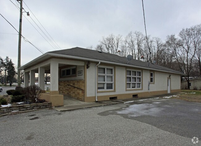
Property Record
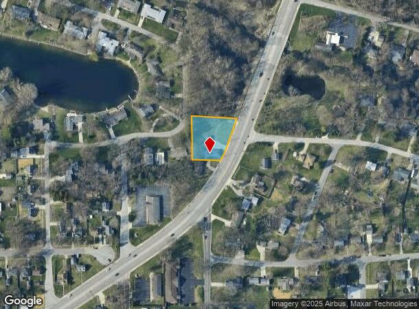
17561 State Road 23 Rd, South Bend, IN 46635
NEARBY LISTINGS FOR SALE OR LEASE
Property Detail
17561 State Road 23 Rd
71-04-32-202-002.000-003
Wilmette Park 2Nd Add
Storebuilding
TR W OF EDWARDSBURG HWY E & ADJ TO WILMETTE PARK 2ND ADD EX STRIP SOLD E END & ADJ TO HWY SEC 32-38-3E
X
St Joseph
18141C0204D
Indiana
2023
0.70 AC
2024
Outlying St Joseph County
011309
South Bend/Mishawaka
3,000 SF
South Bend-Mishawaka, IN-MI
DEMOGRAPHICS near 17561 State Road 23 Rd
1 Mile
3 Mile
5 Mile
2024 Total Population
9,899
79,452
178,872
2029 Population
9,896
79,507
179,198
Pop Growth 2024-2029
(0.03%)
+ 0.07%
+ 0.18%
Average Age
38
38
38
2024 Total Households
4,597
32,187
70,648
HH Growth 2024-2029
+ 0.11%
+ 0.15%
+ 0.18%
Median Household Inc
$43,623
$58,067
$55,322
Avg Household Size
2.00
2.10
2.30
2024 Avg HH Vehicles
1.00
2.00
2.00
Median Home Value
$141,810
$172,045
$153,678
Median Year Built
1975
1970
1965
Nearby Places
Map Layers
Map Styles
 Street
 Aerial
- Restaurants
- Banks
- Shops
- Fitness
- Groceries
PUBLIC TRANSPORTATION
AIRPORT
South Bend International
DRIVE
WALK
Distance
South Bend International
17 min
8.0 mi
Freight Ports
Port of Baltimore
DRIVE
WALK
Distance
Port of Baltimore
1 min
532.1 mi
SALE & LEASE HISTORY
LISTING DATE
SALE/LEASE

Aug 17, 2017
For Sale
Nearby Properties
Address
Land Use
TOTAL SIZE
Lot Size
Zoning
Address
Land Use
TOTAL SIZE
Lot Size
Zoning
3,879,729 SF
436.76 AC
Address
Land Use
TOTAL SIZE
Lot Size
Zoning
685,709 SF
44 SF
Address
Land Use
TOTAL SIZE
Lot Size
Zoning
560,184 SF
0.01 AC
Address
Land Use
TOTAL SIZE
Lot Size
Zoning
808,463 SF
30.51 AC
Address
Land Use
TOTAL SIZE
Lot Size
Zoning
24,392 SF
48.07 AC
Address
Land Use
TOTAL SIZE
Lot Size
Zoning
966,201 SF
0.01 AC
Address
Land Use
TOTAL SIZE
Lot Size
Zoning
294,502 SF
87 SF
Address
Land Use
TOTAL SIZE
Lot Size
Zoning
291,729 SF
0.79 AC
Address
Land Use
TOTAL SIZE
Lot Size
Zoning
369,116 SF
19.80 AC
Address
Land Use
TOTAL SIZE
Lot Size
Zoning
168,997 SF
9.62 AC
Address
Land Use
TOTAL SIZE
Lot Size
Zoning
529,154 SF
131 SF
Address
Land Use
TOTAL SIZE
Lot Size
Zoning
275,670 SF
44 SF
Address
Land Use
TOTAL SIZE
Lot Size
Zoning
262,392 SF
Address
Land Use
TOTAL SIZE
Lot Size
Zoning
599,502 SF
39.10 AC
Address
Land Use
TOTAL SIZE
Lot Size
Zoning
394,459 SF
44 SF
Address
Land Use
TOTAL SIZE
Lot Size
Zoning
538,338 SF
0.01 AC
Address
Land Use
TOTAL SIZE
Lot Size
Zoning
160,546 SF
Address
Land Use
TOTAL SIZE
Lot Size
Zoning
319,715 SF
2.57 AC
Address
Land Use
TOTAL SIZE
Lot Size
Zoning
66,297 SF
131 SF
Address
Land Use
TOTAL SIZE
Lot Size
Zoning
151,377 SF
0.01 AC
Address
Land Use
TOTAL SIZE
Lot Size
Zoning
239,419 SF
44 SF
Address
Land Use
TOTAL SIZE
Lot Size
Zoning
206,651 SF
1.68 AC
Address
Land Use
TOTAL SIZE
Lot Size
Zoning
770,407 SF
0.01 AC
Address
Land Use
TOTAL SIZE
Lot Size
Zoning
220,913 SF
29.14 AC
Address
Land Use
TOTAL SIZE
Lot Size
Zoning
393,123 SF
2.91 AC
Address
Land Use
TOTAL SIZE
Lot Size
Zoning
18,028 SF
80.67 AC
Address
Land Use
TOTAL SIZE
Lot Size
Zoning
186,131 SF
87 SF
Address
Land Use
TOTAL SIZE
Lot Size
Zoning
207,846 SF
2.33 AC
Address
Land Use
TOTAL SIZE
Lot Size
Zoning
799,664 SF
0.01 AC
Address
Land Use
TOTAL SIZE
Lot Size
Zoning
331,913 SF
30 AC
The World's #1 Commercial Real Estate Marketplace
Connect with us
© 2025 CoStar Group
The information above has been obtained from sources believed reliable. While we do not doubt its accuracy we have not verified it and make no guarantee, warranty or representation about it. It is your responsibility to independently confirm its accuracy and completeness. Any projections, opinions, assumptions, or estimates used are for example only and do not represent the current or future performance of the property. The value of this transaction to you depends on tax and other factors which should be evaluated by your tax, financial, and legal advisors. You and your advisors should conduct a careful, independent investigation of the property to determine to your satisfaction the suitability of the property for your needs.