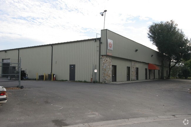
Property Record
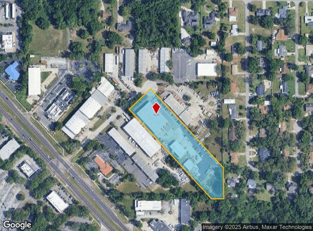
1757 Benbow Ct, Apopka, FL 32703
NEARBY LISTINGS FOR SALE OR LEASE
Property Detail
1757 Benbow Ct
Orlando-Kissimmee-Sanford, FL
North 441 Indus Park
24-2128-5986-00-032
NORTH 441 INDUSTRIAL PARK 10/61 BEG SE COR OF LOT 3 RUN W 80 .52 FT N 43 DEG W 815.62 FT N 46 DEG E 200 FT S 43 DEG E 717 .44 FT S 208.33 FT TO POB
Warehouse
Orange
X
Florida
12095C0140F
3
2024
3.71 AC
2025
NW Orange County
017503
Orlando
38,040 SF
DEMOGRAPHICS near 1757 Benbow Ct
1 mile
3 mile
5 mile
2024 Total Population
5,130
77,994
228,481
2029 Population
5,258
80,250
236,158
Pop Growth 2024-2029
+ 2.50%
+ 2.89%
+ 3.36%
Average Age
41
40
39
2024 Total Households
1,784
28,485
84,534
HH Growth 2024-2029
+ 2.47%
+ 2.96%
+ 3.48%
Median Household Inc
$62,805
$60,747
$59,326
Avg Household Size
2.80
2.70
2.60
2024 Avg HH Vehicles
2.00
2.00
2.00
Median Home Value
$271,583
$277,249
$278,280
Median Year Built
1990
1987
1986
Nearby Places
Map Layers
Map Styles
 Street
 Aerial
Transit
 Traffic
 Biking
Places
Listings with unknown addresses are not visible on the map
- Restaurants
- Banks
- Shops
- Fitness
- Groceries
PUBLIC TRANSPORTATION
AIRPORT
Orlando International
Drive
Walk
Distance
Orlando International
38 min
23.1 mi
Orlando Sanford International
Drive
Walk
Distance
Orlando Sanford International
39 min
23.9 mi
Nearby Properties
Address
Land Use
TOTAL SIZE
Lot Size
Zoning
Address
Land Use
TOTAL SIZE
Lot Size
Zoning
745,187 SF
18 AC
PUD
Address
Land Use
TOTAL SIZE
Lot Size
Zoning
630,861 SF
31.68 AC
PUDMO
Address
Land Use
TOTAL SIZE
Lot Size
Zoning
1,674 SF
10.53 AC
R3
Address
Land Use
TOTAL SIZE
Lot Size
Zoning
384,447 SF
10.70 AC
P-D
Address
Land Use
TOTAL SIZE
Lot Size
Zoning
373,462 SF
53.53 AC
IND-4
Address
Land Use
TOTAL SIZE
Lot Size
Zoning
269,555 SF
214.60 AC
PUD
Address
Land Use
TOTAL SIZE
Lot Size
Zoning
269,919 SF
24.44 AC
R-3
Address
Land Use
TOTAL SIZE
Lot Size
Zoning
5,913 SF
14.46 AC
Address
Land Use
TOTAL SIZE
Lot Size
Zoning
257,471 SF
38.42 AC
C-C
Address
Land Use
TOTAL SIZE
Lot Size
Zoning
268,195 SF
50.24 AC
O
Address
Land Use
TOTAL SIZE
Lot Size
Zoning
249,311 SF
21.11 AC
R3A
Address
Land Use
TOTAL SIZE
Lot Size
Zoning
497,045 SF
22.03 AC
RMF
Address
Land Use
TOTAL SIZE
Lot Size
Zoning
220,883 SF
53.87 AC
IND-4
Address
Land Use
TOTAL SIZE
Lot Size
Zoning
271,076 SF
19.31 AC
PUD
Address
Land Use
TOTAL SIZE
Lot Size
Zoning
375,987 SF
15.56 AC
I-L
Address
Land Use
TOTAL SIZE
Lot Size
Zoning
1,768 SF
20.77 AC
PUDMO
Address
Land Use
TOTAL SIZE
Lot Size
Zoning
342,011 SF
21.15 AC
I-L
Address
Land Use
TOTAL SIZE
Lot Size
Zoning
179,970 SF
39.95 AC
A-1
Address
Land Use
TOTAL SIZE
Lot Size
Zoning
162,978 SF
17.06 AC
PUDMO
Address
Land Use
TOTAL SIZE
Lot Size
Zoning
185,190 SF
12.82 AC
C-C
Address
Land Use
TOTAL SIZE
Lot Size
Zoning
154,065 SF
15.27 AC
MOC1
Address
Land Use
TOTAL SIZE
Lot Size
Zoning
163,963 SF
17.16 AC
IND-1/IND-
Address
Land Use
TOTAL SIZE
Lot Size
Zoning
149,832 SF
24.59 AC
IND-2/IND-
Address
Land Use
TOTAL SIZE
Lot Size
Zoning
59,519 SF
4.46 AC
PUDMO
Address
Land Use
TOTAL SIZE
Lot Size
Zoning
117,335 SF
13.63 AC
PUD
Address
Land Use
TOTAL SIZE
Lot Size
Zoning
335,585 SF
3.20 AC
P-D
Address
Land Use
TOTAL SIZE
Lot Size
Zoning
242,916 SF
25.88 AC
C-C
Address
Land Use
TOTAL SIZE
Lot Size
Zoning
61,427 SF
57.66 AC
IND-2/IND-
Address
Land Use
TOTAL SIZE
Lot Size
Zoning
111,615 SF
25.92 AC
RTF
Address
Land Use
TOTAL SIZE
Lot Size
Zoning
182,347 SF
19.38 AC
IN
The World's #1 Commercial Real Estate Marketplace
Connect with us
© 2026 CoStar Group
The information above has been obtained from sources believed reliable. While we do not doubt its accuracy we have not verified it and make no guarantee, warranty or representation about it. It is your responsibility to independently confirm its accuracy and completeness. Any projections, opinions, assumptions, or estimates used are for example only and do not represent the current or future performance of the property. The value of this transaction to you depends on tax and other factors which should be evaluated by your tax, financial, and legal advisors. You and your advisors should conduct a careful, independent investigation of the property to determine to your satisfaction the suitability of the property for your needs.