Property Record
1758 Anthony Rd, Burlington, NC 27215


NEARBY LISTINGS FOR SALE OR LEASE
Property Detail
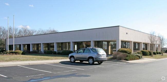
1758 Anthony Rd
Burlington, NC
Splawn Assoc
120369
BA ANTHONY RD LT 1 12-5C-18
Manufacturinglight
Alamance
X
North Carolina
3710886300K
1
2025
6.73 AC
2025
SW Alamance County
020801
Greensboro/Winston-Salem
41,312 SF
DEMOGRAPHICS near 1758 Anthony Rd
1 mile
3 mile
5 mile
2024 Total Population
802
32,164
93,834
2029 Population
866
34,637
101,515
Pop Growth 2024-2029
+ 7.98%
+ 7.69%
+ 8.19%
Average Age
39
41
40
2024 Total Households
331
13,656
38,194
HH Growth 2024-2029
+ 8.16%
+ 7.82%
+ 8.39%
Median Household Inc
$60,652
$53,821
$53,402
Avg Household Size
2.40
2.30
2.30
2024 Avg HH Vehicles
2.00
2.00
2.00
Median Home Value
$162,389
$181,359
$191,978
Median Year Built
1976
1979
1981
Nearby Places
Map Layers
Map Styles
 Street
 Aerial
Transit
 Traffic
 Biking
Places
Listings with unknown addresses are not visible on the map
- Restaurants
- Banks
- Shops
- Fitness
- Groceries
PUBLIC TRANSPORTATION
COMMUTER RAIL
Burlington Station (Piedmont - North Carolina by Train (NC Train))
Drive
Walk
Distance
Burlington Station (Piedmont - North Carolina by Train (NC Train))
8 min
4.1 mi
AIRPORT
Piedmont Triad International
Drive
Walk
Distance
Piedmont Triad International
49 min
33.5 mi
Nearby Properties
Address
Land Use
TOTAL SIZE
Lot Size
Zoning
Address
Land Use
TOTAL SIZE
Lot Size
Zoning
350,000 SF
64.18 AC
O I
Address
Land Use
TOTAL SIZE
Lot Size
Zoning
2,315 SF
55.43 AC
I 1
Address
Land Use
TOTAL SIZE
Lot Size
Zoning
41,892 SF
21.63 AC
CR
Address
Land Use
TOTAL SIZE
Lot Size
Zoning
10,744 SF
24.60 AC
MF A
Address
Land Use
TOTAL SIZE
Lot Size
Zoning
12,600 SF
44.61 AC
Address
Land Use
TOTAL SIZE
Lot Size
Zoning
84,881 SF
52.87 AC
I1
Address
Land Use
TOTAL SIZE
Lot Size
Zoning
10,384 SF
16.51 AC
B2
Address
Land Use
TOTAL SIZE
Lot Size
Zoning
53,012 SF
18.58 AC
B 2
Address
Land Use
TOTAL SIZE
Lot Size
Zoning
90,767 SF
36.47 AC
I 1
Address
Land Use
TOTAL SIZE
Lot Size
Zoning
714,245 SF
109.43 AC
I 1
Address
Land Use
TOTAL SIZE
Lot Size
Zoning
80,865 SF
76.02 AC
I 1A
Address
Land Use
TOTAL SIZE
Lot Size
Zoning
9,672 SF
10.77 AC
MF A
Address
Land Use
TOTAL SIZE
Lot Size
Zoning
43,680 SF
5.77 AC
Address
Land Use
TOTAL SIZE
Lot Size
Zoning
23,992 SF
25.66 AC
R 9
Address
Land Use
TOTAL SIZE
Lot Size
Zoning
370,000 SF
24.09 AC
B 2
Address
Land Use
TOTAL SIZE
Lot Size
Zoning
19,872 SF
9.80 AC
Address
Land Use
TOTAL SIZE
Lot Size
Zoning
31,585 SF
18.69 AC
MF A
Address
Land Use
TOTAL SIZE
Lot Size
Zoning
40,440 SF
23.57 AC
R 9
Address
Land Use
TOTAL SIZE
Lot Size
Zoning
55,500 SF
Address
Land Use
TOTAL SIZE
Lot Size
Zoning
101,469 SF
4.28 AC
CR
Address
Land Use
TOTAL SIZE
Lot Size
Zoning
73,948 SF
Address
Land Use
TOTAL SIZE
Lot Size
Zoning
7,456 SF
346.75 AC
Address
Land Use
TOTAL SIZE
Lot Size
Zoning
47,520 SF
1.44 AC
B 2
Address
Land Use
TOTAL SIZE
Lot Size
Zoning
59,904 SF
9.11 AC
B 2
Address
Land Use
TOTAL SIZE
Lot Size
Zoning
64,926 SF
4.62 AC
O I
Address
Land Use
TOTAL SIZE
Lot Size
Zoning
17,073 SF
7.59 AC
R 9
Address
Land Use
TOTAL SIZE
Lot Size
Zoning
15,512 SF
6.54 AC
MF A
Address
Land Use
TOTAL SIZE
Lot Size
Zoning
9,008 SF
6.23 AC
R MF
Address
Land Use
TOTAL SIZE
Lot Size
Zoning
102,888 SF
11.15 AC
B 2
Address
Land Use
TOTAL SIZE
Lot Size
Zoning
65,480 SF
11.09 AC
B 2
The World's #1 Commercial Real Estate Marketplace
Connect with us
© 2026 CoStar Group
The information above has been obtained from sources believed reliable. While we do not doubt its accuracy we have not verified it and make no guarantee, warranty or representation about it. It is your responsibility to independently confirm its accuracy and completeness. Any projections, opinions, assumptions, or estimates used are for example only and do not represent the current or future performance of the property. The value of this transaction to you depends on tax and other factors which should be evaluated by your tax, financial, and legal advisors. You and your advisors should conduct a careful, independent investigation of the property to determine to your satisfaction the suitability of the property for your needs.