Property Record
17580 Highway 59 N, Humble, TX 77396

NEARBY LISTINGS FOR SALE OR LEASE
Property Detail
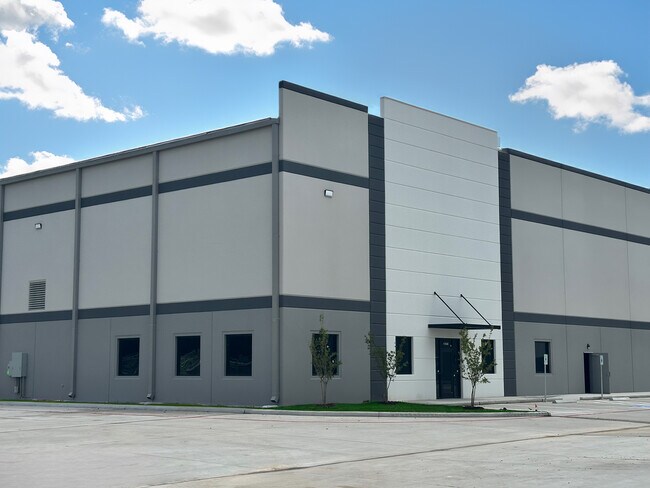
17580 Highway 59 N
Houston
Humble Commerce Center
Houston-The Woodlands-Sugar Land, TX
Harris
1423540010001
Texas
Warehouse
3.40 AC
67,600 SF
Northeast Hwy 90
DEMOGRAPHICS near 17580 Highway 59 N
1 Mile
3 Mile
5 Mile
2024 Total Population
2,884
49,954
129,566
2029 Population
2,929
50,727
133,227
Pop Growth 2024-2029
+ 1.56%
+ 1.55%
+ 2.83%
Average Age
38
34
34
2024 Total Households
979
16,727
42,245
HH Growth 2024-2029
+ 1.33%
+ 1.42%
+ 2.84%
Median Household Inc
$72,499
$62,726
$69,350
Avg Household Size
2.90
2.90
3.00
2024 Avg HH Vehicles
2.00
2.00
2.00
Median Home Value
$162,903
$174,701
$203,100
Median Year Built
1984
1994
2002
Nearby Places
Map Layers
Map Styles
 Street
 Aerial
- Restaurants
- Banks
- Shops
- Fitness
- Groceries
PUBLIC TRANSPORTATION
AIRPORT
George Bush Intcntl/Houston
DRIVE
WALK
Distance
George Bush Intcntl/Houston
11 min
7.2 mi
William P Hobby
DRIVE
WALK
Distance
William P Hobby
44 min
29.2 mi
Freight Ports
Port of Houston
DRIVE
WALK
Distance
Port of Houston
33 min
22.9 mi
SALE & LEASE HISTORY
LISTING DATE
SALE/LEASE

Aug 10, 2023
For Sale
Aug 09, 2023
For Lease
Nearby Properties
Address
Land Use
TOTAL SIZE
Lot Size
Zoning
Address
Land Use
TOTAL SIZE
Lot Size
Zoning
687,195 SF
33.75 AC
Address
Land Use
TOTAL SIZE
Lot Size
Zoning
785,390 SF
66.02 AC
Address
Land Use
TOTAL SIZE
Lot Size
Zoning
685,400 SF
38.82 AC
Address
Land Use
TOTAL SIZE
Lot Size
Zoning
514,500 SF
40.85 AC
Address
Land Use
TOTAL SIZE
Lot Size
Zoning
567,528 SF
76.97 AC
Address
Land Use
TOTAL SIZE
Lot Size
Zoning
429,750 SF
24.74 AC
Address
Land Use
TOTAL SIZE
Lot Size
Zoning
391,060 SF
32.42 AC
Address
Land Use
TOTAL SIZE
Lot Size
Zoning
355,622 SF
15.78 AC
Address
Land Use
TOTAL SIZE
Lot Size
Zoning
432,617 SF
19.41 AC
Address
Land Use
TOTAL SIZE
Lot Size
Zoning
260,427 SF
4.50 AC
Address
Land Use
TOTAL SIZE
Lot Size
Zoning
334,510 SF
23.54 AC
Address
Land Use
TOTAL SIZE
Lot Size
Zoning
320,200 SF
19.56 AC
Address
Land Use
TOTAL SIZE
Lot Size
Zoning
73,500 SF
115.96 AC
Address
Land Use
TOTAL SIZE
Lot Size
Zoning
449,858 SF
22.20 AC
Address
Land Use
TOTAL SIZE
Lot Size
Zoning
235,236 SF
15.14 AC
Address
Land Use
TOTAL SIZE
Lot Size
Zoning
207,720 SF
12.33 AC
Address
Land Use
TOTAL SIZE
Lot Size
Zoning
321,604 SF
16.68 AC
Address
Land Use
TOTAL SIZE
Lot Size
Zoning
246,712 SF
13.33 AC
Address
Land Use
TOTAL SIZE
Lot Size
Zoning
309,744 SF
21.50 AC
Address
Land Use
TOTAL SIZE
Lot Size
Zoning
216,978 SF
10.99 AC
Address
Land Use
TOTAL SIZE
Lot Size
Zoning
276,464 SF
18.79 AC
Address
Land Use
TOTAL SIZE
Lot Size
Zoning
252,320 SF
22.14 AC
Address
Land Use
TOTAL SIZE
Lot Size
Zoning
205,040 SF
10.51 AC
Address
Land Use
TOTAL SIZE
Lot Size
Zoning
262,010 SF
12.64 AC
Address
Land Use
TOTAL SIZE
Lot Size
Zoning
242,788 SF
14.72 AC
Address
Land Use
TOTAL SIZE
Lot Size
Zoning
304,671 SF
14.77 AC
Address
Land Use
TOTAL SIZE
Lot Size
Zoning
196,468 SF
9.51 AC
Address
Land Use
TOTAL SIZE
Lot Size
Zoning
259,500 SF
12.28 AC
Address
Land Use
TOTAL SIZE
Lot Size
Zoning
207,432 SF
15.12 AC
Address
Land Use
TOTAL SIZE
Lot Size
Zoning
208,230 SF
14.79 AC
The World's #1 Commercial Real Estate Marketplace
Connect with us
© 2025 CoStar Group
The information above has been obtained from sources believed reliable. While we do not doubt its accuracy we have not verified it and make no guarantee, warranty or representation about it. It is your responsibility to independently confirm its accuracy and completeness. Any projections, opinions, assumptions, or estimates used are for example only and do not represent the current or future performance of the property. The value of this transaction to you depends on tax and other factors which should be evaluated by your tax, financial, and legal advisors. You and your advisors should conduct a careful, independent investigation of the property to determine to your satisfaction the suitability of the property for your needs.