Property Record
17598 N Interstate 35, West, TX 76691
NEARBY LISTINGS FOR SALE OR LEASE
-
-
View all West listings for sale on LoopNet.com
Property Detail
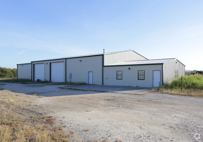
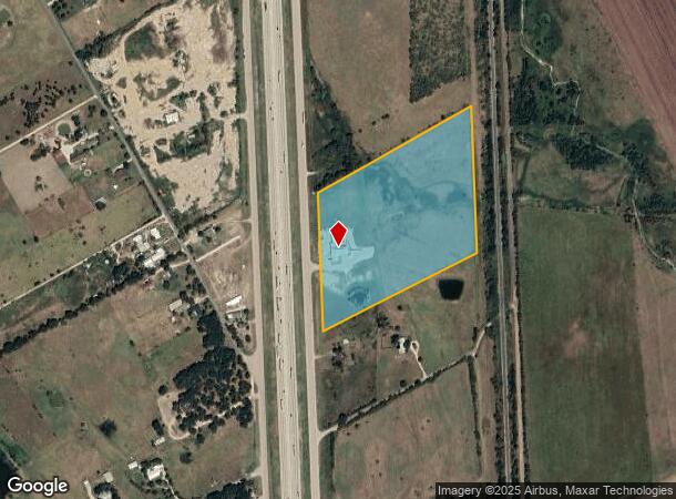
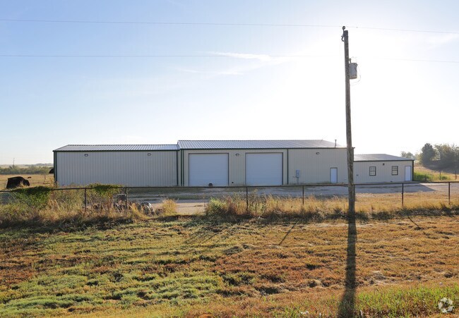
17598 N Interstate 35
Waco, TX
Altus A A-1167
50-116700-000502-6
ALTUS A A-1167 ACRES 18.55
Commercialnec
Mclennan
X
Texas
48309C0225D
5
2024
18.55 AC
2025
Waco
004201
Other Market Areas
8,300 SF
DEMOGRAPHICS near 17598 N Interstate 35
1 mile
3 mile
5 mile
2024 Total Population
187
1,515
7,702
2029 Population
189
1,541
7,964
Pop Growth 2024-2029
+ 1.07%
+ 1.72%
+ 3.40%
Average Age
42
41
41
2024 Total Households
73
578
2,953
HH Growth 2024-2029
+ 1.37%
+ 1.73%
+ 3.52%
Median Household Inc
$76,562
$72,187
$68,485
Avg Household Size
2.50
2.50
2.50
2024 Avg HH Vehicles
2.00
2.00
2.00
Median Home Value
$256,249
$217,857
$189,899
Median Year Built
1983
1983
1981
Nearby Places
Map Layers
Map Styles
 Street
 Aerial
Transit
 Traffic
 Biking
Places
Listings with unknown addresses are not visible on the map
- Restaurants
- Banks
- Shops
- Fitness
- Groceries
PUBLIC TRANSPORTATION
AIRPORT
Waco Regional
Drive
Walk
Distance
Waco Regional
35 min
20.5 mi
SALE & LEASE HISTORY
LISTING DATE
SALE/LEASE

Nov 02, 2016
For Sale
Nearby Properties
Address
Land Use
TOTAL SIZE
Lot Size
Zoning
Address
Land Use
TOTAL SIZE
Lot Size
Zoning
9,694 SF
34.11 AC
R
Address
Land Use
TOTAL SIZE
Lot Size
Zoning
13,379 SF
8.99 AC
C
Address
Land Use
TOTAL SIZE
Lot Size
Zoning
18,850 SF
21.94 AC
R
Address
Land Use
TOTAL SIZE
Lot Size
Zoning
12,952 SF
4.08 AC
R
Address
Land Use
TOTAL SIZE
Lot Size
Zoning
26,102 SF
5.66 AC
Address
Land Use
TOTAL SIZE
Lot Size
Zoning
36,001 SF
8.82 AC
R
Address
Land Use
TOTAL SIZE
Lot Size
Zoning
7,836 SF
83.61 AC
R
Address
Land Use
TOTAL SIZE
Lot Size
Zoning
20,550 SF
5.58 AC
R
Address
Land Use
TOTAL SIZE
Lot Size
Zoning
7,015 SF
21.11 AC
R
Address
Land Use
TOTAL SIZE
Lot Size
Zoning
1,104 SF
0.50 AC
R
Address
Land Use
TOTAL SIZE
Lot Size
Zoning
5,741 SF
3.74 AC
Address
Land Use
TOTAL SIZE
Lot Size
Zoning
10,456 SF
10 AC
Address
Land Use
TOTAL SIZE
Lot Size
Zoning
4,632 SF
3.98 AC
Address
Land Use
TOTAL SIZE
Lot Size
Zoning
6,698 SF
81.27 AC
R
Address
Land Use
TOTAL SIZE
Lot Size
Zoning
3,779 SF
10.10 AC
Address
Land Use
TOTAL SIZE
Lot Size
Zoning
4,887 SF
4.86 AC
R
Address
Land Use
TOTAL SIZE
Lot Size
Zoning
3,481 SF
1.50 AC
R
Address
Land Use
TOTAL SIZE
Lot Size
Zoning
3,041 SF
3.54 AC
Address
Land Use
TOTAL SIZE
Lot Size
Zoning
4,967 SF
1.52 AC
R
Address
Land Use
TOTAL SIZE
Lot Size
Zoning
3,029 SF
2 AC
Address
Land Use
TOTAL SIZE
Lot Size
Zoning
3,435 SF
7.72 AC
Address
Land Use
TOTAL SIZE
Lot Size
Zoning
3,314 SF
15.73 AC
R
Address
Land Use
TOTAL SIZE
Lot Size
Zoning
3,483 SF
2.84 AC
R
Address
Land Use
TOTAL SIZE
Lot Size
Zoning
3,982 SF
1.88 AC
R
Address
Land Use
TOTAL SIZE
Lot Size
Zoning
3,426 SF
21.96 AC
R
Address
Land Use
TOTAL SIZE
Lot Size
Zoning
10.87 AC
R
Address
Land Use
TOTAL SIZE
Lot Size
Zoning
3,632 SF
0.84 AC
R
Address
Land Use
TOTAL SIZE
Lot Size
Zoning
3,687 SF
80.13 AC
R
Address
Land Use
TOTAL SIZE
Lot Size
Zoning
5,169 SF
10 AC
R
The World's #1 Commercial Real Estate Marketplace
Connect with us
© 2026 CoStar Group
The information above has been obtained from sources believed reliable. While we do not doubt its accuracy we have not verified it and make no guarantee, warranty or representation about it. It is your responsibility to independently confirm its accuracy and completeness. Any projections, opinions, assumptions, or estimates used are for example only and do not represent the current or future performance of the property. The value of this transaction to you depends on tax and other factors which should be evaluated by your tax, financial, and legal advisors. You and your advisors should conduct a careful, independent investigation of the property to determine to your satisfaction the suitability of the property for your needs.