Property Record
176 Laurie Ellis Rd, Winterville, NC 28590

NEARBY LISTINGS FOR SALE OR LEASE
-
-
View all Winterville listings for sale on LoopNet.com
Property Detail
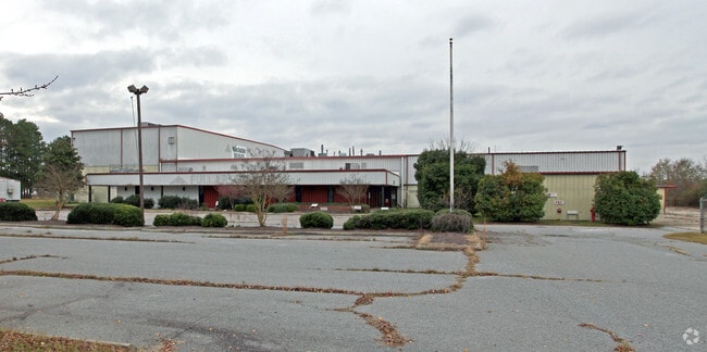
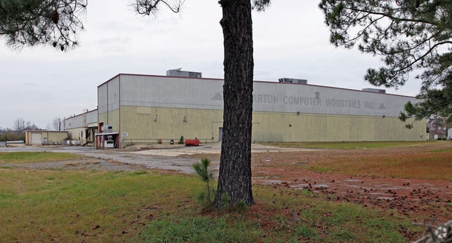
176 Laurie Ellis Rd
028124
Roberts Co Fabrication Sv
Officebuilding
PLANT S/R 1713-14
X
Pitt
3720467400J
North Carolina
2025
12.20 AC
2025
North Carolina Northeast Area
001302
Other Market Areas
88,760 SF
Greenville, NC
DEMOGRAPHICS near 176 Laurie Ellis Rd
1 Mile
3 Mile
5 Mile
2024 Total Population
4,606
23,347
66,253
2029 Population
4,848
24,217
69,234
Pop Growth 2024-2029
+ 5.25%
+ 3.73%
+ 4.50%
Average Age
38
37
37
2024 Total Households
1,769
9,095
27,868
HH Growth 2024-2029
+ 5.54%
+ 3.99%
+ 4.83%
Median Household Inc
$79,545
$69,018
$54,846
Avg Household Size
2.60
2.50
2.30
2024 Avg HH Vehicles
2.00
2.00
2.00
Median Home Value
$186,629
$190,337
$185,421
Median Year Built
2004
1998
1996
Nearby Places
Map Layers
Map Styles
 Street
 Aerial
- Restaurants
- Banks
- Shops
- Fitness
- Groceries
PUBLIC TRANSPORTATION
AIRPORT
Pitt-Greenville
DRIVE
WALK
Distance
Pitt-Greenville
16 min
8.9 mi
Coastal Carolina Regional
DRIVE
WALK
Distance
Coastal Carolina Regional
66 min
45.3 mi
Nearby Properties
Address
Land Use
TOTAL SIZE
Lot Size
Zoning
Address
Land Use
TOTAL SIZE
Lot Size
Zoning
33,163 SF
20.14 AC
OR
Address
Land Use
TOTAL SIZE
Lot Size
Zoning
251,145 SF
84.25 AC
RA20
Address
Land Use
TOTAL SIZE
Lot Size
Zoning
90,108 SF
11.27 AC
OI
Address
Land Use
TOTAL SIZE
Lot Size
Zoning
162,126 SF
30 AC
OI
Address
Land Use
TOTAL SIZE
Lot Size
Zoning
93,340 SF
14.63 AC
AR
Address
Land Use
TOTAL SIZE
Lot Size
Zoning
84,649 SF
44.78 AC
AR
Address
Land Use
TOTAL SIZE
Lot Size
Zoning
75,300 SF
8.64 AC
GB
Address
Land Use
TOTAL SIZE
Lot Size
Zoning
139,128 SF
6.57 AC
OI
Address
Land Use
TOTAL SIZE
Lot Size
Zoning
56,748 SF
1.72 AC
OI
Address
Land Use
TOTAL SIZE
Lot Size
Zoning
9,864 SF
19 AC
R6A
Address
Land Use
TOTAL SIZE
Lot Size
Zoning
42,124 SF
22.38 AC
OI
Address
Land Use
TOTAL SIZE
Lot Size
Zoning
137,320 SF
13.58 AC
GB
Address
Land Use
TOTAL SIZE
Lot Size
Zoning
49,299 SF
51.98 AC
AR
Address
Land Use
TOTAL SIZE
Lot Size
Zoning
75,880 SF
5.06 AC
CH
Address
Land Use
TOTAL SIZE
Lot Size
Zoning
49,379 SF
14.68 AC
RR
Address
Land Use
TOTAL SIZE
Lot Size
Zoning
93,331 SF
12.68 AC
CH
Address
Land Use
TOTAL SIZE
Lot Size
Zoning
42,168 SF
6.54 AC
CG
Address
Land Use
TOTAL SIZE
Lot Size
Zoning
147,400 SF
8 AC
GB
Address
Land Use
TOTAL SIZE
Lot Size
Zoning
36,650 SF
5 AC
RA20
Address
Land Use
TOTAL SIZE
Lot Size
Zoning
37,125 SF
15.25 AC
AR
Address
Land Use
TOTAL SIZE
Lot Size
Zoning
60,702 SF
6.43 AC
GB
Address
Land Use
TOTAL SIZE
Lot Size
Zoning
78,383 SF
9.10 AC
OI
Address
Land Use
TOTAL SIZE
Lot Size
Zoning
111,833 SF
20 AC
O
Address
Land Use
TOTAL SIZE
Lot Size
Zoning
29,552 SF
10 AC
R15
Address
Land Use
TOTAL SIZE
Lot Size
Zoning
79,686 SF
18.96 AC
I
Address
Land Use
TOTAL SIZE
Lot Size
Zoning
17,400 SF
90.38 AC
RR
Address
Land Use
TOTAL SIZE
Lot Size
Zoning
39,904 SF
4.60 AC
CG
Address
Land Use
TOTAL SIZE
Lot Size
Zoning
38,128 SF
16.35 AC
RR
Address
Land Use
TOTAL SIZE
Lot Size
Zoning
63,915 SF
20.74 AC
I
Address
Land Use
TOTAL SIZE
Lot Size
Zoning
11,396 SF
9.86 AC
R6
The World's #1 Commercial Real Estate Marketplace
Connect with us
© 2025 CoStar Group
The information above has been obtained from sources believed reliable. While we do not doubt its accuracy we have not verified it and make no guarantee, warranty or representation about it. It is your responsibility to independently confirm its accuracy and completeness. Any projections, opinions, assumptions, or estimates used are for example only and do not represent the current or future performance of the property. The value of this transaction to you depends on tax and other factors which should be evaluated by your tax, financial, and legal advisors. You and your advisors should conduct a careful, independent investigation of the property to determine to your satisfaction the suitability of the property for your needs.