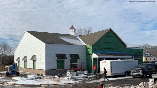
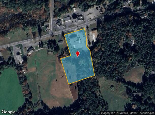
Property Record
176 W State St, Granby, MA 01033
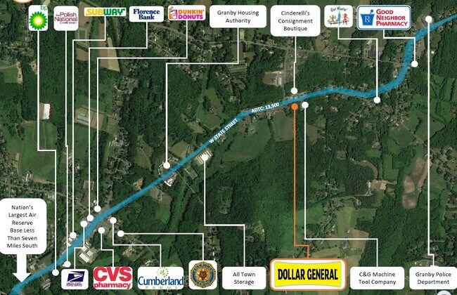
NEARBY LISTINGS FOR SALE OR LEASE
Property Detail
176 W State St
Springfield, MA
Hampshire
GRAN-000003-G000000-000011
Massachusetts
Departmentstore
11
2025
3.62 AC
2025
Hampshire County
820900
Hartford
7,252 SF
DEMOGRAPHICS near 176 W State St
1 Mile
3 Mile
5 Mile
2024 Total Population
1,049
13,183
38,095
2029 Population
826
10,836
32,900
Pop Growth 2024-2029
(21.26%)
(17.80%)
(13.64%)
Average Age
45
41
43
2024 Total Households
429
4,447
15,174
HH Growth 2024-2029
(22.61%)
(21.70%)
(14.84%)
Median Household Inc
$106,250
$99,420
$79,869
Avg Household Size
2.40
2.30
2.30
2024 Avg HH Vehicles
2.00
2.00
2.00
Median Home Value
$321,428
$322,017
$294,814
Median Year Built
1962
1962
1964
Nearby Places
Map Layers
Map Styles
 Street
 Aerial
- Restaurants
- Banks
- Shops
- Fitness
- Groceries
PUBLIC TRANSPORTATION
COMMUTER RAIL
Holyoke Amtrak (Valley Flyer - Amtrak, Vermonter - Amtrak)
DRIVE
WALK
Distance
Holyoke Amtrak (Valley Flyer - Amtrak, Vermonter - Amtrak)
12 min
6.8 mi
AIRPORT
Bradley International
DRIVE
WALK
Distance
Bradley International
52 min
27.1 mi
Freight Ports
Albany, NY Port
DRIVE
WALK
Distance
Albany, NY Port
112 min
89.2 mi
SALE & LEASE HISTORY
LISTING DATE
SALE/LEASE

Mar 22, 2021
For Sale
Jan 23, 2020
For Sale
Feb 01, 2021
For Sale
Nearby Properties
Address
Land Use
TOTAL SIZE
Lot Size
Zoning
Address
Land Use
TOTAL SIZE
Lot Size
Zoning
16.30 AC
RA2
Address
Land Use
TOTAL SIZE
Lot Size
Zoning
4.50 AC
RA2
Address
Land Use
TOTAL SIZE
Lot Size
Zoning
52 AC
RA1
Address
Land Use
TOTAL SIZE
Lot Size
Zoning
9 AC
RA2
Address
Land Use
TOTAL SIZE
Lot Size
Zoning
26.35 AC
RA2
Address
Land Use
TOTAL SIZE
Lot Size
Zoning
3.30 AC
RA2
Address
Land Use
TOTAL SIZE
Lot Size
Zoning
61,808 SF
8.53 AC
RA2
Address
Land Use
TOTAL SIZE
Lot Size
Zoning
2.44 AC
RA2
Address
Land Use
TOTAL SIZE
Lot Size
Zoning
16.36 AC
RA1
Address
Land Use
TOTAL SIZE
Lot Size
Zoning
1.09 AC
RA2
Address
Land Use
TOTAL SIZE
Lot Size
Zoning
1,361.42 AC
Address
Land Use
TOTAL SIZE
Lot Size
Zoning
2.20 AC
RA2
Address
Land Use
TOTAL SIZE
Lot Size
Zoning
6.20 AC
RA2
Address
Land Use
TOTAL SIZE
Lot Size
Zoning
55,376 SF
3.20 AC
RA1
Address
Land Use
TOTAL SIZE
Lot Size
Zoning
13.10 AC
RA1
Address
Land Use
TOTAL SIZE
Lot Size
Zoning
28.35 AC
Address
Land Use
TOTAL SIZE
Lot Size
Zoning
89,410 SF
29.90 AC
Address
Land Use
TOTAL SIZE
Lot Size
Zoning
37,000 SF
3.90 AC
BA1
Address
Land Use
TOTAL SIZE
Lot Size
Zoning
123,515 SF
28.10 AC
RA1
Address
Land Use
TOTAL SIZE
Lot Size
Zoning
503.95 AC
Address
Land Use
TOTAL SIZE
Lot Size
Zoning
39,602 SF
3.80 AC
RA2
Address
Land Use
TOTAL SIZE
Lot Size
Zoning
7 AC
RA2
Address
Land Use
TOTAL SIZE
Lot Size
Zoning
34,610 SF
8 AC
Address
Land Use
TOTAL SIZE
Lot Size
Zoning
117,000 SF
9.10 AC
IA
Address
Land Use
TOTAL SIZE
Lot Size
Zoning
27,230 SF
0.87 AC
RA2
Address
Land Use
TOTAL SIZE
Lot Size
Zoning
2 AC
BA
Address
Land Use
TOTAL SIZE
Lot Size
Zoning
2.20 AC
Address
Land Use
TOTAL SIZE
Lot Size
Zoning
71,011 SF
22.18 AC
Address
Land Use
TOTAL SIZE
Lot Size
Zoning
3.58 AC
Address
Land Use
TOTAL SIZE
Lot Size
Zoning
47,890 SF
5.97 AC
BA1
The World's #1 Commercial Real Estate Marketplace
Connect with us
© 2026 CoStar Group
The information above has been obtained from sources believed reliable. While we do not doubt its accuracy we have not verified it and make no guarantee, warranty or representation about it. It is your responsibility to independently confirm its accuracy and completeness. Any projections, opinions, assumptions, or estimates used are for example only and do not represent the current or future performance of the property. The value of this transaction to you depends on tax and other factors which should be evaluated by your tax, financial, and legal advisors. You and your advisors should conduct a careful, independent investigation of the property to determine to your satisfaction the suitability of the property for your needs.