Property Record
176 West St, Gardner, MA 01440
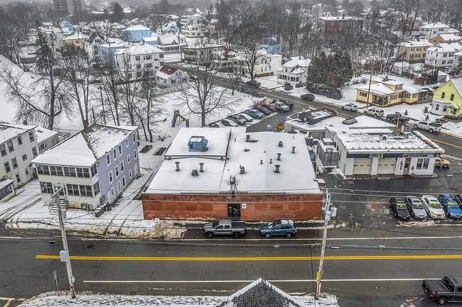

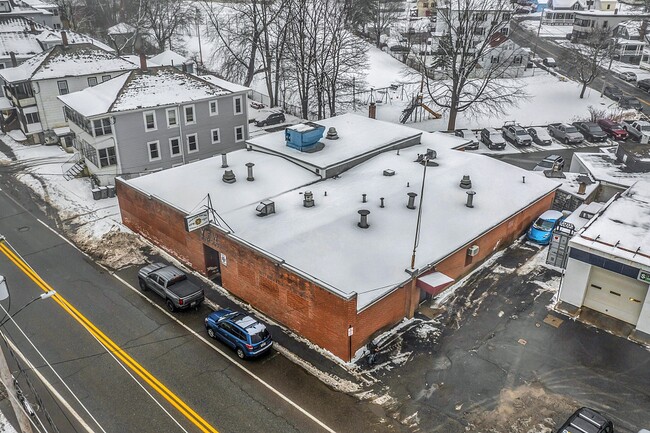
Property Detail
176 West St
GARD-000027M-000023-000046
Worcester
Charitableorganization
Massachusetts
B and X Area of moderate flood hazard, usually the area between the limits of the 100-year and 500-year floods.
46
2025
0.21 AC
2025
Outlying Worcester
707400
Boston
6,922 SF
Worcester, MA
NEARBY LISTINGS FOR SALE OR LEASE
DEMOGRAPHICS near 176 West St
1 mile
3 mile
5 mile
2025 Total Population
10,591
24,323
35,578
2030 Population
10,885
24,939
36,550
Pop Growth 2025-2030
+ 2.78%
+ 2.53%
+ 2.73%
Average Age
42
43
43
2025 Total Households
4,719
9,969
14,127
HH Growth 2025-2030
+ 2.99%
+ 2.73%
+ 2.88%
Median Household Inc
$56,328
$65,907
$76,397
Avg Household Size
2.20
2.30
2.40
2025 Avg HH Vehicles
1.00
2.00
2.00
Median Home Value
$271,213
$308,733
$335,852
Median Year Built
1948
1954
1960
Nearby Places
Map Layers
Map Styles
 Street
 Aerial
Layers
 Traffic
 Biking
Places
Listings with unknown addresses are not visible on the map
- Restaurants
- Banks
- Shops
- Fitness
- Groceries
PUBLIC TRANSPORTATION
COMMUTER RAIL
Drive
Walk
Distance
16 min
9.7 mi
AIRPORT
Worcester Regional
Drive
Walk
Distance
Worcester Regional
53 min
25.6 mi
Freight Ports
Port of Boston
Drive
Walk
Distance
Port of Boston
89 min
59.3 mi
SALE & LEASE HISTORY
LISTING DATE
SALE/LEASE

Jan 27, 2024
For Sale
Nearby Properties
Address
Land Use
TOTAL SIZE
Lot Size
Zoning
Address
Land Use
TOTAL SIZE
Lot Size
Zoning
321,793 SF
268 AC
Address
Land Use
TOTAL SIZE
Lot Size
Zoning
8.18 AC
Address
Land Use
TOTAL SIZE
Lot Size
Zoning
189,424 SF
12.60 AC
Address
Land Use
TOTAL SIZE
Lot Size
Zoning
104,279 SF
9.60 AC
Address
Land Use
TOTAL SIZE
Lot Size
Zoning
11.75 AC
Address
Land Use
TOTAL SIZE
Lot Size
Zoning
193,446 SF
17.34 AC
Address
Land Use
TOTAL SIZE
Lot Size
Zoning
123,353 SF
2.51 AC
Address
Land Use
TOTAL SIZE
Lot Size
Zoning
118,778 SF
1.25 AC
Address
Land Use
TOTAL SIZE
Lot Size
Zoning
15.68 AC
Address
Land Use
TOTAL SIZE
Lot Size
Zoning
7,644 SF
18.38 AC
Address
Land Use
TOTAL SIZE
Lot Size
Zoning
12.20 AC
Address
Land Use
TOTAL SIZE
Lot Size
Zoning
3.48 AC
Address
Land Use
TOTAL SIZE
Lot Size
Zoning
287,824 SF
5.87 AC
Address
Land Use
TOTAL SIZE
Lot Size
Zoning
3.60 AC
Address
Land Use
TOTAL SIZE
Lot Size
Zoning
32,562 SF
2.57 AC
Address
Land Use
TOTAL SIZE
Lot Size
Zoning
4.47 AC
Address
Land Use
TOTAL SIZE
Lot Size
Zoning
136,517 SF
11.01 AC
Address
Land Use
TOTAL SIZE
Lot Size
Zoning
2.90 AC
Address
Land Use
TOTAL SIZE
Lot Size
Zoning
16.03 AC
Address
Land Use
TOTAL SIZE
Lot Size
Zoning
8.17 AC
Address
Land Use
TOTAL SIZE
Lot Size
Zoning
11.38 AC
Address
Land Use
TOTAL SIZE
Lot Size
Zoning
80,507 SF
8.87 AC
Address
Land Use
TOTAL SIZE
Lot Size
Zoning
1.94 AC
Address
Land Use
TOTAL SIZE
Lot Size
Zoning
12.83 AC
Address
Land Use
TOTAL SIZE
Lot Size
Zoning
314,558 SF
5.27 AC
Address
Land Use
TOTAL SIZE
Lot Size
Zoning
63,414 SF
11.10 AC
Address
Land Use
TOTAL SIZE
Lot Size
Zoning
27,580 SF
0.71 AC
Address
Land Use
TOTAL SIZE
Lot Size
Zoning
64,100 SF
0.88 AC
Address
Land Use
TOTAL SIZE
Lot Size
Zoning
21.90 AC
Address
Land Use
TOTAL SIZE
Lot Size
Zoning
108,598 SF
11.97 AC
The World's #1 Commercial Real Estate Marketplace
Connect with us
© 2026 CoStar Group
The information above has been obtained from sources believed reliable. While we do not doubt its accuracy we have not verified it and make no guarantee, warranty or representation about it. It is your responsibility to independently confirm its accuracy and completeness. Any projections, opinions, assumptions, or estimates used are for example only and do not represent the current or future performance of the property. The value of this transaction to you depends on tax and other factors which should be evaluated by your tax, financial, and legal advisors. You and your advisors should conduct a careful, independent investigation of the property to determine to your satisfaction the suitability of the property for your needs.