Property Record
1760 Route 9, Garrison, NY 10524
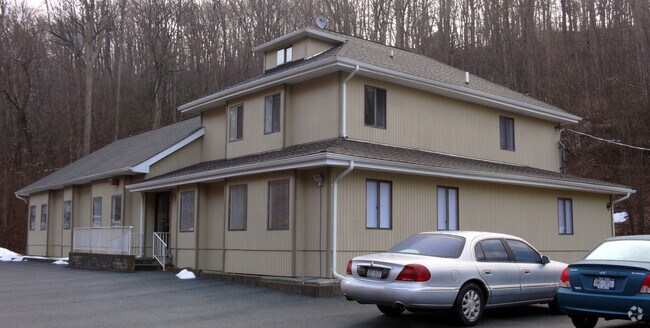

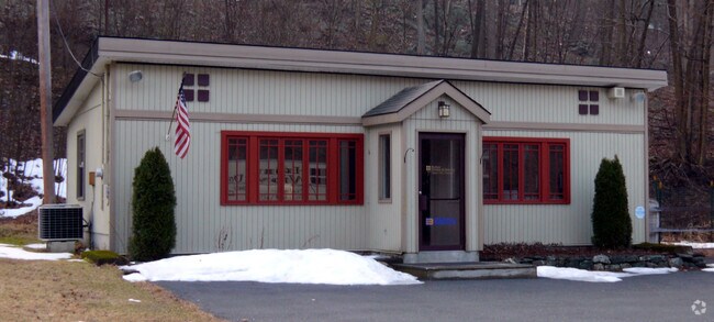

Property Detail
1760 Route 9
372689-071-000-0003-018-000-0000
PUTNAM
Commercialnec
New York
R40
18.00
B and X Area of moderate flood hazard, usually the area between the limits of the 100-year and 500-year floods.
1 AC
2024
Carmel
2025
Westchester/So Connecticut
010600
New York-Jersey City-White Plains, NY-NJ
4,974 SF
NEARBY LISTINGS FOR SALE OR LEASE
DEMOGRAPHICS near 1760 Route 9
1 mile
3 mile
5 mile
2025 Total Population
568
14,026
55,685
2030 Population
572
14,192
56,347
Pop Growth 2025-2030
+ 0.70%
+ 1.18%
+ 1.19%
Average Age
47
42
40
2025 Total Households
189
4,971
18,442
HH Growth 2025-2030
+ 1.06%
+ 1.27%
+ 1.18%
Median Household Inc
$115,624
$123,076
$120,798
Avg Household Size
2.60
2.60
2.70
2025 Avg HH Vehicles
2.00
2.00
2.00
Median Home Value
$653,061
$466,124
$473,352
Median Year Built
1956
1958
1961
Nearby Places
Map Layers
Map Styles
 Street
 Aerial
Layers
 Traffic
 Biking
Places
Listings with unknown addresses are not visible on the map
- Restaurants
- Banks
- Shops
- Fitness
- Groceries
PUBLIC TRANSPORTATION
COMMUTER RAIL
Garrison Station (Hudson Line - Metro-North Commuter Railroad Company (Metro-North))
Drive
Walk
Distance
Garrison Station (Hudson Line - Metro-North Commuter Railroad Company (Metro-North))
7 min
3.8 mi
Manitou Station (Hudson Line - Metro-North Commuter Railroad Company (Metro-North))
Drive
Walk
Distance
Manitou Station (Hudson Line - Metro-North Commuter Railroad Company (Metro-North))
14 min
7.2 mi
AIRPORT
New York Stewart International
Drive
Walk
Distance
New York Stewart International
37 min
26.3 mi
Westchester County
Drive
Walk
Distance
Westchester County
48 min
34.9 mi
Freight Ports
NY - Red Hook Container Terminal
Drive
Walk
Distance
NY - Red Hook Container Terminal
87 min
59.7 mi
SALE & LEASE HISTORY
LISTING DATE
SALE/LEASE

May 22, 2018
For Sale
Nearby Properties
Address
Land Use
TOTAL SIZE
Lot Size
Zoning
Address
Land Use
TOTAL SIZE
Lot Size
Zoning
363,657 SF
111.83 AC
B2
Address
Land Use
TOTAL SIZE
Lot Size
Zoning
19.90 AC
01
Address
Land Use
TOTAL SIZE
Lot Size
Zoning
119,474 SF
214.27 AC
R80
Address
Land Use
TOTAL SIZE
Lot Size
Zoning
78,529 SF
34.50 AC
R3
Address
Land Use
TOTAL SIZE
Lot Size
Zoning
95,159 SF
34.56 AC
B2
Address
Land Use
TOTAL SIZE
Lot Size
Zoning
69,828 SF
18.90 AC
R80
Address
Land Use
TOTAL SIZE
Lot Size
Zoning
233,706 SF
11.65 AC
R80
Address
Land Use
TOTAL SIZE
Lot Size
Zoning
Address
Land Use
TOTAL SIZE
Lot Size
Zoning
25,540 SF
6.70 AC
R-4
Address
Land Use
TOTAL SIZE
Lot Size
Zoning
5,380 SF
8.16 AC
CD
Address
Land Use
TOTAL SIZE
Lot Size
Zoning
14,720 SF
2.50 AC
R-5
Address
Land Use
TOTAL SIZE
Lot Size
Zoning
44,052 SF
23.97 AC
R80
Address
Land Use
TOTAL SIZE
Lot Size
Zoning
12,747 SF
35.73 AC
R80
Address
Land Use
TOTAL SIZE
Lot Size
Zoning
13,650 SF
16.46 AC
R80
Address
Land Use
TOTAL SIZE
Lot Size
Zoning
43,907 SF
1.20 AC
R-5
Address
Land Use
TOTAL SIZE
Lot Size
Zoning
35,775 SF
1.70 AC
R-5
Address
Land Use
TOTAL SIZE
Lot Size
Zoning
Address
Land Use
TOTAL SIZE
Lot Size
Zoning
19,138 SF
8.49 AC
R40
Address
Land Use
TOTAL SIZE
Lot Size
Zoning
17,300 SF
1.43 AC
B-1
Address
Land Use
TOTAL SIZE
Lot Size
Zoning
29,176 SF
66.77 AC
R80
Address
Land Use
TOTAL SIZE
Lot Size
Zoning
27,213 SF
1.20 AC
Address
Land Use
TOTAL SIZE
Lot Size
Zoning
21,729 SF
7.32 AC
B1
Address
Land Use
TOTAL SIZE
Lot Size
Zoning
11,880 SF
5 AC
R80
Address
Land Use
TOTAL SIZE
Lot Size
Zoning
11,252 SF
1.22 AC
B-1
Address
Land Use
TOTAL SIZE
Lot Size
Zoning
191,758 SF
20.03 AC
R80
Address
Land Use
TOTAL SIZE
Lot Size
Zoning
31,714 SF
13.88 AC
R2
Address
Land Use
TOTAL SIZE
Lot Size
Zoning
20,640 SF
22.22 AC
R80
Address
Land Use
TOTAL SIZE
Lot Size
Zoning
10,816 SF
9.87 AC
R80
Address
Land Use
TOTAL SIZE
Lot Size
Zoning
5,278 SF
67.05 AC
R3
Address
Land Use
TOTAL SIZE
Lot Size
Zoning
24,480 SF
0.55 AC
R-4
The World's #1 Commercial Real Estate Marketplace
Connect with us
© 2026 CoStar Group
The information above has been obtained from sources believed reliable. While we do not doubt its accuracy we have not verified it and make no guarantee, warranty or representation about it. It is your responsibility to independently confirm its accuracy and completeness. Any projections, opinions, assumptions, or estimates used are for example only and do not represent the current or future performance of the property. The value of this transaction to you depends on tax and other factors which should be evaluated by your tax, financial, and legal advisors. You and your advisors should conduct a careful, independent investigation of the property to determine to your satisfaction the suitability of the property for your needs.