Property Record
Highway 64 S Of, Eads, TN 38028
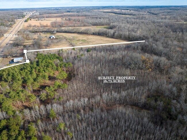
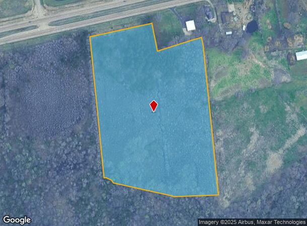
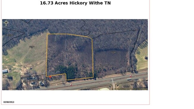
This Property Is For Sale
NEARBY LISTINGS FOR SALE OR LEASE
Property Detail
Highway 64 S Of
084-013.00
DISTRICT: 07, COUNTY AREA: P50
Agriculturalland
Fayette
AE
Tennessee
47047C0280C
16.73 AC
2024
Fayette County
2025
Memphis
060403
Memphis, TN-MS-AR
DEMOGRAPHICS near Highway 64 S Of
1 Mile
3 Mile
5 Mile
2024 Total Population
666
4,083
15,388
2029 Population
731
4,433
16,244
Pop Growth 2024-2029
+ 9.76%
+ 8.57%
+ 5.56%
Average Age
49
46
41
2024 Total Households
263
1,563
5,540
HH Growth 2024-2029
+ 9.51%
+ 8.38%
+ 5.83%
Median Household Inc
$123,437
$111,579
$101,376
Avg Household Size
2.50
2.60
2.70
2024 Avg HH Vehicles
3.00
3.00
2.00
Median Home Value
$419,565
$406,875
$341,545
Median Year Built
2002
2000
2002
Nearby Places
- Restaurants
- Banks
- Shops
- Fitness
- Groceries
PUBLIC TRANSPORTATION
AIRPORT
Memphis International
DRIVE
WALK
Distance
Memphis International
43 min
31.1 mi
Freight Ports
Port of Shreveport
DRIVE
WALK
Distance
Port of Shreveport
435 min
398.4 mi
Nearby Properties
Address
Land Use
TOTAL SIZE
Lot Size
Zoning
Address
Land Use
TOTAL SIZE
Lot Size
Zoning
60,234 SF
12.20 AC
Address
Land Use
TOTAL SIZE
Lot Size
Zoning
15,406 SF
9.28 AC
B-2
Address
Land Use
TOTAL SIZE
Lot Size
Zoning
72,100 SF
11.48 AC
B-2
Address
Land Use
TOTAL SIZE
Lot Size
Zoning
29,706 SF
20.38 AC
CA
Address
Land Use
TOTAL SIZE
Lot Size
Zoning
11,106 SF
4.02 AC
M-1
Address
Land Use
TOTAL SIZE
Lot Size
Zoning
18,144 SF
5.72 AC
M-1
Address
Land Use
TOTAL SIZE
Lot Size
Zoning
285.60 AC
E
Address
Land Use
TOTAL SIZE
Lot Size
Zoning
20,100 SF
2.13 AC
B2
Address
Land Use
TOTAL SIZE
Lot Size
Zoning
18,400 SF
2.13 AC
M-1
Address
Land Use
TOTAL SIZE
Lot Size
Zoning
14,400 SF
2.30 AC
B2
Address
Land Use
TOTAL SIZE
Lot Size
Zoning
10,060 SF
2.71 AC
M-1
Address
Land Use
TOTAL SIZE
Lot Size
Zoning
4,847 SF
2.59 AC
Address
Land Use
TOTAL SIZE
Lot Size
Zoning
8,219 SF
111.10 AC
Address
Land Use
TOTAL SIZE
Lot Size
Zoning
11,180 SF
4.05 AC
R-15
Address
Land Use
TOTAL SIZE
Lot Size
Zoning
11,190 SF
30 AC
Address
Land Use
TOTAL SIZE
Lot Size
Zoning
274.43 AC
E
Address
Land Use
TOTAL SIZE
Lot Size
Zoning
8,940 SF
3.42 AC
Address
Land Use
TOTAL SIZE
Lot Size
Zoning
138.07 AC
E
Address
Land Use
TOTAL SIZE
Lot Size
Zoning
8,032 SF
2.30 AC
Address
Land Use
TOTAL SIZE
Lot Size
Zoning
7,705 SF
1.75 AC
B2
Address
Land Use
TOTAL SIZE
Lot Size
Zoning
151.97 AC
E
Address
Land Use
TOTAL SIZE
Lot Size
Zoning
15,224 SF
102.44 AC
Address
Land Use
TOTAL SIZE
Lot Size
Zoning
237.67 AC
E
Address
Land Use
TOTAL SIZE
Lot Size
Zoning
4,080 SF
3.30 AC
B2
Address
Land Use
TOTAL SIZE
Lot Size
Zoning
3,232 SF
4.16 AC
B2
Address
Land Use
TOTAL SIZE
Lot Size
Zoning
7,011 SF
23.87 AC
Address
Land Use
TOTAL SIZE
Lot Size
Zoning
6,667 SF
17.77 AC
Address
Land Use
TOTAL SIZE
Lot Size
Zoning
3,894 SF
89.75 AC
E
Address
Land Use
TOTAL SIZE
Lot Size
Zoning
8,779 SF
21.15 AC
Address
Land Use
TOTAL SIZE
Lot Size
Zoning
5,387 SF
12.50 AC
CA
The World's #1 Commercial Real Estate Marketplace
Connect with us
© 2025 CoStar Group
The information above has been obtained from sources believed reliable. While we do not doubt its accuracy we have not verified it and make no guarantee, warranty or representation about it. It is your responsibility to independently confirm its accuracy and completeness. Any projections, opinions, assumptions, or estimates used are for example only and do not represent the current or future performance of the property. The value of this transaction to you depends on tax and other factors which should be evaluated by your tax, financial, and legal advisors. You and your advisors should conduct a careful, independent investigation of the property to determine to your satisfaction the suitability of the property for your needs.