Property Record
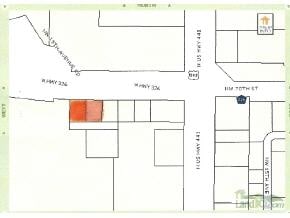
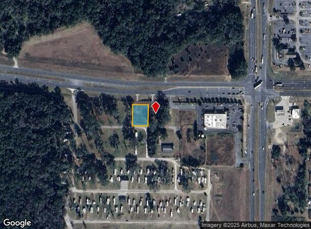
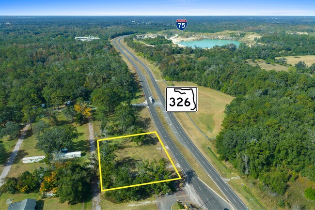
1760 W Highway 326, Ocala, FL 34475
This Property Is For Sale
NEARBY LISTINGS FOR SALE OR LEASE
Property Detail
1760 W Highway 326
13332-000-00
Ft And Being Sub
Residentialacreage
SEC 24 TWP 14 RGE 21 W 1/2 OF W 208.71 FT OF E 834.84 FT OF N 208.71 FT OF NE 1/4 OF SE 1/4 EX N 25 FT FOR RD R/W & EX ANY PORTION LYING WITHIN THE FOLLOWING DESCRIBED BOUNDRIES TAKEN FOR NEW ALIGNMENT OF SR 326: COM NE COR OF SE 1/4 THENCE N 89-33-1
X
Marion
12083C0319D
Florida
2024
0.35 AC
2024
Outlying Marion County
001500
Ocala
696 SF
Ocala, FL
DEMOGRAPHICS near 1760 W Highway 326
1 Mile
3 Mile
5 Mile
2024 Total Population
1,374
11,374
46,532
2029 Population
1,549
12,811
52,386
Pop Growth 2024-2029
+ 12.74%
+ 12.63%
+ 12.58%
Average Age
40
40
42
2024 Total Households
535
4,391
18,269
HH Growth 2024-2029
+ 12.71%
+ 12.69%
+ 12.79%
Median Household Inc
$38,361
$44,796
$47,178
Avg Household Size
2.50
2.50
2.40
2024 Avg HH Vehicles
2.00
2.00
2.00
Median Home Value
$220,763
$220,370
$173,891
Median Year Built
1989
1987
1985
Nearby Places
- Restaurants
- Banks
- Shops
- Fitness
- Groceries
PUBLIC TRANSPORTATION
AIRPORT
Gainesville Regional
DRIVE
WALK
Distance
Gainesville Regional
53 min
36.9 mi
Nearby Properties
Address
Land Use
TOTAL SIZE
Lot Size
Zoning
Address
Land Use
TOTAL SIZE
Lot Size
Zoning
612,196 SF
50.06 AC
M1
Address
Land Use
TOTAL SIZE
Lot Size
Zoning
617,520 SF
46.08 AC
M2
Address
Land Use
TOTAL SIZE
Lot Size
Zoning
444,381 SF
60 AC
M1
Address
Land Use
TOTAL SIZE
Lot Size
Zoning
350,895 SF
27.85 AC
M1
Address
Land Use
TOTAL SIZE
Lot Size
Zoning
140,920 SF
28.09 AC
M2
Address
Land Use
TOTAL SIZE
Lot Size
Zoning
384,930 SF
17.76 AC
M1
Address
Land Use
TOTAL SIZE
Lot Size
Zoning
116,876 SF
23.78 AC
M2
Address
Land Use
TOTAL SIZE
Lot Size
Zoning
73,361 SF
23.20 AC
GU
Address
Land Use
TOTAL SIZE
Lot Size
Zoning
47,984 SF
448.37 AC
PUD
Address
Land Use
TOTAL SIZE
Lot Size
Zoning
66,531 SF
26.96 AC
B2
Address
Land Use
TOTAL SIZE
Lot Size
Zoning
44,100 SF
9.60 AC
R3
Address
Land Use
TOTAL SIZE
Lot Size
Zoning
Address
Land Use
TOTAL SIZE
Lot Size
Zoning
89,640 SF
33.21 AC
B5
Address
Land Use
TOTAL SIZE
Lot Size
Zoning
72,855 SF
47.31 AC
B2
Address
Land Use
TOTAL SIZE
Lot Size
Zoning
57,558 SF
9.18 AC
B4
Address
Land Use
TOTAL SIZE
Lot Size
Zoning
47,900 SF
10.29 AC
B5
Address
Land Use
TOTAL SIZE
Lot Size
Zoning
115,909 SF
11.09 AC
RPUD
Address
Land Use
TOTAL SIZE
Lot Size
Zoning
41,195 SF
4 AC
B5
Address
Land Use
TOTAL SIZE
Lot Size
Zoning
16,430 SF
59.07 AC
A3
Address
Land Use
TOTAL SIZE
Lot Size
Zoning
27,776 SF
6.18 AC
A1
Address
Land Use
TOTAL SIZE
Lot Size
Zoning
43,737 SF
4.02 AC
B4
Address
Land Use
TOTAL SIZE
Lot Size
Zoning
10,894 SF
35.86 AC
B3
Address
Land Use
TOTAL SIZE
Lot Size
Zoning
49,915 SF
5 AC
PUD
Address
Land Use
TOTAL SIZE
Lot Size
Zoning
23,100 SF
4.18 AC
B2
Address
Land Use
TOTAL SIZE
Lot Size
Zoning
9,117 SF
18.84 AC
B3
Address
Land Use
TOTAL SIZE
Lot Size
Zoning
60,556 SF
11.73 AC
M1
Address
Land Use
TOTAL SIZE
Lot Size
Zoning
46,510 SF
3.64 AC
B4
Address
Land Use
TOTAL SIZE
Lot Size
Zoning
6,408 SF
11.31 AC
B5
Address
Land Use
TOTAL SIZE
Lot Size
Zoning
13,494 SF
40.14 AC
A1
The World's #1 Commercial Real Estate Marketplace
Connect with us
© 2025 CoStar Group
The information above has been obtained from sources believed reliable. While we do not doubt its accuracy we have not verified it and make no guarantee, warranty or representation about it. It is your responsibility to independently confirm its accuracy and completeness. Any projections, opinions, assumptions, or estimates used are for example only and do not represent the current or future performance of the property. The value of this transaction to you depends on tax and other factors which should be evaluated by your tax, financial, and legal advisors. You and your advisors should conduct a careful, independent investigation of the property to determine to your satisfaction the suitability of the property for your needs.