Property Record
1761 Princeton Kenly Rd, Kenly, NC 27542
NEARBY LISTINGS FOR SALE OR LEASE
-
-
View all Kenly listings for sale on LoopNet.com
Property Detail
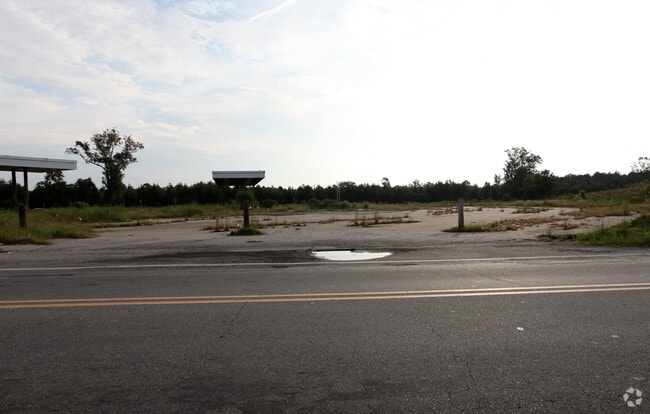
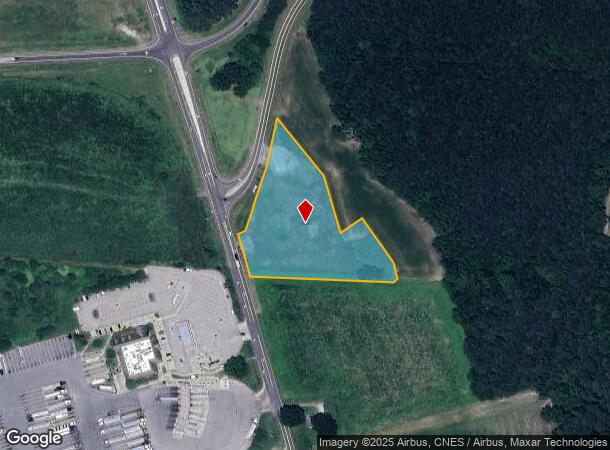
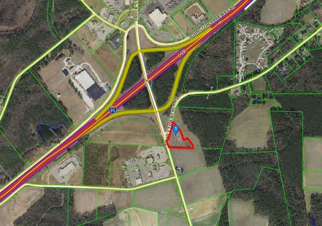
1761 Princeton Kenly Rd
03Q04001I
PARNELL HEIRS 50/376
Storebuilding
Johnston
X
North Carolina
3720265600J
2.93 AC
2025
Johnston County
2025
Raleigh/Durham
040101
Raleigh, NC
12,760 SF
DEMOGRAPHICS near 1761 Princeton Kenly Rd
1 Mile
3 Mile
5 Mile
2024 Total Population
396
4,221
9,593
2029 Population
475
5,045
11,353
Pop Growth 2024-2029
+ 19.95%
+ 19.52%
+ 18.35%
Average Age
41
41
41
2024 Total Households
161
1,679
3,756
HH Growth 2024-2029
+ 19.88%
+ 19.54%
+ 18.32%
Median Household Inc
$55,227
$52,200
$53,844
Avg Household Size
2.40
2.50
2.50
2024 Avg HH Vehicles
2.00
2.00
2.00
Median Home Value
$216,667
$195,907
$182,419
Median Year Built
1975
1986
1990
Nearby Places
Map Layers
Map Styles
 Street
 Aerial
- Restaurants
- Banks
- Shops
- Fitness
- Groceries
PUBLIC TRANSPORTATION
COMMUTER RAIL
DRIVE
WALK
Distance
13 min
8.9 mi
SALE & LEASE HISTORY
LISTING DATE
SALE/LEASE

Sep 24, 2016
For Sale
Nearby Properties
Address
Land Use
TOTAL SIZE
Lot Size
Zoning
Address
Land Use
TOTAL SIZE
Lot Size
Zoning
14,171 SF
42.48 AC
RAG
Address
Land Use
TOTAL SIZE
Lot Size
Zoning
37,474 SF
13.72 AC
IND
Address
Land Use
TOTAL SIZE
Lot Size
Zoning
136,190 SF
36.69 AC
COM
Address
Land Use
TOTAL SIZE
Lot Size
Zoning
35,869 SF
19.59 AC
IND
Address
Land Use
TOTAL SIZE
Lot Size
Zoning
27,506 SF
101.58 AC
COM
Address
Land Use
TOTAL SIZE
Lot Size
Zoning
4,871 SF
9.61 AC
COM
Address
Land Use
TOTAL SIZE
Lot Size
Zoning
9,279 SF
10.05 AC
IND
Address
Land Use
TOTAL SIZE
Lot Size
Zoning
36,972 SF
9.51 AC
COM
Address
Land Use
TOTAL SIZE
Lot Size
Zoning
44,157 SF
43.63 AC
IND
Address
Land Use
TOTAL SIZE
Lot Size
Zoning
3,200 SF
27.03 AC
COM
Address
Land Use
TOTAL SIZE
Lot Size
Zoning
15,813 SF
11.44 AC
RAG
Address
Land Use
TOTAL SIZE
Lot Size
Zoning
9,155 SF
1.31 AC
RA20
Address
Land Use
TOTAL SIZE
Lot Size
Zoning
32,800 SF
10.73 AC
COM
Address
Land Use
TOTAL SIZE
Lot Size
Zoning
24,104 SF
2 AC
COM
Address
Land Use
TOTAL SIZE
Lot Size
Zoning
14,725 SF
8.66 AC
RES
Address
Land Use
TOTAL SIZE
Lot Size
Zoning
26,880 SF
17.68 AC
IND
Address
Land Use
TOTAL SIZE
Lot Size
Zoning
9,300 SF
7.34 AC
COM
Address
Land Use
TOTAL SIZE
Lot Size
Zoning
31,213 SF
2.50 AC
COM
Address
Land Use
TOTAL SIZE
Lot Size
Zoning
6,724 SF
4.85 AC
COM
Address
Land Use
TOTAL SIZE
Lot Size
Zoning
33,608 SF
19.70 AC
IND
Address
Land Use
TOTAL SIZE
Lot Size
Zoning
16,910 SF
3 AC
COM
Address
Land Use
TOTAL SIZE
Lot Size
Zoning
3,720 SF
4.92 AC
IND
Address
Land Use
TOTAL SIZE
Lot Size
Zoning
5,318 SF
1.55 AC
COM
Address
Land Use
TOTAL SIZE
Lot Size
Zoning
14,498 SF
4.20 AC
COM
Address
Land Use
TOTAL SIZE
Lot Size
Zoning
10,120 SF
10.06 AC
IND
Address
Land Use
TOTAL SIZE
Lot Size
Zoning
1,376 SF
134.17 AC
IND
Address
Land Use
TOTAL SIZE
Lot Size
Zoning
8,400 SF
17.56 AC
COM
Address
Land Use
TOTAL SIZE
Lot Size
Zoning
8,250 SF
1.61 AC
IND
Address
Land Use
TOTAL SIZE
Lot Size
Zoning
18.37 AC
RES
The World's #1 Commercial Real Estate Marketplace
Connect with us
© 2026 CoStar Group
The information above has been obtained from sources believed reliable. While we do not doubt its accuracy we have not verified it and make no guarantee, warranty or representation about it. It is your responsibility to independently confirm its accuracy and completeness. Any projections, opinions, assumptions, or estimates used are for example only and do not represent the current or future performance of the property. The value of this transaction to you depends on tax and other factors which should be evaluated by your tax, financial, and legal advisors. You and your advisors should conduct a careful, independent investigation of the property to determine to your satisfaction the suitability of the property for your needs.