Property Record
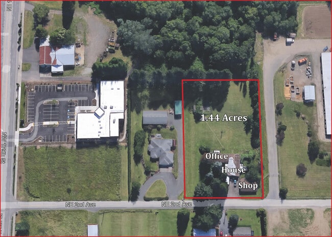
17612 Ne 2Nd Ave, Ridgefield, WA 98642


NEARBY LISTINGS FOR SALE OR LEASE
Property Detail
17612 Ne 2Nd Ave
Portland-Vancouver-Hillsboro, OR-WA
Clark
182209-000
Washington
Sfr
1 AC
X
Hazel Dell/Salmon Creek
53011C0356D
Portland
DEMOGRAPHICS near 17612 Ne 2Nd Ave
1 Mile
3 Mile
5 Mile
2024 Total Population
2,783
29,843
96,094
2029 Population
2,989
32,184
103,976
Pop Growth 2024-2029
+ 7.40%
+ 7.84%
+ 8.20%
Average Age
43
43
42
2024 Total Households
1,042
11,295
35,491
HH Growth 2024-2029
+ 7.49%
+ 8.10%
+ 8.32%
Median Household Inc
$103,057
$105,428
$98,961
Avg Household Size
2.70
2.60
2.70
2024 Avg HH Vehicles
2.00
2.00
2.00
Median Home Value
$595,046
$538,824
$505,417
Median Year Built
1996
1994
1994
Nearby Places
Map Layers
Map Styles
 Street
 Aerial
- Restaurants
- Banks
- Shops
- Fitness
- Groceries
PUBLIC TRANSPORTATION
AIRPORT
Portland International
DRIVE
WALK
Distance
Portland International
25 min
17.3 mi
Freight Ports
Port of Vancouver
DRIVE
WALK
Distance
Port of Vancouver
17 min
10.4 mi
SALE & LEASE HISTORY
LISTING DATE
SALE/LEASE

Oct 14, 2021
For Sale
Nearby Properties
Address
Land Use
TOTAL SIZE
Lot Size
Zoning
Address
Land Use
TOTAL SIZE
Lot Size
Zoning
494,738 SF
7.33 AC
GC
Address
Land Use
TOTAL SIZE
Lot Size
Zoning
540,669 SF
272.10 AC
U
Address
Land Use
TOTAL SIZE
Lot Size
Zoning
335,784 SF
12.93 AC
GC
Address
Land Use
TOTAL SIZE
Lot Size
Zoning
262,710 SF
14.99 AC
R-22
Address
Land Use
TOTAL SIZE
Lot Size
Zoning
275,000 SF
67.54 AC
R1-7.5
Address
Land Use
TOTAL SIZE
Lot Size
Zoning
173,174 SF
7.18 AC
OR-22
Address
Land Use
TOTAL SIZE
Lot Size
Zoning
143,094 SF
6.42 AC
OR-30
Address
Land Use
TOTAL SIZE
Lot Size
Zoning
477,314 SF
57.47 AC
PF
Address
Land Use
TOTAL SIZE
Lot Size
Zoning
107,064 SF
38.66 AC
U
Address
Land Use
TOTAL SIZE
Lot Size
Zoning
357,176 SF
9.82 AC
R-22
Address
Land Use
TOTAL SIZE
Lot Size
Zoning
93,616 SF
41.61 AC
PF
Address
Land Use
TOTAL SIZE
Lot Size
Zoning
146,302 SF
3.33 AC
GC
Address
Land Use
TOTAL SIZE
Lot Size
Zoning
141,175 SF
9.83 AC
R-18
Address
Land Use
TOTAL SIZE
Lot Size
Zoning
91,328 SF
7.38 AC
GC
Address
Land Use
TOTAL SIZE
Lot Size
Zoning
244,012 SF
2.83 AC
R-18
Address
Land Use
TOTAL SIZE
Lot Size
Zoning
163,716 SF
4.55 AC
R-12
Address
Land Use
TOTAL SIZE
Lot Size
Zoning
80,038 SF
3.78 AC
CC
Address
Land Use
TOTAL SIZE
Lot Size
Zoning
142,316 SF
4.01 AC
OR-30
Address
Land Use
TOTAL SIZE
Lot Size
Zoning
238,540 SF
29.47 AC
R1-10
Address
Land Use
TOTAL SIZE
Lot Size
Zoning
166,620 SF
14.85 AC
CC
Address
Land Use
TOTAL SIZE
Lot Size
Zoning
94,060 SF
3.19 AC
OR-30
Address
Land Use
TOTAL SIZE
Lot Size
Zoning
107,881 SF
5.19 AC
R-22
Address
Land Use
TOTAL SIZE
Lot Size
Zoning
64,141 SF
8.18 AC
R1-6
Address
Land Use
TOTAL SIZE
Lot Size
Zoning
80,843 SF
8.17 AC
GC
Address
Land Use
TOTAL SIZE
Lot Size
Zoning
87,654 SF
0.92 AC
CC
Address
Land Use
TOTAL SIZE
Lot Size
Zoning
203,157 SF
1.56 AC
GC
Address
Land Use
TOTAL SIZE
Lot Size
Zoning
138,825 SF
5.92 AC
OR-22
Address
Land Use
TOTAL SIZE
Lot Size
Zoning
52,907 SF
12.49 AC
GC
Address
Land Use
TOTAL SIZE
Lot Size
Zoning
80,818 SF
5.39 AC
R-18
The World's #1 Commercial Real Estate Marketplace
Connect with us
© 2026 CoStar Group
The information above has been obtained from sources believed reliable. While we do not doubt its accuracy we have not verified it and make no guarantee, warranty or representation about it. It is your responsibility to independently confirm its accuracy and completeness. Any projections, opinions, assumptions, or estimates used are for example only and do not represent the current or future performance of the property. The value of this transaction to you depends on tax and other factors which should be evaluated by your tax, financial, and legal advisors. You and your advisors should conduct a careful, independent investigation of the property to determine to your satisfaction the suitability of the property for your needs.