Property Record
17617 15Th Ave Se, Bothell, WA 98012
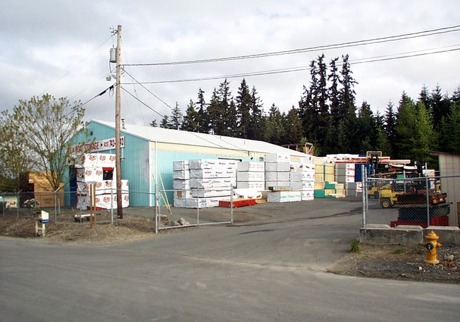

Property Detail
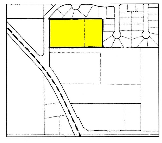
17617 15Th Ave Se
270507-004-041-00
SEC 07 TWP 27 RGE 05 LOT 1 OF ZA9007378SP REC AF 9210270690 BEING A PTN OF SE1/4 SE1/4
Storebuilding
SNOHOMISH
LI
Washington
B and X Area of moderate flood hazard, usually the area between the limits of the 100-year and 500-year floods.
1
2025
2.96 AC
2026
Mill Creek/N Creek
052007
Seattle/Puget Sound
4,250 SF
Seattle-Tacoma-Bellevue, WA
NEARBY LISTINGS FOR SALE OR LEASE
DEMOGRAPHICS near 17617 15Th Ave Se
1 mile
3 mile
5 mile
2025 Total Population
16,077
134,588
356,869
2030 Population
16,604
140,581
371,880
Pop Growth 2025-2030
+ 3.28%
+ 4.45%
+ 4.21%
Average Age
37
38
39
2025 Total Households
5,806
47,738
130,576
HH Growth 2025-2030
+ 3.43%
+ 4.58%
+ 4.31%
Median Household Inc
$146,510
$138,141
$120,202
Avg Household Size
2.70
2.80
2.70
2025 Avg HH Vehicles
2.00
2.00
2.00
Median Home Value
$789,283
$816,980
$778,825
Median Year Built
1991
2000
1994
Nearby Places
Map Layers
Map Styles
 Street
 Aerial
Layers
 Traffic
 Biking
Places
Listings with unknown addresses are not visible on the map
- Restaurants
- Banks
- Shops
- Fitness
- Groceries
PUBLIC TRANSPORTATION
AIRPORT
Seattle Paine Field International
Drive
Walk
Distance
Seattle Paine Field International
17 min
7.7 mi
Seattle-Tacoma International
Drive
Walk
Distance
Seattle-Tacoma International
49 min
33.6 mi
Freight Ports
Port of Everett
Drive
Walk
Distance
Port of Everett
21 min
11.8 mi
Nearby Properties
Address
Land Use
TOTAL SIZE
Lot Size
Zoning
Address
Land Use
TOTAL SIZE
Lot Size
Zoning
813,456 SF
30.76 AC
PRC
Address
Land Use
TOTAL SIZE
Lot Size
Zoning
581,232 SF
43.22 AC
UC
Address
Land Use
TOTAL SIZE
Lot Size
Zoning
421,873 SF
9.06 AC
PCD
Address
Land Use
TOTAL SIZE
Lot Size
Zoning
329,964 SF
20.07 AC
MR
Address
Land Use
TOTAL SIZE
Lot Size
Zoning
426,238 SF
9.84 AC
UC
Address
Land Use
TOTAL SIZE
Lot Size
Zoning
619,673 SF
0.34 AC
UC
Address
Land Use
TOTAL SIZE
Lot Size
Zoning
375,816 SF
40.36 AC
MU/HDR
Address
Land Use
TOTAL SIZE
Lot Size
Zoning
524,803 SF
PRC
Address
Land Use
TOTAL SIZE
Lot Size
Zoning
372,073 SF
9.11 AC
UC
Address
Land Use
TOTAL SIZE
Lot Size
Zoning
217,071 SF
36.47 AC
R-9,600
Address
Land Use
TOTAL SIZE
Lot Size
Zoning
233,025 SF
3.97 AC
R-9,600
Address
Land Use
TOTAL SIZE
Lot Size
Zoning
285,554 SF
15 AC
HDR
Address
Land Use
TOTAL SIZE
Lot Size
Zoning
241,956 SF
20 AC
HDR
Address
Land Use
TOTAL SIZE
Lot Size
Zoning
262,618 SF
7.05 AC
MU/HDR
Address
Land Use
TOTAL SIZE
Lot Size
Zoning
386,535 SF
2.21 AC
UC
Address
Land Use
TOTAL SIZE
Lot Size
Zoning
394,152 SF
18 AC
E-M
Address
Land Use
TOTAL SIZE
Lot Size
Zoning
250,800 SF
11.69 AC
UC
Address
Land Use
TOTAL SIZE
Lot Size
Zoning
181,008 SF
9.76 AC
E-L
Address
Land Use
TOTAL SIZE
Lot Size
Zoning
57.84 AC
R-9,600
Address
Land Use
TOTAL SIZE
Lot Size
Zoning
291,349 SF
12.42 AC
MU/HDR
Address
Land Use
TOTAL SIZE
Lot Size
Zoning
47,176 SF
38.88 AC
R 9,600
Address
Land Use
TOTAL SIZE
Lot Size
Zoning
236,844 SF
9.02 AC
CB
Address
Land Use
TOTAL SIZE
Lot Size
Zoning
213,689 SF
7.46 AC
UC
Address
Land Use
TOTAL SIZE
Lot Size
Zoning
864 SF
42.79 AC
LDR
Address
Land Use
TOTAL SIZE
Lot Size
Zoning
177,325 SF
20.54 AC
R-9,600
Address
Land Use
TOTAL SIZE
Lot Size
Zoning
195,366 SF
10.66 AC
MR
Address
Land Use
TOTAL SIZE
Lot Size
Zoning
243,504 SF
13.84 AC
CB
Address
Land Use
TOTAL SIZE
Lot Size
Zoning
189,700 SF
18.85 AC
OR-L
Address
Land Use
TOTAL SIZE
Lot Size
Zoning
19,041 SF
8.17 AC
MR
Address
Land Use
TOTAL SIZE
Lot Size
Zoning
283,224 SF
16.87 AC
MR
The World's #1 Commercial Real Estate Marketplace
Connect with us
© 2026 CoStar Group
The information above has been obtained from sources believed reliable. While we do not doubt its accuracy we have not verified it and make no guarantee, warranty or representation about it. It is your responsibility to independently confirm its accuracy and completeness. Any projections, opinions, assumptions, or estimates used are for example only and do not represent the current or future performance of the property. The value of this transaction to you depends on tax and other factors which should be evaluated by your tax, financial, and legal advisors. You and your advisors should conduct a careful, independent investigation of the property to determine to your satisfaction the suitability of the property for your needs.