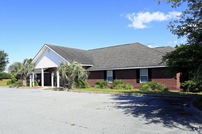
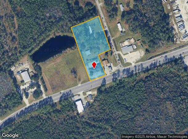
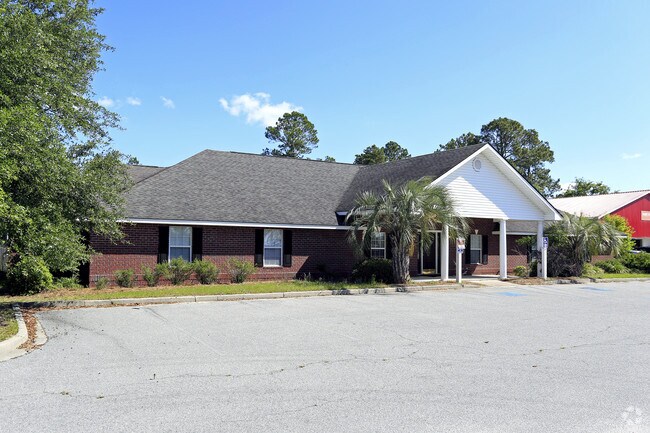
Property Record
1763 Ga Highway 196 W, Hinesville, GA 31313
NEARBY LISTINGS FOR SALE OR LEASE
Property Detail
1763 Ga Highway 196 W
036D-004
Gmass Commercial
Commercialnec
TRACT C N/S HWY 196 W
X
Liberty
13179C0210E
Georgia
2024
3.74 AC
2024
Liberty County
010205
Savannah
5,014 SF
Hinesville, GA
DEMOGRAPHICS near 1763 Ga Highway 196 W
1 Mile
3 Mile
5 Mile
2024 Total Population
3,470
31,597
52,054
2029 Population
3,627
33,373
56,208
Pop Growth 2024-2029
+ 4.52%
+ 5.62%
+ 7.98%
Average Age
32
33
33
2024 Total Households
1,320
11,680
18,383
HH Growth 2024-2029
+ 4.85%
+ 5.66%
+ 8.03%
Median Household Inc
$52,031
$48,868
$48,668
Avg Household Size
2.60
2.70
2.60
2024 Avg HH Vehicles
2.00
2.00
2.00
Median Home Value
$147,841
$148,552
$153,171
Median Year Built
1992
1992
1991
Nearby Places
Map Layers
Map Styles
 Street
 Aerial
- Restaurants
- Banks
- Shops
- Fitness
- Groceries
PUBLIC TRANSPORTATION
AIRPORT
Savannah/Hilton Head International
DRIVE
WALK
Distance
Savannah/Hilton Head International
61 min
41.9 mi
Freight Ports
Georgia Ports - Savannah
DRIVE
WALK
Distance
Georgia Ports - Savannah
65 min
44.0 mi
SALE & LEASE HISTORY
LISTING DATE
SALE/LEASE

Sep 25, 2016
For Lease
Nearby Properties
Address
Land Use
TOTAL SIZE
Lot Size
Zoning
Address
Land Use
TOTAL SIZE
Lot Size
Zoning
3,354 SF
58.90 AC
C3/R20
Address
Land Use
TOTAL SIZE
Lot Size
Zoning
258,552 SF
41.57 AC
PUD
Address
Land Use
TOTAL SIZE
Lot Size
Zoning
24,288 SF
12.05 AC
PUD
Address
Land Use
TOTAL SIZE
Lot Size
Zoning
148,364 SF
18.53 AC
PUD
Address
Land Use
TOTAL SIZE
Lot Size
Zoning
100,765 SF
33.20 AC
C2
Address
Land Use
TOTAL SIZE
Lot Size
Zoning
11,944 SF
39.41 AC
LI
Address
Land Use
TOTAL SIZE
Lot Size
Zoning
90,886 SF
10.78 AC
C2
Address
Land Use
TOTAL SIZE
Lot Size
Zoning
81,366 SF
28.01 AC
R20
Address
Land Use
TOTAL SIZE
Lot Size
Zoning
1,884 SF
9.25 AC
C2
Address
Land Use
TOTAL SIZE
Lot Size
Zoning
81,366 SF
35.17 AC
R8
Address
Land Use
TOTAL SIZE
Lot Size
Zoning
81,366 SF
16.50 AC
R20
Address
Land Use
TOTAL SIZE
Lot Size
Zoning
205,730 SF
21.03 AC
C3
Address
Land Use
TOTAL SIZE
Lot Size
Zoning
71,899 SF
50.12 AC
LI
Address
Land Use
TOTAL SIZE
Lot Size
Zoning
57,980 SF
10.72 AC
C2
Address
Land Use
TOTAL SIZE
Lot Size
Zoning
155,001 SF
10.56 AC
MFR
Address
Land Use
TOTAL SIZE
Lot Size
Zoning
53,103 SF
34.03 AC
I1
Address
Land Use
TOTAL SIZE
Lot Size
Zoning
105,967 SF
11.18 AC
C2
Address
Land Use
TOTAL SIZE
Lot Size
Zoning
110,150 SF
14.83 AC
C3
Address
Land Use
TOTAL SIZE
Lot Size
Zoning
133,379 SF
15.59 AC
C2
Address
Land Use
TOTAL SIZE
Lot Size
Zoning
42,572 SF
5.27 AC
C2
Address
Land Use
TOTAL SIZE
Lot Size
Zoning
12,261 SF
10.99 AC
C2
Address
Land Use
TOTAL SIZE
Lot Size
Zoning
39,252 SF
4.93 AC
MFR
Address
Land Use
TOTAL SIZE
Lot Size
Zoning
42,110 SF
5.86 AC
C3
Address
Land Use
TOTAL SIZE
Lot Size
Zoning
14,274 SF
6.34 AC
MFR
Address
Land Use
TOTAL SIZE
Lot Size
Zoning
24,144 SF
9.24 AC
C3
Address
Land Use
TOTAL SIZE
Lot Size
Zoning
2,969 SF
24.68 AC
MFR
Address
Land Use
TOTAL SIZE
Lot Size
Zoning
34,484 SF
1.92 AC
C2
Address
Land Use
TOTAL SIZE
Lot Size
Zoning
52,137 SF
6.12 AC
C2
Address
Land Use
TOTAL SIZE
Lot Size
Zoning
24,833 SF
6.07 AC
C2
Address
Land Use
TOTAL SIZE
Lot Size
Zoning
4,050 SF
8.20 AC
C2
The World's #1 Commercial Real Estate Marketplace
Connect with us
© 2026 CoStar Group
The information above has been obtained from sources believed reliable. While we do not doubt its accuracy we have not verified it and make no guarantee, warranty or representation about it. It is your responsibility to independently confirm its accuracy and completeness. Any projections, opinions, assumptions, or estimates used are for example only and do not represent the current or future performance of the property. The value of this transaction to you depends on tax and other factors which should be evaluated by your tax, financial, and legal advisors. You and your advisors should conduct a careful, independent investigation of the property to determine to your satisfaction the suitability of the property for your needs.