Property Record
17635 Ne 67Th Ct, Redmond, WA 98052
This Property Is For Sale
NEARBY LISTINGS FOR SALE OR LEASE
Property Detail
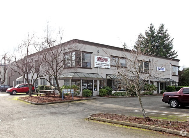
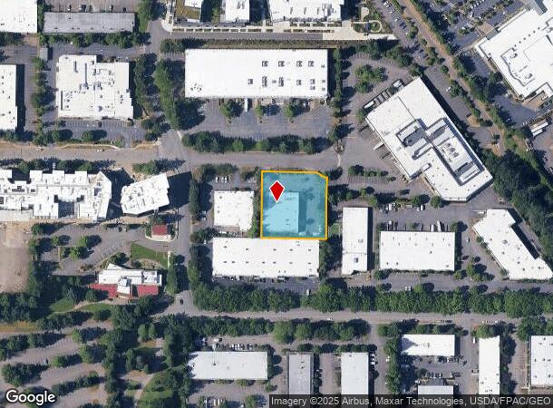
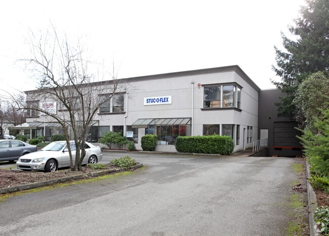
17635 Ne 67Th Ct
Seattle-Tacoma-Bellevue, WA
Marymoor Business Campus
519550-0030
MARYMOOR BUSINESS CAMPUS
Warehouse
King
X
Washington
53033C0386H
3
2025
0.83 AC
2024
Redmond
032313
Seattle/Puget Sound
17,352 SF
DEMOGRAPHICS near 17635 Ne 67Th Ct
1 Mile
3 Mile
5 Mile
2024 Total Population
8,691
98,482
233,779
2029 Population
8,726
99,591
236,147
Pop Growth 2024-2029
+ 0.40%
+ 1.13%
+ 1.01%
Average Age
33
36
38
2024 Total Households
3,813
39,784
91,407
HH Growth 2024-2029
+ 0.55%
+ 1.28%
+ 1.07%
Median Household Inc
$142,109
$151,282
$158,373
Avg Household Size
2.30
2.40
2.50
2024 Avg HH Vehicles
1.00
2.00
2.00
Median Home Value
$722,128
$1,005,905
$1,024,145
Median Year Built
1999
1989
1987
Nearby Places
- Restaurants
- Banks
- Shops
- Fitness
- Groceries
PUBLIC TRANSPORTATION
AIRPORT
Seattle Paine Field International
DRIVE
WALK
Distance
Seattle Paine Field International
37 min
23.0 mi
Seattle-Tacoma International
DRIVE
WALK
Distance
Seattle-Tacoma International
37 min
25.0 mi
Freight Ports
Port of Seattle
DRIVE
WALK
Distance
Port of Seattle
32 min
20.8 mi
Nearby Properties
Address
Land Use
TOTAL SIZE
Lot Size
Zoning
Address
Land Use
TOTAL SIZE
Lot Size
Zoning
223,745 SF
98.45 AC
OBAT
Address
Land Use
TOTAL SIZE
Lot Size
Zoning
482,658 SF
5.78 AC
BR-CR
Address
Land Use
TOTAL SIZE
Lot Size
Zoning
300,118 SF
29.12 AC
OBAT
Address
Land Use
TOTAL SIZE
Lot Size
Zoning
215,279 SF
14.92 AC
OBAT
Address
Land Use
TOTAL SIZE
Lot Size
Zoning
146,798 SF
19.63 AC
OBAT
Address
Land Use
TOTAL SIZE
Lot Size
Zoning
171,186 SF
16.45 AC
OBAT
Address
Land Use
TOTAL SIZE
Lot Size
Zoning
353,024 SF
3.19 AC
OV
Address
Land Use
TOTAL SIZE
Lot Size
Zoning
424,532 SF
30.49 AC
OUMF
Address
Land Use
TOTAL SIZE
Lot Size
Zoning
210,846 SF
9.09 AC
OBAT
Address
Land Use
TOTAL SIZE
Lot Size
Zoning
747,347 SF
8.91 AC
BP
Address
Land Use
TOTAL SIZE
Lot Size
Zoning
113,412 SF
10.26 AC
OBAT
Address
Land Use
TOTAL SIZE
Lot Size
Zoning
368,500 SF
38 AC
NR
Address
Land Use
TOTAL SIZE
Lot Size
Zoning
120,444 SF
25.29 AC
OBAT
Address
Land Use
TOTAL SIZE
Lot Size
Zoning
457,543 SF
1.83 AC
OV
Address
Land Use
TOTAL SIZE
Lot Size
Zoning
342,000 SF
24.18 AC
OUMF
Address
Land Use
TOTAL SIZE
Lot Size
Zoning
364,208 SF
16.94 AC
NMF
Address
Land Use
TOTAL SIZE
Lot Size
Zoning
231,088 SF
2.10 AC
TWNC
Address
Land Use
TOTAL SIZE
Lot Size
Zoning
270,158 SF
3.03 AC
TSQ
Address
Land Use
TOTAL SIZE
Lot Size
Zoning
279,488 SF
20.82 AC
NMF
Address
Land Use
TOTAL SIZE
Lot Size
Zoning
209,322 SF
1.45 AC
OV
Address
Land Use
TOTAL SIZE
Lot Size
Zoning
282,532 SF
16.57 AC
NMF
Address
Land Use
TOTAL SIZE
Lot Size
Zoning
422,038 SF
7.01 AC
OBAT
Address
Land Use
TOTAL SIZE
Lot Size
Zoning
230,400 SF
1.26 AC
OV
Address
Land Use
TOTAL SIZE
Lot Size
Zoning
793,294 SF
7.07 AC
OBAT
Address
Land Use
TOTAL SIZE
Lot Size
Zoning
209,400 SF
1.80 AC
TSQ
Address
Land Use
TOTAL SIZE
Lot Size
Zoning
65,000 SF
13.57 AC
EH
Address
Land Use
TOTAL SIZE
Lot Size
Zoning
420,705 SF
8.22 AC
OBAT
Address
Land Use
TOTAL SIZE
Lot Size
Zoning
298,849 SF
3.99 AC
OBAT
Address
Land Use
TOTAL SIZE
Lot Size
Zoning
300,628 SF
4.43 AC
OBAT
Address
Land Use
TOTAL SIZE
Lot Size
Zoning
141,158 SF
15.81 AC
OBAT
The World's #1 Commercial Real Estate Marketplace
Connect with us
© 2025 CoStar Group
The information above has been obtained from sources believed reliable. While we do not doubt its accuracy we have not verified it and make no guarantee, warranty or representation about it. It is your responsibility to independently confirm its accuracy and completeness. Any projections, opinions, assumptions, or estimates used are for example only and do not represent the current or future performance of the property. The value of this transaction to you depends on tax and other factors which should be evaluated by your tax, financial, and legal advisors. You and your advisors should conduct a careful, independent investigation of the property to determine to your satisfaction the suitability of the property for your needs.