Property Record
1765 River Rd, Hawesville, KY 42348


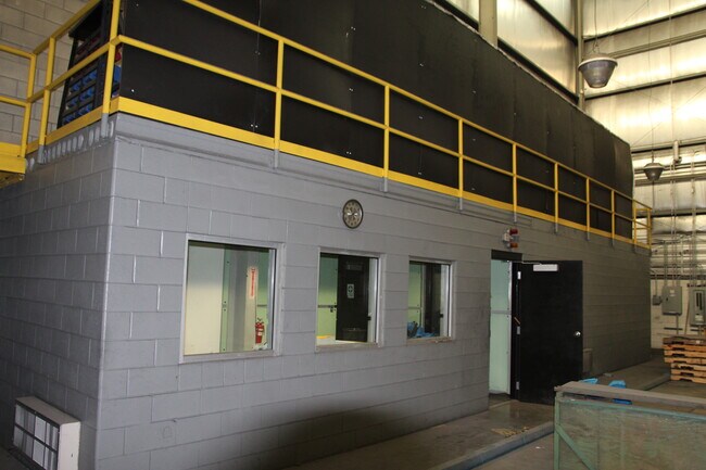
Property Detail
1765 River Rd
29-05-01
INDUSTRIAL SITE & 5 AC
Commercialnec
Hancock
AE The base floodplain where base flood elevations are provided. AE Zones are now used on new format FIRMs instead of A1-A30 Zones.
Kentucky
2025
5 AC
2025
Kentucky West Area
960100
Other Market Areas
NEARBY LISTINGS FOR SALE OR LEASE
DEMOGRAPHICS near 1765 River Rd
1 mile
3 mile
5 mile
2025 Total Population
283
11,112
13,920
2030 Population
278
11,027
13,811
Pop Growth 2025-2030
(1.77%)
(0.76%)
(0.78%)
Average Age
42
42
42
2025 Total Households
129
4,819
5,933
HH Growth 2025-2030
(1.55%)
(0.73%)
(0.74%)
Median Household Inc
$54,166
$53,076
$55,697
Avg Household Size
2.20
2.20
2.30
2025 Avg HH Vehicles
2.00
2.00
2.00
Median Home Value
$160,869
$144,930
$151,562
Median Year Built
1963
1965
1968
Nearby Places
Map Layers
Map Styles
 Street
 Aerial
Layers
 Traffic
 Biking
Places
Listings with unknown addresses are not visible on the map
- Restaurants
- Banks
- Shops
- Fitness
- Groceries
SALE & LEASE HISTORY
LISTING DATE
SALE/LEASE

Jan 08, 2019
For Sale
Aug 07, 2020
For Sale
Nearby Properties
Address
Land Use
TOTAL SIZE
Lot Size
Zoning
Address
Land Use
TOTAL SIZE
Lot Size
Zoning
Address
Land Use
TOTAL SIZE
Lot Size
Zoning
Address
Land Use
TOTAL SIZE
Lot Size
Zoning
82.03 AC
Address
Land Use
TOTAL SIZE
Lot Size
Zoning
196,103 SF
11.13 AC
Address
Land Use
TOTAL SIZE
Lot Size
Zoning
200,000 SF
24.96 AC
Address
Land Use
TOTAL SIZE
Lot Size
Zoning
Address
Land Use
TOTAL SIZE
Lot Size
Zoning
11,900 SF
5.83 AC
Z03
Address
Land Use
TOTAL SIZE
Lot Size
Zoning
122,489 SF
0.77 AC
Address
Land Use
TOTAL SIZE
Lot Size
Zoning
45,047 SF
2.25 AC
Address
Land Use
TOTAL SIZE
Lot Size
Zoning
35,774 SF
2.71 AC
Address
Land Use
TOTAL SIZE
Lot Size
Zoning
18,480 SF
1.29 AC
Address
Land Use
TOTAL SIZE
Lot Size
Zoning
33.03 AC
Address
Land Use
TOTAL SIZE
Lot Size
Zoning
27,414 SF
2.26 AC
Address
Land Use
TOTAL SIZE
Lot Size
Zoning
17,286 SF
2.53 AC
Address
Land Use
TOTAL SIZE
Lot Size
Zoning
85,903 SF
5 AC
Address
Land Use
TOTAL SIZE
Lot Size
Zoning
171,120 SF
274.56 AC
Address
Land Use
TOTAL SIZE
Lot Size
Zoning
201,640 SF
2.62 AC
Address
Land Use
TOTAL SIZE
Lot Size
Zoning
1.01 AC
Z03
Address
Land Use
TOTAL SIZE
Lot Size
Zoning
59,511 SF
0.23 AC
Address
Land Use
TOTAL SIZE
Lot Size
Zoning
9,230 SF
2.04 AC
Address
Land Use
TOTAL SIZE
Lot Size
Zoning
58,230 SF
4.20 AC
Address
Land Use
TOTAL SIZE
Lot Size
Zoning
21,230 SF
2.58 AC
Address
Land Use
TOTAL SIZE
Lot Size
Zoning
40,000 SF
2.89 AC
Address
Land Use
TOTAL SIZE
Lot Size
Zoning
0.71 AC
Address
Land Use
TOTAL SIZE
Lot Size
Zoning
4.53 AC
Address
Land Use
TOTAL SIZE
Lot Size
Zoning
78,582 SF
0.97 AC
Address
Land Use
TOTAL SIZE
Lot Size
Zoning
46,837 SF
3.30 AC
Address
Land Use
TOTAL SIZE
Lot Size
Zoning
22,020 SF
0.39 AC
Address
Land Use
TOTAL SIZE
Lot Size
Zoning
26,380 SF
1.50 AC
Address
Land Use
TOTAL SIZE
Lot Size
Zoning
1.05 AC
Z03
The World's #1 Commercial Real Estate Marketplace
Connect with us
© 2026 CoStar Group
The information above has been obtained from sources believed reliable. While we do not doubt its accuracy we have not verified it and make no guarantee, warranty or representation about it. It is your responsibility to independently confirm its accuracy and completeness. Any projections, opinions, assumptions, or estimates used are for example only and do not represent the current or future performance of the property. The value of this transaction to you depends on tax and other factors which should be evaluated by your tax, financial, and legal advisors. You and your advisors should conduct a careful, independent investigation of the property to determine to your satisfaction the suitability of the property for your needs.