Property Record
17656 Highway 550, Montrose, CO 81403
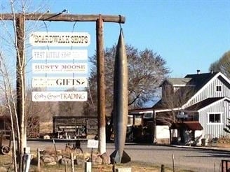

Property Detail
17656 Highway 550
Montrose, CO
SUBD: BOARDWALK EXEMPTION FOR BOUNDARY LINE ADJUSTMENT AN AMENDMENT OF LOT 1 CROSS 7 RANCHETTES & BRUNNER MINOR SUBD LOT: 1
R0023445
Montrose
Storebuilding
Colorado
B and X Area of moderate flood hazard, usually the area between the limits of the 100-year and 500-year floods.
1
2025
5.46 AC
2025
Colorado Southwest Area
966501
Other Market Areas
3,159 SF
NEARBY LISTINGS FOR SALE OR LEASE
DEMOGRAPHICS near 17656 Highway 550
1 mile
3 mile
5 mile
2025 Total Population
666
9,382
28,624
2030 Population
699
9,827
29,945
Pop Growth 2025-2030
+ 4.95%
+ 4.74%
+ 4.62%
Average Age
49
47
44
2025 Total Households
266
4,119
12,057
HH Growth 2025-2030
+ 4.89%
+ 4.83%
+ 4.63%
Median Household Inc
$68,823
$77,196
$72,509
Avg Household Size
2.40
2.20
2.30
2025 Avg HH Vehicles
3.00
2.00
2.00
Median Home Value
$608,156
$479,786
$398,778
Median Year Built
1996
1996
1992
Nearby Places
Map Layers
Map Styles
 Street
 Aerial
Transit
 Traffic
 Biking
Places
Listings with unknown addresses are not visible on the map
- Restaurants
- Banks
- Shops
- Fitness
- Groceries
PUBLIC TRANSPORTATION
AIRPORT
Montrose Regional
Drive
Walk
Distance
Montrose Regional
19 min
8.0 mi
Freight Ports
Port of San Diego
Drive
Walk
Distance
Port of San Diego
958 min
901.8 mi
SALE & LEASE HISTORY
LISTING DATE
SALE/LEASE

Nov 27, 2024
For Lease
Nov 17, 2021
For Lease
Apr 19, 2024
For Lease
Nearby Properties
Address
Land Use
TOTAL SIZE
Lot Size
Zoning
Address
Land Use
TOTAL SIZE
Lot Size
Zoning
82,754 SF
21.29 AC
Address
Land Use
TOTAL SIZE
Lot Size
Zoning
84,927 SF
15.45 AC
Address
Land Use
TOTAL SIZE
Lot Size
Zoning
83,990 SF
Address
Land Use
TOTAL SIZE
Lot Size
Zoning
52,533 SF
3.73 AC
Address
Land Use
TOTAL SIZE
Lot Size
Zoning
204,041 SF
17.30 AC
Address
Land Use
TOTAL SIZE
Lot Size
Zoning
63,757 SF
2.14 AC
Address
Land Use
TOTAL SIZE
Lot Size
Zoning
9,607 SF
17.78 AC
Address
Land Use
TOTAL SIZE
Lot Size
Zoning
128,307 SF
10.88 AC
Address
Land Use
TOTAL SIZE
Lot Size
Zoning
68,768 SF
7.73 AC
Address
Land Use
TOTAL SIZE
Lot Size
Zoning
23,617 SF
16.03 AC
Address
Land Use
TOTAL SIZE
Lot Size
Zoning
33,554 SF
10 AC
Address
Land Use
TOTAL SIZE
Lot Size
Zoning
97,056 SF
11.51 AC
Address
Land Use
TOTAL SIZE
Lot Size
Zoning
250,620 SF
21.70 AC
Address
Land Use
TOTAL SIZE
Lot Size
Zoning
26,915 SF
8.51 AC
Address
Land Use
TOTAL SIZE
Lot Size
Zoning
44,918 SF
4.49 AC
Address
Land Use
TOTAL SIZE
Lot Size
Zoning
48,396 SF
7.94 AC
Address
Land Use
TOTAL SIZE
Lot Size
Zoning
18,074 SF
8.70 AC
Address
Land Use
TOTAL SIZE
Lot Size
Zoning
15,300 SF
13.38 AC
Address
Land Use
TOTAL SIZE
Lot Size
Zoning
16,745 SF
2.28 AC
Address
Land Use
TOTAL SIZE
Lot Size
Zoning
40,461 SF
3.14 AC
Address
Land Use
TOTAL SIZE
Lot Size
Zoning
34,971 SF
1.46 AC
Address
Land Use
TOTAL SIZE
Lot Size
Zoning
49,960 SF
4.73 AC
B2
Address
Land Use
TOTAL SIZE
Lot Size
Zoning
68,768 SF
7.73 AC
Address
Land Use
TOTAL SIZE
Lot Size
Zoning
19,243 SF
3.13 AC
Address
Land Use
TOTAL SIZE
Lot Size
Zoning
7,197 SF
4 AC
Address
Land Use
TOTAL SIZE
Lot Size
Zoning
11,104 SF
Address
Land Use
TOTAL SIZE
Lot Size
Zoning
5,292 SF
4.96 AC
Address
Land Use
TOTAL SIZE
Lot Size
Zoning
34,571 SF
4.21 AC
Address
Land Use
TOTAL SIZE
Lot Size
Zoning
34,920 SF
2.34 AC
Address
Land Use
TOTAL SIZE
Lot Size
Zoning
10,331 SF
2.46 AC
The World's #1 Commercial Real Estate Marketplace
Connect with us
© 2026 CoStar Group
The information above has been obtained from sources believed reliable. While we do not doubt its accuracy we have not verified it and make no guarantee, warranty or representation about it. It is your responsibility to independently confirm its accuracy and completeness. Any projections, opinions, assumptions, or estimates used are for example only and do not represent the current or future performance of the property. The value of this transaction to you depends on tax and other factors which should be evaluated by your tax, financial, and legal advisors. You and your advisors should conduct a careful, independent investigation of the property to determine to your satisfaction the suitability of the property for your needs.