Property Record
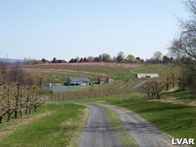
1767 Clearview Rd, Coplay, PA 18037

NEARBY LISTINGS FOR SALE OR LEASE
Property Detail
1767 Clearview Rd
Allentown-Bethlehem-Easton, PA-NJ
Act 319P
557087824007-1
LOTS: 001
Agriculturalnec
Lehigh
X
Pennsylvania
42077C0133F
1
2025
64.61 AC
2025
Lehigh Valley
005601
Philadelphia
DEMOGRAPHICS near 1767 Clearview Rd
1 Mile
3 Mile
5 Mile
2024 Total Population
1,049
20,894
65,665
2029 Population
1,056
21,047
66,005
Pop Growth 2024-2029
+ 0.67%
+ 0.73%
+ 0.52%
Average Age
44
43
43
2024 Total Households
388
8,218
26,353
HH Growth 2024-2029
+ 0.77%
+ 0.73%
+ 0.53%
Median Household Inc
$103,274
$82,383
$75,697
Avg Household Size
2.70
2.50
2.50
2024 Avg HH Vehicles
2.00
2.00
2.00
Median Home Value
$323,889
$260,210
$247,374
Median Year Built
1979
1976
1973
Nearby Places
Map Layers
Map Styles
 Street
 Aerial
- Restaurants
- Banks
- Shops
- Fitness
- Groceries
PUBLIC TRANSPORTATION
AIRPORT
Lehigh Valley International
DRIVE
WALK
Distance
Lehigh Valley International
19 min
9.8 mi
Freight Ports
Port of Philadelphia
DRIVE
WALK
Distance
Port of Philadelphia
91 min
67.6 mi
Nearby Properties
Address
Land Use
TOTAL SIZE
Lot Size
Zoning
Address
Land Use
TOTAL SIZE
Lot Size
Zoning
64,809 SF
9.66 AC
SR
Address
Land Use
TOTAL SIZE
Lot Size
Zoning
24,878 SF
20.66 AC
AR
Address
Land Use
TOTAL SIZE
Lot Size
Zoning
3,611 SF
108 AC
ME-I
Address
Land Use
TOTAL SIZE
Lot Size
Zoning
27,128 SF
1.70 AC
C
Address
Land Use
TOTAL SIZE
Lot Size
Zoning
1,920 SF
26.19 AC
VR
Address
Land Use
TOTAL SIZE
Lot Size
Zoning
42,602 SF
17.93 AC
SR
Address
Land Use
TOTAL SIZE
Lot Size
Zoning
2,339 SF
202.96 AC
OS-2
Address
Land Use
TOTAL SIZE
Lot Size
Zoning
79.14 AC
OS-2
Address
Land Use
TOTAL SIZE
Lot Size
Zoning
44,041 SF
1.21 AC
R-5A
Address
Land Use
TOTAL SIZE
Lot Size
Zoning
12,376 SF
4.04 AC
R-5A
Address
Land Use
TOTAL SIZE
Lot Size
Zoning
48,109 SF
4.19 AC
I
Address
Land Use
TOTAL SIZE
Lot Size
Zoning
23,887 SF
13.91 AC
AR
Address
Land Use
TOTAL SIZE
Lot Size
Zoning
10,448 SF
3.65 AC
R-6
Address
Land Use
TOTAL SIZE
Lot Size
Zoning
5,064 SF
3.31 AC
R-3A
Address
Land Use
TOTAL SIZE
Lot Size
Zoning
15,130 SF
2.59 AC
C
Address
Land Use
TOTAL SIZE
Lot Size
Zoning
74.49 AC
OS-2
Address
Land Use
TOTAL SIZE
Lot Size
Zoning
1,800 SF
51.79 AC
ME-I
Address
Land Use
TOTAL SIZE
Lot Size
Zoning
73.40 AC
OS-2
Address
Land Use
TOTAL SIZE
Lot Size
Zoning
11,307 SF
4.84 AC
AR
Address
Land Use
TOTAL SIZE
Lot Size
Zoning
7,601 SF
2.36 AC
R-5A
Address
Land Use
TOTAL SIZE
Lot Size
Zoning
51,750 SF
4.31 AC
R3
Address
Land Use
TOTAL SIZE
Lot Size
Zoning
3.50 AC
R-1
Address
Land Use
TOTAL SIZE
Lot Size
Zoning
28,352 SF
3.08 AC
I
Address
Land Use
TOTAL SIZE
Lot Size
Zoning
14,819 SF
0.53 AC
C-1
Address
Land Use
TOTAL SIZE
Lot Size
Zoning
2,632 SF
55.57 AC
ME-I
Address
Land Use
TOTAL SIZE
Lot Size
Zoning
49.35 AC
ME-I
Address
Land Use
TOTAL SIZE
Lot Size
Zoning
30,514 SF
3.01 AC
I
Address
Land Use
TOTAL SIZE
Lot Size
Zoning
2.30 AC
R-4
Address
Land Use
TOTAL SIZE
Lot Size
Zoning
7.04 AC
AR
Address
Land Use
TOTAL SIZE
Lot Size
Zoning
10,844 SF
2.88 AC
I
The World's #1 Commercial Real Estate Marketplace
Connect with us
© 2026 CoStar Group
The information above has been obtained from sources believed reliable. While we do not doubt its accuracy we have not verified it and make no guarantee, warranty or representation about it. It is your responsibility to independently confirm its accuracy and completeness. Any projections, opinions, assumptions, or estimates used are for example only and do not represent the current or future performance of the property. The value of this transaction to you depends on tax and other factors which should be evaluated by your tax, financial, and legal advisors. You and your advisors should conduct a careful, independent investigation of the property to determine to your satisfaction the suitability of the property for your needs.