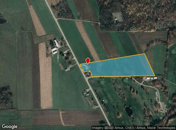
Property Record
17689 Route 8, Union City, PA 16438
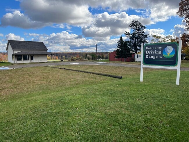
This Property Is For Sale
NEARBY LISTINGS FOR SALE OR LEASE
-
-
View all Union City listings for sale on LoopNet.com
Property Detail
17689 Route 8
Erie, PA
Burler Sundivision No 3
43-019-052.0-012.01
17689 ROUTE 8 10.9665 AC
Recreationcenter
Erie
X
Pennsylvania
42049C0655D
10.97 AC
2025
Outlying Erie County
2025
Erie
012001
DEMOGRAPHICS near 17689 Route 8
1 Mile
3 Mile
5 Mile
2024 Total Population
78
3,403
7,019
2029 Population
78
3,454
7,123
Pop Growth 2024-2029
0.00%
+ 1.50%
+ 1.48%
Average Age
45
42
43
2024 Total Households
32
1,378
2,857
HH Growth 2024-2029
0.00%
+ 1.60%
+ 1.61%
Median Household Inc
$64,500
$54,466
$57,155
Avg Household Size
2.50
2.40
2.40
2024 Avg HH Vehicles
2.00
2.00
2.00
Median Home Value
$162,499
$124,310
$138,948
Median Year Built
1973
1954
1959
Nearby Places
Map Layers
Map Styles
 Street
 Aerial
- Restaurants
- Banks
- Shops
- Fitness
- Groceries
PUBLIC TRANSPORTATION
AIRPORT
Erie International/Tom Ridge Field
DRIVE
WALK
Distance
Erie International/Tom Ridge Field
47 min
28.4 mi
Freight Ports
Port of Toledo
DRIVE
WALK
Distance
Port of Toledo
277 min
230.1 mi
Nearby Properties
Address
Land Use
TOTAL SIZE
Lot Size
Zoning
Address
Land Use
TOTAL SIZE
Lot Size
Zoning
19.66 AC
R2
Address
Land Use
TOTAL SIZE
Lot Size
Zoning
31 AC
R2
Address
Land Use
TOTAL SIZE
Lot Size
Zoning
1.04 AC
R1
Address
Land Use
TOTAL SIZE
Lot Size
Zoning
1.95 AC
R2
Address
Land Use
TOTAL SIZE
Lot Size
Zoning
29,943 SF
4.32 AC
Address
Land Use
TOTAL SIZE
Lot Size
Zoning
70,623 SF
50.35 AC
B2
Address
Land Use
TOTAL SIZE
Lot Size
Zoning
81,318 SF
5.16 AC
B2
Address
Land Use
TOTAL SIZE
Lot Size
Zoning
7,038 SF
0.48 AC
R2
Address
Land Use
TOTAL SIZE
Lot Size
Zoning
67,888 SF
5.66 AC
R2
Address
Land Use
TOTAL SIZE
Lot Size
Zoning
0.70 AC
B2
Address
Land Use
TOTAL SIZE
Lot Size
Zoning
504 SF
33.06 AC
R1
Address
Land Use
TOTAL SIZE
Lot Size
Zoning
960 SF
138.96 AC
OR
Address
Land Use
TOTAL SIZE
Lot Size
Zoning
1.09 AC
R1
Address
Land Use
TOTAL SIZE
Lot Size
Zoning
0.29 AC
B1
Address
Land Use
TOTAL SIZE
Lot Size
Zoning
35.75 AC
R1
Address
Land Use
TOTAL SIZE
Lot Size
Zoning
74,450 SF
2.70 AC
B2
Address
Land Use
TOTAL SIZE
Lot Size
Zoning
195,976 SF
6.83 AC
B2
Address
Land Use
TOTAL SIZE
Lot Size
Zoning
26,632 SF
1 AC
R2
Address
Land Use
TOTAL SIZE
Lot Size
Zoning
2,251 SF
363.64 AC
OR
Address
Land Use
TOTAL SIZE
Lot Size
Zoning
9,190 SF
2.89 AC
LI
Address
Land Use
TOTAL SIZE
Lot Size
Zoning
5,420 SF
1.13 AC
R2
Address
Land Use
TOTAL SIZE
Lot Size
Zoning
1,579 SF
314.57 AC
OR
Address
Land Use
TOTAL SIZE
Lot Size
Zoning
34,359 SF
0.83 AC
B1
Address
Land Use
TOTAL SIZE
Lot Size
Zoning
0.32 AC
R2
Address
Land Use
TOTAL SIZE
Lot Size
Zoning
3,520 SF
9.93 AC
Address
Land Use
TOTAL SIZE
Lot Size
Zoning
2,984 SF
40.67 AC
OR
Address
Land Use
TOTAL SIZE
Lot Size
Zoning
23.17 AC
R2
Address
Land Use
TOTAL SIZE
Lot Size
Zoning
9,056 SF
0.66 AC
LI
Address
Land Use
TOTAL SIZE
Lot Size
Zoning
22.10 AC
R2
Address
Land Use
TOTAL SIZE
Lot Size
Zoning
2,436 SF
0.06 AC
B1
The World's #1 Commercial Real Estate Marketplace
Connect with us
© 2025 CoStar Group
The information above has been obtained from sources believed reliable. While we do not doubt its accuracy we have not verified it and make no guarantee, warranty or representation about it. It is your responsibility to independently confirm its accuracy and completeness. Any projections, opinions, assumptions, or estimates used are for example only and do not represent the current or future performance of the property. The value of this transaction to you depends on tax and other factors which should be evaluated by your tax, financial, and legal advisors. You and your advisors should conduct a careful, independent investigation of the property to determine to your satisfaction the suitability of the property for your needs.