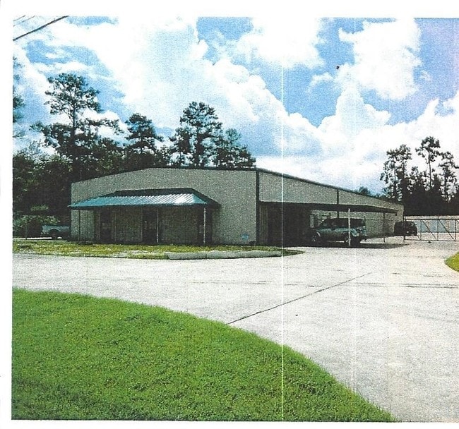
Property Record
23811 Ih 10, Vidor, TX 77662


NEARBY LISTINGS FOR SALE OR LEASE
-
-
View all Vidor listings for lease on LoopNet.com
Property Detail
23811 Ih 10
000029-001721
Abst 29 James Armstrong
Commercialnec
ABST. 29 J. ARMSTRONG TR 018A
AE
Orange
48361C0110D
Texas
0
1.58 AC
2025
Orange County
022000
Beaumont/Port Arthur
3,200 SF
Beaumont-Port Arthur, TX
DEMOGRAPHICS near 23811 Ih 10
1 Mile
3 Mile
5 Mile
2024 Total Population
402
5,502
54,966
2029 Population
413
5,619
54,784
Pop Growth 2024-2029
+ 2.74%
+ 2.13%
(0.33%)
Average Age
42
40
38
2024 Total Households
173
2,185
20,732
HH Growth 2024-2029
+ 2.31%
+ 2.24%
(0.31%)
Median Household Inc
$41,944
$55,480
$43,784
Avg Household Size
2.30
2.40
2.50
2024 Avg HH Vehicles
2.00
2.00
2.00
Median Home Value
$83,116
$79,659
$86,951
Median Year Built
1991
1978
1972
Nearby Places
Map Layers
Map Styles
 Street
 Aerial
- Restaurants
- Banks
- Shops
- Fitness
- Groceries
PUBLIC TRANSPORTATION
COMMUTER RAIL
Beaumont Amtrak (Sunset Limited - Amtrak)
DRIVE
WALK
Distance
Beaumont Amtrak (Sunset Limited - Amtrak)
12 min
7.8 mi
Freight Ports
Port Beaumont
DRIVE
WALK
Distance
Port Beaumont
9 min
5.5 mi
SALE & LEASE HISTORY
LISTING DATE
SALE/LEASE

Sep 23, 2016
For Sale
May 22, 2019
For Sale
Jul 20, 2021
For Lease
Jan 07, 2020
For Sale
Nearby Properties
Address
Land Use
TOTAL SIZE
Lot Size
Zoning
Address
Land Use
TOTAL SIZE
Lot Size
Zoning
425,204 SF
6.99 AC
Address
Land Use
TOTAL SIZE
Lot Size
Zoning
2.07 AC
Address
Land Use
TOTAL SIZE
Lot Size
Zoning
241,242 SF
24.31 AC
Address
Land Use
TOTAL SIZE
Lot Size
Zoning
70.66 AC
Address
Land Use
TOTAL SIZE
Lot Size
Zoning
2.07 AC
Address
Land Use
TOTAL SIZE
Lot Size
Zoning
14,400 SF
1.79 AC
Address
Land Use
TOTAL SIZE
Lot Size
Zoning
109,155 SF
4.55 AC
Address
Land Use
TOTAL SIZE
Lot Size
Zoning
27,344 SF
1.57 AC
Address
Land Use
TOTAL SIZE
Lot Size
Zoning
26,820 SF
2.07 AC
Address
Land Use
TOTAL SIZE
Lot Size
Zoning
2.07 AC
Address
Land Use
TOTAL SIZE
Lot Size
Zoning
62,892 SF
13.17 AC
Address
Land Use
TOTAL SIZE
Lot Size
Zoning
53,212 SF
27.78 AC
Address
Land Use
TOTAL SIZE
Lot Size
Zoning
178,800 SF
0.36 AC
Address
Land Use
TOTAL SIZE
Lot Size
Zoning
107,775 SF
2.66 AC
Address
Land Use
TOTAL SIZE
Lot Size
Zoning
32.96 AC
Address
Land Use
TOTAL SIZE
Lot Size
Zoning
35,320 SF
2.87 AC
Address
Land Use
TOTAL SIZE
Lot Size
Zoning
1,700 SF
190.22 AC
Address
Land Use
TOTAL SIZE
Lot Size
Zoning
23,700 SF
3.99 AC
Address
Land Use
TOTAL SIZE
Lot Size
Zoning
16,211 SF
6.18 AC
Address
Land Use
TOTAL SIZE
Lot Size
Zoning
19,157 SF
2.28 AC
Address
Land Use
TOTAL SIZE
Lot Size
Zoning
8,530 SF
23.82 AC
Address
Land Use
TOTAL SIZE
Lot Size
Zoning
138,766 SF
0.67 AC
Address
Land Use
TOTAL SIZE
Lot Size
Zoning
64,263 SF
0.91 AC
Address
Land Use
TOTAL SIZE
Lot Size
Zoning
18,000 SF
1 AC
Address
Land Use
TOTAL SIZE
Lot Size
Zoning
14,400 SF
1.09 AC
Address
Land Use
TOTAL SIZE
Lot Size
Zoning
12.89 AC
Address
Land Use
TOTAL SIZE
Lot Size
Zoning
33,600 SF
0.83 AC
Address
Land Use
TOTAL SIZE
Lot Size
Zoning
29,500 SF
3.60 AC
Address
Land Use
TOTAL SIZE
Lot Size
Zoning
10,840 SF
5.17 AC
Address
Land Use
TOTAL SIZE
Lot Size
Zoning
21,600 SF
0.66 AC
The World's #1 Commercial Real Estate Marketplace
Connect with us
© 2026 CoStar Group
The information above has been obtained from sources believed reliable. While we do not doubt its accuracy we have not verified it and make no guarantee, warranty or representation about it. It is your responsibility to independently confirm its accuracy and completeness. Any projections, opinions, assumptions, or estimates used are for example only and do not represent the current or future performance of the property. The value of this transaction to you depends on tax and other factors which should be evaluated by your tax, financial, and legal advisors. You and your advisors should conduct a careful, independent investigation of the property to determine to your satisfaction the suitability of the property for your needs.