Property Record
177 E Baffert Dr, Nogales, AZ 85621

Save to a Folder
{{folder.Name}}
{{folder.ListingIds.length}} Properties
{{folder.ListingIds.length}} Property
Create a New Folder
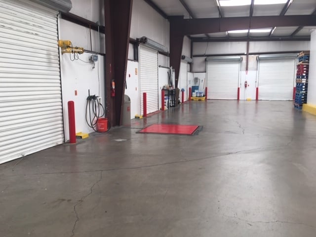
Property Detail
177 E Baffert Dr
102-01-071
A PORTION OF LAND IN THE SE4 NE4 OF SEC 5 T24S R14E
Warehouse
Santa Cruz
AE The base floodplain where base flood elevations are provided. AE Zones are now used on new format FIRMs instead of A1-A30 Zones.
Arizona
2025
3.21 AC
2026
Arizona SE & Sierra Vista Area
966301
Other Market Areas
3,045 SF
Nogales, AZ
NEARBY LISTINGS FOR SALE OR LEASE
-
-
View all Nogales listings for lease on LoopNet.com
DEMOGRAPHICS near 177 E Baffert Dr
1 mile
3 mile
5 mile
2025 Total Population
4,461
23,096
25,914
2030 Population
4,727
24,823
27,812
Pop Growth 2025-2030
+ 5.96%
+ 7.48%
+ 7.32%
Average Age
40
40
40
2025 Total Households
1,461
8,115
9,020
HH Growth 2025-2030
+ 5.89%
+ 7.58%
+ 7.45%
Median Household Inc
$41,849
$40,726
$42,468
Avg Household Size
2.90
2.80
2.80
2025 Avg HH Vehicles
2.00
2.00
2.00
Median Home Value
$185,982
$182,619
$192,492
Median Year Built
1976
1977
1978
Nearby Places
Map Layers
Map Styles
 Street
 Aerial
Layers
 Traffic
 Biking
Places
Listings with unknown addresses are not visible on the map
- Restaurants
- Banks
- Shops
- Fitness
- Groceries
SALE & LEASE HISTORY
LISTING DATE
SALE/LEASE

Oct 08, 2021
For Lease
Aug 08, 2023
For Lease
Nearby Properties
Address
Land Use
TOTAL SIZE
Lot Size
Zoning
Address
Land Use
TOTAL SIZE
Lot Size
Zoning
0.21 AC
Address
Land Use
TOTAL SIZE
Lot Size
Zoning
38,328 SF
94.80 AC
Address
Land Use
TOTAL SIZE
Lot Size
Zoning
149,179 SF
64.65 AC
Address
Land Use
TOTAL SIZE
Lot Size
Zoning
183,703 SF
17.11 AC
Address
Land Use
TOTAL SIZE
Lot Size
Zoning
414,855 SF
23.51 AC
Address
Land Use
TOTAL SIZE
Lot Size
Zoning
46,683 SF
20.31 AC
Address
Land Use
TOTAL SIZE
Lot Size
Zoning
159,143 SF
10.89 AC
Address
Land Use
TOTAL SIZE
Lot Size
Zoning
98,007 SF
16.52 AC
Address
Land Use
TOTAL SIZE
Lot Size
Zoning
21,666 SF
7.76 AC
Address
Land Use
TOTAL SIZE
Lot Size
Zoning
48,542 SF
34.35 AC
Address
Land Use
TOTAL SIZE
Lot Size
Zoning
27,835 SF
10.55 AC
Address
Land Use
TOTAL SIZE
Lot Size
Zoning
Address
Land Use
TOTAL SIZE
Lot Size
Zoning
119,309 SF
9.70 AC
Address
Land Use
TOTAL SIZE
Lot Size
Zoning
188,992 SF
7.27 AC
Address
Land Use
TOTAL SIZE
Lot Size
Zoning
203,600 SF
11.35 AC
Address
Land Use
TOTAL SIZE
Lot Size
Zoning
89,356 SF
6.16 AC
Address
Land Use
TOTAL SIZE
Lot Size
Zoning
2,565 SF
23.36 AC
Address
Land Use
TOTAL SIZE
Lot Size
Zoning
116,163 SF
5.07 AC
Address
Land Use
TOTAL SIZE
Lot Size
Zoning
33,744 SF
8.73 AC
Address
Land Use
TOTAL SIZE
Lot Size
Zoning
111,544 SF
92.88 AC
Address
Land Use
TOTAL SIZE
Lot Size
Zoning
14,502 SF
9.14 AC
Address
Land Use
TOTAL SIZE
Lot Size
Zoning
7,227 SF
0.38 AC
Address
Land Use
TOTAL SIZE
Lot Size
Zoning
214,045 SF
7.67 AC
Address
Land Use
TOTAL SIZE
Lot Size
Zoning
8,665 SF
4.31 AC
Address
Land Use
TOTAL SIZE
Lot Size
Zoning
34,203 SF
19.98 AC
Address
Land Use
TOTAL SIZE
Lot Size
Zoning
141,279 SF
2.82 AC
Address
Land Use
TOTAL SIZE
Lot Size
Zoning
55,140 SF
8.54 AC
Address
Land Use
TOTAL SIZE
Lot Size
Zoning
8,458 SF
10.10 AC
Address
Land Use
TOTAL SIZE
Lot Size
Zoning
57,796 SF
19.09 AC
Address
Land Use
TOTAL SIZE
Lot Size
Zoning
51,049 SF
2.25 AC
The World's #1 Commercial Real Estate Marketplace
Connect with us
© 2026 CoStar Group
The information above has been obtained from sources believed reliable. While we do not doubt its accuracy we have not verified it and make no guarantee, warranty or representation about it. It is your responsibility to independently confirm its accuracy and completeness. Any projections, opinions, assumptions, or estimates used are for example only and do not represent the current or future performance of the property. The value of this transaction to you depends on tax and other factors which should be evaluated by your tax, financial, and legal advisors. You and your advisors should conduct a careful, independent investigation of the property to determine to your satisfaction the suitability of the property for your needs.