Property Record
177 E Kasson Rd, Maple City, MI 49664


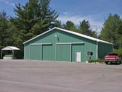
Property Detail
177 E Kasson Rd
007-023-004-60
L428 P724/96 L565 P666/01 L834 P703/04(REF L794 P579) 2009 DESCR REVISED (REF: SPLIT 007-023-004-70)
Commercialnec
Leelanau
B and X Area of moderate flood hazard, usually the area between the limits of the 100-year and 500-year floods.
Michigan
2025
2.58 AC
2026
Other Market Areas
970502
Traverse City, MI
8,352 SF
NEARBY LISTINGS FOR SALE OR LEASE
-
-
View all Maple City listings for sale on LoopNet.com
DEMOGRAPHICS near 177 E Kasson Rd
1 mile
3 mile
5 mile
2025 Total Population
83
939
5,467
2030 Population
89
939
5,484
Pop Growth 2025-2030
+ 7.23%
0.00%
+ 0.31%
Average Age
46
44
44
2025 Total Households
32
375
2,143
HH Growth 2025-2030
+ 6.25%
(0.27%)
+ 0.09%
Median Household Inc
$73,124
$77,344
$83,119
Avg Household Size
2.50
2.40
2.50
2025 Avg HH Vehicles
2.00
2.00
2.00
Median Home Value
$391,666
$342,424
$349,404
Median Year Built
2005
1993
1994
Nearby Places
Map Layers
Map Styles
 Street
 Aerial
Layers
 Traffic
 Biking
Places
Listings with unknown addresses are not visible on the map
- Restaurants
- Banks
- Shops
- Fitness
- Groceries
PUBLIC TRANSPORTATION
AIRPORT
Cherry Capital
Drive
Walk
Distance
Cherry Capital
32 min
16.8 mi
Nearby Properties
Address
Land Use
TOTAL SIZE
Lot Size
Zoning
Address
Land Use
TOTAL SIZE
Lot Size
Zoning
5,816 SF
158.43 AC
Address
Land Use
TOTAL SIZE
Lot Size
Zoning
200.34 AC
Address
Land Use
TOTAL SIZE
Lot Size
Zoning
1,912 SF
160 AC
Address
Land Use
TOTAL SIZE
Lot Size
Zoning
540 SF
188 AC
Address
Land Use
TOTAL SIZE
Lot Size
Zoning
1,152 SF
160 AC
Address
Land Use
TOTAL SIZE
Lot Size
Zoning
2,782 SF
160 AC
Address
Land Use
TOTAL SIZE
Lot Size
Zoning
2,149 SF
159 AC
Address
Land Use
TOTAL SIZE
Lot Size
Zoning
2,624 SF
180 AC
Address
Land Use
TOTAL SIZE
Lot Size
Zoning
5,772 SF
157.02 AC
Address
Land Use
TOTAL SIZE
Lot Size
Zoning
159.50 AC
Address
Land Use
TOTAL SIZE
Lot Size
Zoning
2,382 SF
77.78 AC
Address
Land Use
TOTAL SIZE
Lot Size
Zoning
2,520 SF
80 AC
Address
Land Use
TOTAL SIZE
Lot Size
Zoning
161.25 AC
Address
Land Use
TOTAL SIZE
Lot Size
Zoning
7,770 SF
70 AC
Address
Land Use
TOTAL SIZE
Lot Size
Zoning
2,632 SF
78 AC
Address
Land Use
TOTAL SIZE
Lot Size
Zoning
77.21 AC
Address
Land Use
TOTAL SIZE
Lot Size
Zoning
Address
Land Use
TOTAL SIZE
Lot Size
Zoning
2,798 SF
53 AC
Address
Land Use
TOTAL SIZE
Lot Size
Zoning
1,929 SF
80 AC
Address
Land Use
TOTAL SIZE
Lot Size
Zoning
Address
Land Use
TOTAL SIZE
Lot Size
Zoning
2,320 SF
110.91 AC
Address
Land Use
TOTAL SIZE
Lot Size
Zoning
75.21 AC
Address
Land Use
TOTAL SIZE
Lot Size
Zoning
1,056 SF
11.23 AC
Address
Land Use
TOTAL SIZE
Lot Size
Zoning
107.79 AC
Address
Land Use
TOTAL SIZE
Lot Size
Zoning
1,040 SF
89.68 AC
Address
Land Use
TOTAL SIZE
Lot Size
Zoning
1,588 SF
79.10 AC
Address
Land Use
TOTAL SIZE
Lot Size
Zoning
Address
Land Use
TOTAL SIZE
Lot Size
Zoning
6,326 SF
70.54 AC
Address
Land Use
TOTAL SIZE
Lot Size
Zoning
1,144 SF
73.83 AC
Address
Land Use
TOTAL SIZE
Lot Size
Zoning
73.81 AC
The World's #1 Commercial Real Estate Marketplace
Connect with us
© 2026 CoStar Group
The information above has been obtained from sources believed reliable. While we do not doubt its accuracy we have not verified it and make no guarantee, warranty or representation about it. It is your responsibility to independently confirm its accuracy and completeness. Any projections, opinions, assumptions, or estimates used are for example only and do not represent the current or future performance of the property. The value of this transaction to you depends on tax and other factors which should be evaluated by your tax, financial, and legal advisors. You and your advisors should conduct a careful, independent investigation of the property to determine to your satisfaction the suitability of the property for your needs.