Property Record
177 S Plank Rd, Newburgh, NY 12550
NEARBY LISTINGS FOR SALE OR LEASE
Property Detail
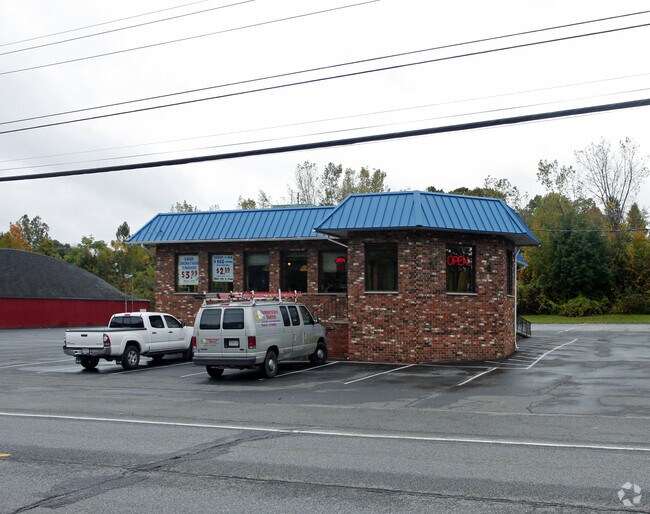
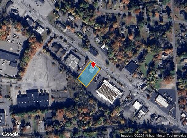
177 S Plank Rd
334600-060-000-0003-014.300-0000
LT 1 CFKS ASSOC MAP 5813
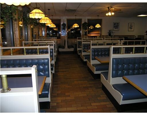
Restaurantbuilding
Orange
AE
New York
36111C0900F
14.30
2024
0.59 AC
2024
Newburgh
010400
Northern New Jersey
3,988 SF
New York-Jersey City-White Plains, NY-NJ
DEMOGRAPHICS near 177 S Plank Rd
1 Mile
3 Mile
5 Mile
2024 Total Population
5,027
39,517
93,435
2029 Population
5,137
40,125
95,194
Pop Growth 2024-2029
+ 2.19%
+ 1.54%
+ 1.88%
Average Age
41
39
39
2024 Total Households
1,860
14,060
34,631
HH Growth 2024-2029
+ 2.20%
+ 1.62%
+ 1.99%
Median Household Inc
$99,629
$83,277
$81,273
Avg Household Size
2.60
2.70
2.60
2024 Avg HH Vehicles
2.00
2.00
2.00
Median Home Value
$267,540
$269,877
$292,645
Median Year Built
1966
1964
1968
Nearby Places
- Restaurants
- Banks
- Shops
- Fitness
- Groceries
PUBLIC TRANSPORTATION
COMMUTER RAIL
Beacon Station (Hudson Line - Metro-North Commuter Railroad Company (Metro-North))
DRIVE
WALK
Distance
Beacon Station (Hudson Line - Metro-North Commuter Railroad Company (Metro-North))
11 min
6.5 mi
Salisbury Mills Cornwall (Bergen County/Port Jervis Line - NJ Transit Commuter Rail (NJ Transit), Main/Port Jervis Line - NJ Transit Commuter Rail (NJ Transit))
DRIVE
WALK
Distance
Salisbury Mills Cornwall (Bergen County/Port Jervis Line - NJ Transit Commuter Rail (NJ Transit), Main/Port Jervis Line - NJ Transit Commuter Rail (NJ Transit))
17 min
8.9 mi
AIRPORT
New York Stewart International
DRIVE
WALK
Distance
New York Stewart International
12 min
5.7 mi
Freight Ports
Port Newark Container Terminal
DRIVE
WALK
Distance
Port Newark Container Terminal
90 min
68.2 mi
Nearby Properties
Address
Land Use
TOTAL SIZE
Lot Size
Zoning
Address
Land Use
TOTAL SIZE
Lot Size
Zoning
355,349 SF
28.50 AC
RM
Address
Land Use
TOTAL SIZE
Lot Size
Zoning
345,572 SF
43.80 AC
R-1
Address
Land Use
TOTAL SIZE
Lot Size
Zoning
88,103 SF
32.60 AC
RH
Address
Land Use
TOTAL SIZE
Lot Size
Zoning
927,041 SF
104.37 AC
Address
Land Use
TOTAL SIZE
Lot Size
Zoning
272,943 SF
17 AC
RL
Address
Land Use
TOTAL SIZE
Lot Size
Zoning
110,384 SF
13.10 AC
RM
Address
Land Use
TOTAL SIZE
Lot Size
Zoning
112,136 SF
2.70 AC
RM
Address
Land Use
TOTAL SIZE
Lot Size
Zoning
91,705 SF
1.90 AC
RM
Address
Land Use
TOTAL SIZE
Lot Size
Zoning
130,037 SF
128.80 AC
Address
Land Use
TOTAL SIZE
Lot Size
Zoning
176,680 SF
1.28 AC
RM
Address
Land Use
TOTAL SIZE
Lot Size
Zoning
82,344 SF
1.80 AC
RH
Address
Land Use
TOTAL SIZE
Lot Size
Zoning
59,220 SF
6.40 AC
CD
Address
Land Use
TOTAL SIZE
Lot Size
Zoning
8.50 AC
AP
Address
Land Use
TOTAL SIZE
Lot Size
Zoning
660.70 AC
AP
Address
Land Use
TOTAL SIZE
Lot Size
Zoning
213,521 SF
8 AC
RH
Address
Land Use
TOTAL SIZE
Lot Size
Zoning
739.80 AC
Address
Land Use
TOTAL SIZE
Lot Size
Zoning
94,608 SF
3.90 AC
RH
Address
Land Use
TOTAL SIZE
Lot Size
Zoning
71.72 AC
Address
Land Use
TOTAL SIZE
Lot Size
Zoning
44.50 AC
Address
Land Use
TOTAL SIZE
Lot Size
Zoning
505,577 SF
50.50 AC
Address
Land Use
TOTAL SIZE
Lot Size
Zoning
265,660 SF
24.20 AC
Address
Land Use
TOTAL SIZE
Lot Size
Zoning
229,085 SF
30.90 AC
04
Address
Land Use
TOTAL SIZE
Lot Size
Zoning
110,686 SF
6.50 AC
RH
Address
Land Use
TOTAL SIZE
Lot Size
Zoning
29,935 SF
31.60 AC
04
Address
Land Use
TOTAL SIZE
Lot Size
Zoning
185,409 SF
26.10 AC
Address
Land Use
TOTAL SIZE
Lot Size
Zoning
67,448 SF
6.30 AC
RL
Address
Land Use
TOTAL SIZE
Lot Size
Zoning
90,584 SF
2.60 AC
RH
Address
Land Use
TOTAL SIZE
Lot Size
Zoning
71,379 SF
20.80 AC
Address
Land Use
TOTAL SIZE
Lot Size
Zoning
200,000 SF
13.80 AC
CD
Address
Land Use
TOTAL SIZE
Lot Size
Zoning
97,011 SF
19.70 AC
The World's #1 Commercial Real Estate Marketplace
Connect with us
© 2025 CoStar Group
The information above has been obtained from sources believed reliable. While we do not doubt its accuracy we have not verified it and make no guarantee, warranty or representation about it. It is your responsibility to independently confirm its accuracy and completeness. Any projections, opinions, assumptions, or estimates used are for example only and do not represent the current or future performance of the property. The value of this transaction to you depends on tax and other factors which should be evaluated by your tax, financial, and legal advisors. You and your advisors should conduct a careful, independent investigation of the property to determine to your satisfaction the suitability of the property for your needs.