Property Record
177 W Main St, Springerville, AZ 85938

Property Detail
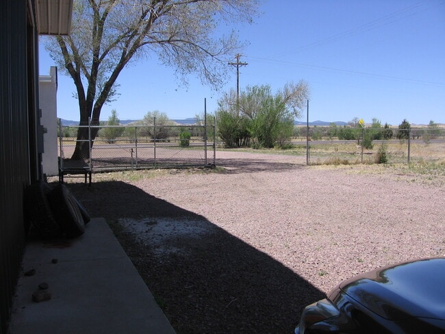
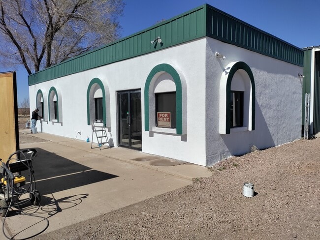
177 W Main St
105-18-004
SECTION: 32 TOWNSHIP: 9N RANGE: 29E IN E2 NE4 208.7X208.7
Storemultistory
Apache
D Areas with possible but undetermined flood hazards.
Arizona
2024
0.93 AC
2026
Arizona Northeast & Holbrook Area
970300
Other Market Areas
1,284 SF
NEARBY LISTINGS FOR SALE OR LEASE
-
-
View all Springerville listings for sale on LoopNet.com
DEMOGRAPHICS near 177 W Main St
1 mile
3 mile
5 mile
2025 Total Population
1,290
5,370
6,473
2030 Population
1,230
5,149
6,208
Pop Growth 2025-2030
(4.65%)
(4.12%)
(4.09%)
Average Age
42
42
42
2025 Total Households
474
2,016
2,464
HH Growth 2025-2030
(5.27%)
(4.37%)
(4.34%)
Median Household Inc
$70,961
$68,453
$69,331
Avg Household Size
2.50
2.60
2.50
2025 Avg HH Vehicles
3.00
2.00
2.00
Median Home Value
$220,349
$240,956
$255,212
Median Year Built
1979
1981
1983
Nearby Places
Map Layers
Map Styles
 Street
 Aerial
Layers
 Traffic
 Biking
Places
Listings with unknown addresses are not visible on the map
- Restaurants
- Banks
- Shops
- Fitness
- Groceries
SALE & LEASE HISTORY
LISTING DATE
SALE/LEASE

Oct 15, 2019
For Lease
Oct 01, 2019
For Sale
May 22, 2022
For Sale
Jul 19, 2023
For Sale
Nearby Properties
Address
Land Use
TOTAL SIZE
Lot Size
Zoning
Address
Land Use
TOTAL SIZE
Lot Size
Zoning
64,026 SF
5.50 AC
Address
Land Use
TOTAL SIZE
Lot Size
Zoning
27,100 SF
2 AC
Address
Land Use
TOTAL SIZE
Lot Size
Zoning
19,089 SF
3.65 AC
Address
Land Use
TOTAL SIZE
Lot Size
Zoning
19,627 SF
3.27 AC
Address
Land Use
TOTAL SIZE
Lot Size
Zoning
18,000 SF
2.36 AC
Address
Land Use
TOTAL SIZE
Lot Size
Zoning
29,172 SF
4.67 AC
Address
Land Use
TOTAL SIZE
Lot Size
Zoning
23,744 SF
6.03 AC
Address
Land Use
TOTAL SIZE
Lot Size
Zoning
25,312 SF
0.72 AC
Address
Land Use
TOTAL SIZE
Lot Size
Zoning
11,406 SF
248 AC
Address
Land Use
TOTAL SIZE
Lot Size
Zoning
8,200 SF
5.70 AC
Address
Land Use
TOTAL SIZE
Lot Size
Zoning
14,991 SF
1.88 AC
Address
Land Use
TOTAL SIZE
Lot Size
Zoning
14,587 SF
1.46 AC
Address
Land Use
TOTAL SIZE
Lot Size
Zoning
53,973 SF
2.94 AC
Address
Land Use
TOTAL SIZE
Lot Size
Zoning
45,090 SF
4.89 AC
Address
Land Use
TOTAL SIZE
Lot Size
Zoning
18,235 SF
1.50 AC
Address
Land Use
TOTAL SIZE
Lot Size
Zoning
18,120 SF
1.41 AC
Address
Land Use
TOTAL SIZE
Lot Size
Zoning
4,704 SF
0.45 AC
Address
Land Use
TOTAL SIZE
Lot Size
Zoning
20,265 SF
1.52 AC
Address
Land Use
TOTAL SIZE
Lot Size
Zoning
14,901 SF
0.63 AC
Address
Land Use
TOTAL SIZE
Lot Size
Zoning
7,696 SF
0.42 AC
Address
Land Use
TOTAL SIZE
Lot Size
Zoning
16,427 SF
1.67 AC
Address
Land Use
TOTAL SIZE
Lot Size
Zoning
7,637 SF
1.13 AC
Address
Land Use
TOTAL SIZE
Lot Size
Zoning
8,098 SF
1.13 AC
Address
Land Use
TOTAL SIZE
Lot Size
Zoning
9,603 SF
1.19 AC
Address
Land Use
TOTAL SIZE
Lot Size
Zoning
31,942 SF
2.01 AC
Address
Land Use
TOTAL SIZE
Lot Size
Zoning
24,423 SF
1.97 AC
Address
Land Use
TOTAL SIZE
Lot Size
Zoning
27,883 SF
3.50 AC
Address
Land Use
TOTAL SIZE
Lot Size
Zoning
7,974 SF
0.56 AC
Address
Land Use
TOTAL SIZE
Lot Size
Zoning
4,169 SF
1.20 AC
Address
Land Use
TOTAL SIZE
Lot Size
Zoning
10,640 SF
1.10 AC
The World's #1 Commercial Real Estate Marketplace
Connect with us
© 2026 CoStar Group
The information above has been obtained from sources believed reliable. While we do not doubt its accuracy we have not verified it and make no guarantee, warranty or representation about it. It is your responsibility to independently confirm its accuracy and completeness. Any projections, opinions, assumptions, or estimates used are for example only and do not represent the current or future performance of the property. The value of this transaction to you depends on tax and other factors which should be evaluated by your tax, financial, and legal advisors. You and your advisors should conduct a careful, independent investigation of the property to determine to your satisfaction the suitability of the property for your needs.