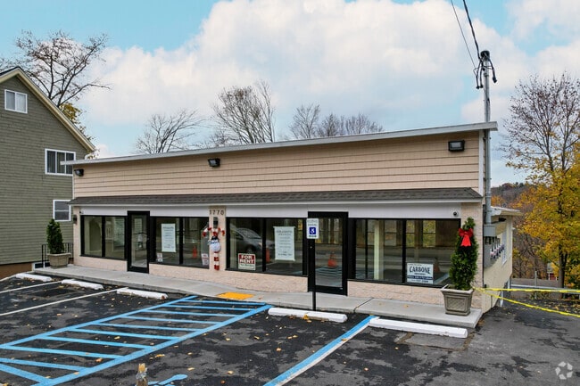
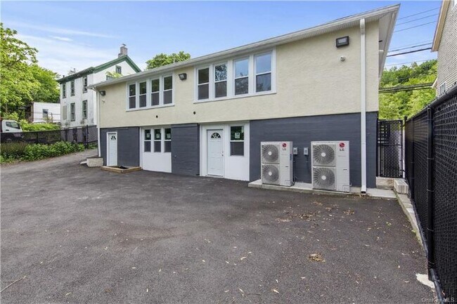
Property Record
1770 Crompond Rd, Peekskill, NY 10566


Property Detail
1770 Crompond Rd
New York-Jersey City-White Plains, NY-NJ
WESTCHESTER
1200-033-006-00020-000-0011
New York
Storesoffices
11.000
B and X Area of moderate flood hazard, usually the area between the limits of the 100-year and 500-year floods.
0.12 AC
2025
Northwest
2025
Westchester/So Connecticut
014300
NEARBY LISTINGS FOR SALE OR LEASE
DEMOGRAPHICS near 1770 Crompond Rd
1 mile
3 mile
5 mile
2025 Total Population
18,846
49,691
81,531
2030 Population
18,964
49,931
81,980
Pop Growth 2025-2030
+ 0.63%
+ 0.48%
+ 0.55%
Average Age
42
42
43
2025 Total Households
7,318
18,044
29,544
HH Growth 2025-2030
+ 0.63%
+ 0.46%
+ 0.43%
Median Household Inc
$99,985
$108,548
$117,024
Avg Household Size
2.50
2.60
2.60
2025 Avg HH Vehicles
2.00
2.00
2.00
Median Home Value
$401,198
$464,272
$494,624
Median Year Built
1965
1963
1963
Nearby Places
Map Layers
Map Styles
 Street
 Aerial
Layers
 Traffic
 Biking
Places
Listings with unknown addresses are not visible on the map
- Restaurants
- Banks
- Shops
- Fitness
- Groceries
PUBLIC TRANSPORTATION
COMMUTER RAIL
Peekskill Station (Hudson Line - Metro-North Commuter Railroad Company (Metro-North))
Drive
Walk
Distance
Peekskill Station (Hudson Line - Metro-North Commuter Railroad Company (Metro-North))
4 min
2.2 mi
Cortlandt Station (Hudson Line - Metro-North Commuter Railroad Company (Metro-North))
Drive
Walk
Distance
Cortlandt Station (Hudson Line - Metro-North Commuter Railroad Company (Metro-North))
11 min
5.3 mi
AIRPORT
New York Stewart International
Drive
Walk
Distance
New York Stewart International
44 min
25.5 mi
Westchester County
Drive
Walk
Distance
Westchester County
38 min
28.3 mi
Freight Ports
NY - Red Hook Container Terminal
Drive
Walk
Distance
NY - Red Hook Container Terminal
81 min
55.7 mi
SALE & LEASE HISTORY
LISTING DATE
SALE/LEASE

Nov 21, 2016
For Sale
Jan 01, 2023
For Sale
Dec 30, 2021
For Lease
Nearby Properties
Address
Land Use
TOTAL SIZE
Lot Size
Zoning
Address
Land Use
TOTAL SIZE
Lot Size
Zoning
Address
Land Use
TOTAL SIZE
Lot Size
Zoning
Address
Land Use
TOTAL SIZE
Lot Size
Zoning
Address
Land Use
TOTAL SIZE
Lot Size
Zoning
157 AC
Address
Land Use
TOTAL SIZE
Lot Size
Zoning
Address
Land Use
TOTAL SIZE
Lot Size
Zoning
Address
Land Use
TOTAL SIZE
Lot Size
Zoning
Address
Land Use
TOTAL SIZE
Lot Size
Zoning
Address
Land Use
TOTAL SIZE
Lot Size
Zoning
Address
Land Use
TOTAL SIZE
Lot Size
Zoning
82.53 AC
Address
Land Use
TOTAL SIZE
Lot Size
Zoning
2.70 AC
Address
Land Use
TOTAL SIZE
Lot Size
Zoning
Address
Land Use
TOTAL SIZE
Lot Size
Zoning
Address
Land Use
TOTAL SIZE
Lot Size
Zoning
22.61 AC
Address
Land Use
TOTAL SIZE
Lot Size
Zoning
8.93 AC
Address
Land Use
TOTAL SIZE
Lot Size
Zoning
2.99 AC
Address
Land Use
TOTAL SIZE
Lot Size
Zoning
Address
Land Use
TOTAL SIZE
Lot Size
Zoning
Address
Land Use
TOTAL SIZE
Lot Size
Zoning
7.50 AC
Address
Land Use
TOTAL SIZE
Lot Size
Zoning
38.05 AC
Address
Land Use
TOTAL SIZE
Lot Size
Zoning
Address
Land Use
TOTAL SIZE
Lot Size
Zoning
9,707 SF
5.51 AC
R80
Address
Land Use
TOTAL SIZE
Lot Size
Zoning
23.27 AC
Address
Land Use
TOTAL SIZE
Lot Size
Zoning
9,498 SF
0.21 AC
R10
Address
Land Use
TOTAL SIZE
Lot Size
Zoning
48.07 AC
Address
Land Use
TOTAL SIZE
Lot Size
Zoning
0.39 AC
Address
Land Use
TOTAL SIZE
Lot Size
Zoning
1,379.36 AC
Address
Land Use
TOTAL SIZE
Lot Size
Zoning
Address
Land Use
TOTAL SIZE
Lot Size
Zoning
8.50 AC
Address
Land Use
TOTAL SIZE
Lot Size
Zoning
35.97 AC
The World's #1 Commercial Real Estate Marketplace
Connect with us
© 2026 CoStar Group
The information above has been obtained from sources believed reliable. While we do not doubt its accuracy we have not verified it and make no guarantee, warranty or representation about it. It is your responsibility to independently confirm its accuracy and completeness. Any projections, opinions, assumptions, or estimates used are for example only and do not represent the current or future performance of the property. The value of this transaction to you depends on tax and other factors which should be evaluated by your tax, financial, and legal advisors. You and your advisors should conduct a careful, independent investigation of the property to determine to your satisfaction the suitability of the property for your needs.