Property Record
17701 Eel River Rd, Potter Valley, CA 95469

NEARBY LISTINGS FOR SALE OR LEASE
-
-
View all Potter Valley listings for sale on LoopNet.com
Property Detail
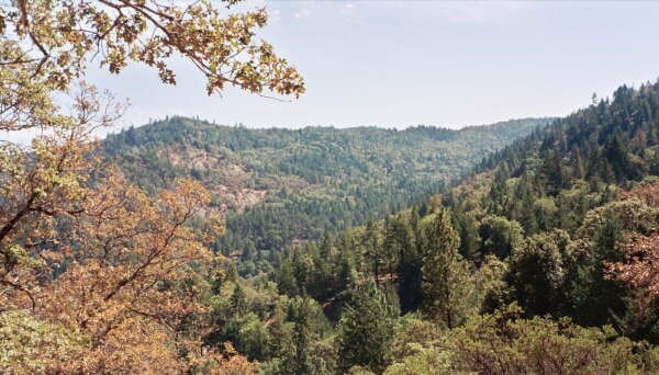
17701 Eel River Rd
173-020-03-00
THE N 1/2 OF THE SE 1/4 AND THE SW 1/4 OF THE SE 1/4 OF SEC 33, T18N, R11W, MDB&M.
Pasture
Mendocino
A
California
06033C0225E
3
2024
120 AC
2025
Other Market Areas
010802
Ukiah, CA
DEMOGRAPHICS near 17701 Eel River Rd
1 Mile
3 Mile
5 Mile
2024 Total Population
184
269
831
2029 Population
172
252
779
Pop Growth 2024-2029
(6.52%)
(6.32%)
(6.26%)
Average Age
45
45
44
2024 Total Households
74
108
319
HH Growth 2024-2029
(5.41%)
(6.48%)
(5.96%)
Median Household Inc
$39,999
$41,500
$55,185
Avg Household Size
2.40
2.50
2.50
2024 Avg HH Vehicles
3.00
3.00
3.00
Median Home Value
$638,889
$634,615
$682,926
Median Year Built
1968
1969
1976
Nearby Places
Map Layers
Map Styles
 Street
 Aerial
- Restaurants
- Banks
- Shops
- Fitness
- Groceries
Nearby Properties
Address
Land Use
TOTAL SIZE
Lot Size
Zoning
Address
Land Use
TOTAL SIZE
Lot Size
Zoning
4,224 SF
139.60 AC
RL160
Address
Land Use
TOTAL SIZE
Lot Size
Zoning
2,436 SF
12.50 AC
AG40
Address
Land Use
TOTAL SIZE
Lot Size
Zoning
36.42 AC
AG40
Address
Land Use
TOTAL SIZE
Lot Size
Zoning
43.82 AC
AG40
Address
Land Use
TOTAL SIZE
Lot Size
Zoning
5,188 SF
45.04 AC
AG40
Address
Land Use
TOTAL SIZE
Lot Size
Zoning
2,400 SF
47.59 AC
RL
Address
Land Use
TOTAL SIZE
Lot Size
Zoning
3,186 SF
18.95 AC
AG40
Address
Land Use
TOTAL SIZE
Lot Size
Zoning
Address
Land Use
TOTAL SIZE
Lot Size
Zoning
58.93 AC
RR
Address
Land Use
TOTAL SIZE
Lot Size
Zoning
5.32 AC
RL160
Address
Land Use
TOTAL SIZE
Lot Size
Zoning
Address
Land Use
TOTAL SIZE
Lot Size
Zoning
2,160 SF
78.50 AC
RL160
Address
Land Use
TOTAL SIZE
Lot Size
Zoning
51.47 AC
AG40
Address
Land Use
TOTAL SIZE
Lot Size
Zoning
7,025 SF
54 AC
AG40
Address
Land Use
TOTAL SIZE
Lot Size
Zoning
3,869 SF
73 AC
RL160
Address
Land Use
TOTAL SIZE
Lot Size
Zoning
1,496 SF
40 AC
AG40
Address
Land Use
TOTAL SIZE
Lot Size
Zoning
10.12 AC
Address
Land Use
TOTAL SIZE
Lot Size
Zoning
4,806 SF
31.74 AC
AG40
Address
Land Use
TOTAL SIZE
Lot Size
Zoning
1,734 SF
34.30 AC
AG40
Address
Land Use
TOTAL SIZE
Lot Size
Zoning
36 AC
AG40
Address
Land Use
TOTAL SIZE
Lot Size
Zoning
80 AC
RL160
Address
Land Use
TOTAL SIZE
Lot Size
Zoning
1,332 SF
20.25 AC
AG40
Address
Land Use
TOTAL SIZE
Lot Size
Zoning
3,455 SF
23.37 AC
RL160
Address
Land Use
TOTAL SIZE
Lot Size
Zoning
6,060 SF
41.44 AC
AG40
Address
Land Use
TOTAL SIZE
Lot Size
Zoning
1,692 SF
75.50 AC
AG40
Address
Land Use
TOTAL SIZE
Lot Size
Zoning
2,428 SF
15.80 AC
AG40
Address
Land Use
TOTAL SIZE
Lot Size
Zoning
1,204 SF
10 AC
AG40
Address
Land Use
TOTAL SIZE
Lot Size
Zoning
15 AC
AG40
Address
Land Use
TOTAL SIZE
Lot Size
Zoning
1,400 SF
6.50 AC
AG40
Address
Land Use
TOTAL SIZE
Lot Size
Zoning
92.30 AC
AG40
The World's #1 Commercial Real Estate Marketplace
Connect with us
© 2026 CoStar Group
The information above has been obtained from sources believed reliable. While we do not doubt its accuracy we have not verified it and make no guarantee, warranty or representation about it. It is your responsibility to independently confirm its accuracy and completeness. Any projections, opinions, assumptions, or estimates used are for example only and do not represent the current or future performance of the property. The value of this transaction to you depends on tax and other factors which should be evaluated by your tax, financial, and legal advisors. You and your advisors should conduct a careful, independent investigation of the property to determine to your satisfaction the suitability of the property for your needs.