Property Record
17712 Nonesuch Rd, Conroe, TX 77306
NEARBY LISTINGS FOR SALE OR LEASE
Property Detail
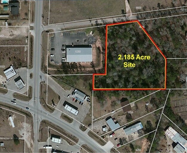
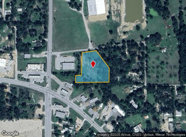
17712 Nonesuch Rd
Houston-Pasadena-The Woodlands, TX
Beach Clark
0079-03-01103
A0079 - BEACH CLARK, TRACT 11-C, ACRES 2.185
Residentialacreage
Montgomery
X
Texas
48339C0575G
2.19 AC
2024
Outlying Montgomery Cnty
2025
Houston
692701
DEMOGRAPHICS near 17712 Nonesuch Rd
1 Mile
3 Mile
5 Mile
2024 Total Population
4,299
12,785
24,269
2029 Population
5,366
15,953
30,112
Pop Growth 2024-2029
+ 24.82%
+ 24.78%
+ 24.08%
Average Age
36
36
37
2024 Total Households
1,340
4,080
7,820
HH Growth 2024-2029
+ 25.00%
+ 24.88%
+ 24.18%
Median Household Inc
$56,521
$59,362
$59,832
Avg Household Size
3.10
3.00
3.00
2024 Avg HH Vehicles
2.00
2.00
2.00
Median Home Value
$97,453
$118,320
$161,482
Median Year Built
2000
2001
1999
Nearby Places
Map Layers
Map Styles
 Street
 Aerial
- Restaurants
- Banks
- Shops
- Fitness
- Groceries
PUBLIC TRANSPORTATION
AIRPORT
George Bush Intcntl/Houston
DRIVE
WALK
Distance
George Bush Intcntl/Houston
36 min
27.6 mi
Freight Ports
Port of Houston
DRIVE
WALK
Distance
Port of Houston
57 min
42.9 mi
Nearby Properties
Address
Land Use
TOTAL SIZE
Lot Size
Zoning
Address
Land Use
TOTAL SIZE
Lot Size
Zoning
305,900 SF
60.85 AC
1
Address
Land Use
TOTAL SIZE
Lot Size
Zoning
205,948 SF
23.14 AC
Address
Land Use
TOTAL SIZE
Lot Size
Zoning
126,871 SF
58.54 AC
1
Address
Land Use
TOTAL SIZE
Lot Size
Zoning
149,817 SF
2 AC
1
Address
Land Use
TOTAL SIZE
Lot Size
Zoning
98,000 SF
18 AC
Address
Land Use
TOTAL SIZE
Lot Size
Zoning
61,000 SF
28.31 AC
Address
Land Use
TOTAL SIZE
Lot Size
Zoning
18,308 SF
2.68 AC
1
Address
Land Use
TOTAL SIZE
Lot Size
Zoning
96,946 SF
12 AC
1
Address
Land Use
TOTAL SIZE
Lot Size
Zoning
61,000 SF
16.10 AC
1
Address
Land Use
TOTAL SIZE
Lot Size
Zoning
6,286 SF
21.84 AC
Address
Land Use
TOTAL SIZE
Lot Size
Zoning
26,558 SF
12 AC
1
Address
Land Use
TOTAL SIZE
Lot Size
Zoning
9,288 SF
1.99 AC
Address
Land Use
TOTAL SIZE
Lot Size
Zoning
9,020 SF
1.54 AC
Address
Land Use
TOTAL SIZE
Lot Size
Zoning
19,952 SF
2 AC
Address
Land Use
TOTAL SIZE
Lot Size
Zoning
8.87 AC
1
Address
Land Use
TOTAL SIZE
Lot Size
Zoning
9,180 SF
1.38 AC
1
Address
Land Use
TOTAL SIZE
Lot Size
Zoning
15,988 SF
46.22 AC
1
Address
Land Use
TOTAL SIZE
Lot Size
Zoning
19,939 SF
1.52 AC
1
Address
Land Use
TOTAL SIZE
Lot Size
Zoning
1,440 SF
12.81 AC
1
Address
Land Use
TOTAL SIZE
Lot Size
Zoning
12,000 SF
1.38 AC
1
Address
Land Use
TOTAL SIZE
Lot Size
Zoning
9,280 SF
4.57 AC
1
Address
Land Use
TOTAL SIZE
Lot Size
Zoning
22,700 SF
7.02 AC
Address
Land Use
TOTAL SIZE
Lot Size
Zoning
12,880 SF
5.86 AC
1
Address
Land Use
TOTAL SIZE
Lot Size
Zoning
8,050 SF
2.84 AC
1
Address
Land Use
TOTAL SIZE
Lot Size
Zoning
14,992 SF
2.27 AC
1
Address
Land Use
TOTAL SIZE
Lot Size
Zoning
6,000 SF
1.25 AC
Address
Land Use
TOTAL SIZE
Lot Size
Zoning
10,560 SF
2 AC
1
Address
Land Use
TOTAL SIZE
Lot Size
Zoning
25,364 SF
6.11 AC
1
Address
Land Use
TOTAL SIZE
Lot Size
Zoning
5,144 SF
2.41 AC
1
Address
Land Use
TOTAL SIZE
Lot Size
Zoning
4,730 SF
2 AC
1
The World's #1 Commercial Real Estate Marketplace
Connect with us
© 2026 CoStar Group
The information above has been obtained from sources believed reliable. While we do not doubt its accuracy we have not verified it and make no guarantee, warranty or representation about it. It is your responsibility to independently confirm its accuracy and completeness. Any projections, opinions, assumptions, or estimates used are for example only and do not represent the current or future performance of the property. The value of this transaction to you depends on tax and other factors which should be evaluated by your tax, financial, and legal advisors. You and your advisors should conduct a careful, independent investigation of the property to determine to your satisfaction the suitability of the property for your needs.