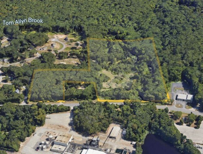
Property Record
1772 Route 12, Gales Ferry, CT 06335

NEARBY LISTINGS FOR SALE OR LEASE
Property Detail
1772 Route 12
LEDY-000061-002120-001772
New London
Taxexempt
Connecticut
X
1772
09011C0354G
1.85 AC
2025
New London
2025
Hartford
701200
Norwich-New London, CT
14,000 SF
DEMOGRAPHICS near 1772 Route 12
1 Mile
3 Mile
5 Mile
2024 Total Population
1,448
15,326
44,873
2029 Population
1,430
15,286
44,730
Pop Growth 2024-2029
(1.24%)
(0.26%)
(0.32%)
Average Age
40
42
39
2024 Total Households
549
5,522
15,920
HH Growth 2024-2029
(1.46%)
(0.62%)
(0.41%)
Median Household Inc
$96,043
$87,357
$80,455
Avg Household Size
2.60
2.50
2.50
2024 Avg HH Vehicles
2.00
2.00
2.00
Median Home Value
$255,957
$246,566
$250,347
Median Year Built
1967
1967
1970
Nearby Places
Map Layers
Map Styles
 Street
 Aerial
- Restaurants
- Banks
- Shops
- Fitness
- Groceries
PUBLIC TRANSPORTATION
COMMUTER RAIL
New London (Shore Line East - Shore Line East)
DRIVE
WALK
Distance
New London (Shore Line East - Shore Line East)
15 min
9.0 mi
Freight Ports
Port of Davisville, RI
DRIVE
WALK
Distance
Port of Davisville, RI
75 min
51.0 mi
SALE & LEASE HISTORY
LISTING DATE
SALE/LEASE

Jul 29, 2022
For Sale
Nearby Properties
Address
Land Use
TOTAL SIZE
Lot Size
Zoning
Address
Land Use
TOTAL SIZE
Lot Size
Zoning
Address
Land Use
TOTAL SIZE
Lot Size
Zoning
4.59 AC
TRDD
Address
Land Use
TOTAL SIZE
Lot Size
Zoning
251.73 AC
RM40
Address
Land Use
TOTAL SIZE
Lot Size
Zoning
113.19 AC
C2/OZ
Address
Land Use
TOTAL SIZE
Lot Size
Zoning
65.90 AC
RSRVT
Address
Land Use
TOTAL SIZE
Lot Size
Zoning
59.03 AC
RSRVT
Address
Land Use
TOTAL SIZE
Lot Size
Zoning
22.87 AC
C-2
Address
Land Use
TOTAL SIZE
Lot Size
Zoning
102,477 SF
22.51 AC
C-2
Address
Land Use
TOTAL SIZE
Lot Size
Zoning
38.30 AC
R40
Address
Land Use
TOTAL SIZE
Lot Size
Zoning
106,807 SF
5.60 AC
C-2
Address
Land Use
TOTAL SIZE
Lot Size
Zoning
35.36 AC
RSRVT
Address
Land Use
TOTAL SIZE
Lot Size
Zoning
23.24 AC
RSRVT
Address
Land Use
TOTAL SIZE
Lot Size
Zoning
6.54 AC
GOV
Address
Land Use
TOTAL SIZE
Lot Size
Zoning
55,562 SF
29.68 AC
GOV
Address
Land Use
TOTAL SIZE
Lot Size
Zoning
34,436 SF
19.52 AC
IND
Address
Land Use
TOTAL SIZE
Lot Size
Zoning
18.90 AC
RSRVT
Address
Land Use
TOTAL SIZE
Lot Size
Zoning
18,015 SF
17.16 AC
GOV
Address
Land Use
TOTAL SIZE
Lot Size
Zoning
450,955 SF
157.97 AC
I
Address
Land Use
TOTAL SIZE
Lot Size
Zoning
46,011 SF
4.96 AC
C-2
Address
Land Use
TOTAL SIZE
Lot Size
Zoning
47,715 SF
3.41 AC
C-2
Address
Land Use
TOTAL SIZE
Lot Size
Zoning
13,677 SF
1.90 AC
GFDD
Address
Land Use
TOTAL SIZE
Lot Size
Zoning
10.46 AC
RSRVT
Address
Land Use
TOTAL SIZE
Lot Size
Zoning
12,950 SF
3.30 AC
C-1
Address
Land Use
TOTAL SIZE
Lot Size
Zoning
12.02 AC
R20-M
Address
Land Use
TOTAL SIZE
Lot Size
Zoning
26,956 SF
2.07 AC
C-1
Address
Land Use
TOTAL SIZE
Lot Size
Zoning
4.77 AC
R20
Address
Land Use
TOTAL SIZE
Lot Size
Zoning
11.89 AC
GFDD
Address
Land Use
TOTAL SIZE
Lot Size
Zoning
16.58 AC
GOV
Address
Land Use
TOTAL SIZE
Lot Size
Zoning
6.23 AC
CIP
Address
Land Use
TOTAL SIZE
Lot Size
Zoning
5.89 AC
RSRVT
The World's #1 Commercial Real Estate Marketplace
Connect with us
© 2026 CoStar Group
The information above has been obtained from sources believed reliable. While we do not doubt its accuracy we have not verified it and make no guarantee, warranty or representation about it. It is your responsibility to independently confirm its accuracy and completeness. Any projections, opinions, assumptions, or estimates used are for example only and do not represent the current or future performance of the property. The value of this transaction to you depends on tax and other factors which should be evaluated by your tax, financial, and legal advisors. You and your advisors should conduct a careful, independent investigation of the property to determine to your satisfaction the suitability of the property for your needs.