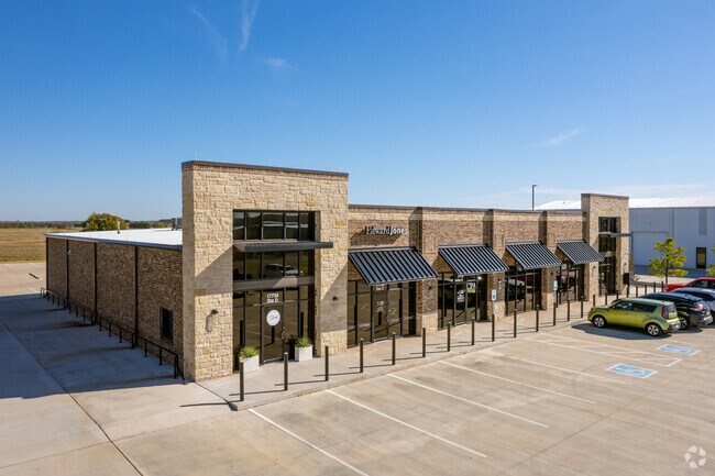
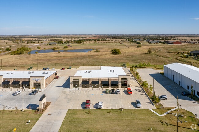
Property Record
17730 Macarthur Park Rd, Edmond, OK 73012

NEARBY LISTINGS FOR SALE OR LEASE
Property Detail
17730 Macarthur Park Rd
Oklahoma City, OK
Mayflower Market
215521020
MAYFLOWER MARKET BLK 001 LOT 003
Regionalshoppingcenterormallwithanchorstore
Oklahoma
X
Oklahoma
40083C0500F
003
2023
1.02 AC
2024
North Outlying
108233
Oklahoma City
10,725 SF
DEMOGRAPHICS near 17730 Macarthur Park Rd
1 Mile
3 Mile
5 Mile
2024 Total Population
717
22,713
102,631
2029 Population
744
23,795
106,860
Pop Growth 2024-2029
+ 3.77%
+ 4.76%
+ 4.12%
Average Age
39
34
37
2024 Total Households
235
8,208
41,005
HH Growth 2024-2029
+ 3.83%
+ 4.89%
+ 4.02%
Median Household Inc
$159,183
$121,719
$92,061
Avg Household Size
3.10
2.70
2.40
2024 Avg HH Vehicles
3.00
2.00
2.00
Median Home Value
$456,034
$295,177
$274,487
Median Year Built
2005
2010
2002
Nearby Places
Map Layers
Map Styles
 Street
 Aerial
- Restaurants
- Banks
- Shops
- Fitness
- Groceries
PUBLIC TRANSPORTATION
AIRPORT
Will Rogers World
DRIVE
WALK
Distance
Will Rogers World
34 min
21.6 mi
Freight Ports
Tulsa Port Of Catoosa
DRIVE
WALK
Distance
Tulsa Port Of Catoosa
137 min
125.7 mi
SALE & LEASE HISTORY
LISTING DATE
SALE/LEASE

May 12, 2023
For Lease
Mar 10, 2020
For Lease
Nearby Properties
Address
Land Use
TOTAL SIZE
Lot Size
Zoning
Address
Land Use
TOTAL SIZE
Lot Size
Zoning
60,267 SF
0.88 AC
C-3
Address
Land Use
TOTAL SIZE
Lot Size
Zoning
414,006 SF
22.80 AC
PUD
Address
Land Use
TOTAL SIZE
Lot Size
Zoning
333,436 SF
22.82 AC
PUD
Address
Land Use
TOTAL SIZE
Lot Size
Zoning
10,635 SF
1.49 AC
PUD
Address
Land Use
TOTAL SIZE
Lot Size
Zoning
302,058 SF
23.78 AC
PUD
Address
Land Use
TOTAL SIZE
Lot Size
Zoning
64,931 SF
6.44 AC
PUD
Address
Land Use
TOTAL SIZE
Lot Size
Zoning
0.19 AC
LCR320U*
Address
Land Use
TOTAL SIZE
Lot Size
Zoning
101,883 SF
4.42 AC
PUD
Address
Land Use
TOTAL SIZE
Lot Size
Zoning
6,372 SF
0.57 AC
Address
Land Use
TOTAL SIZE
Lot Size
Zoning
61,914 SF
7.08 AC
PUD
Address
Land Use
TOTAL SIZE
Lot Size
Zoning
73,500 SF
9.93 AC
PUD
Address
Land Use
TOTAL SIZE
Lot Size
Zoning
56,170 SF
2.66 AC
PUD
Address
Land Use
TOTAL SIZE
Lot Size
Zoning
36,436 SF
2.16 AC
PUD
Address
Land Use
TOTAL SIZE
Lot Size
Zoning
38,382 SF
2.52 AC
PUD
Address
Land Use
TOTAL SIZE
Lot Size
Zoning
38,932 SF
1.93 AC
PUD
Address
Land Use
TOTAL SIZE
Lot Size
Zoning
81,522 SF
5.07 AC
PUD
Address
Land Use
TOTAL SIZE
Lot Size
Zoning
88,085 SF
15.41 AC
PUD
Address
Land Use
TOTAL SIZE
Lot Size
Zoning
35,202 SF
4.08 AC
Address
Land Use
TOTAL SIZE
Lot Size
Zoning
60,223 SF
13.17 AC
PUD
Address
Land Use
TOTAL SIZE
Lot Size
Zoning
90,228 SF
10.47 AC
PUD
Address
Land Use
TOTAL SIZE
Lot Size
Zoning
35,317 SF
1.74 AC
PUD
Address
Land Use
TOTAL SIZE
Lot Size
Zoning
11,679 SF
258.81 AC
Address
Land Use
TOTAL SIZE
Lot Size
Zoning
17,551 SF
3.44 AC
PUD
Address
Land Use
TOTAL SIZE
Lot Size
Zoning
8,423 SF
2.55 AC
PUD
Address
Land Use
TOTAL SIZE
Lot Size
Zoning
86,910 SF
27.44 AC
AA
Address
Land Use
TOTAL SIZE
Lot Size
Zoning
113,884 SF
13.42 AC
Address
Land Use
TOTAL SIZE
Lot Size
Zoning
74.52 AC
R-1
Address
Land Use
TOTAL SIZE
Lot Size
Zoning
82,993 SF
70.10 AC
I-2
Address
Land Use
TOTAL SIZE
Lot Size
Zoning
60,280 SF
3.33 AC
PUD
The World's #1 Commercial Real Estate Marketplace
Connect with us
© 2025 CoStar Group
The information above has been obtained from sources believed reliable. While we do not doubt its accuracy we have not verified it and make no guarantee, warranty or representation about it. It is your responsibility to independently confirm its accuracy and completeness. Any projections, opinions, assumptions, or estimates used are for example only and do not represent the current or future performance of the property. The value of this transaction to you depends on tax and other factors which should be evaluated by your tax, financial, and legal advisors. You and your advisors should conduct a careful, independent investigation of the property to determine to your satisfaction the suitability of the property for your needs.