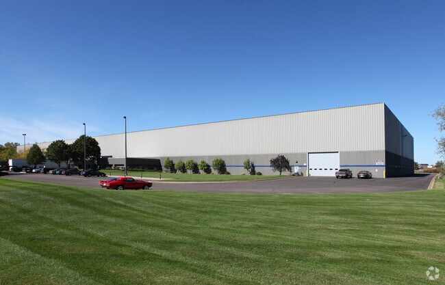
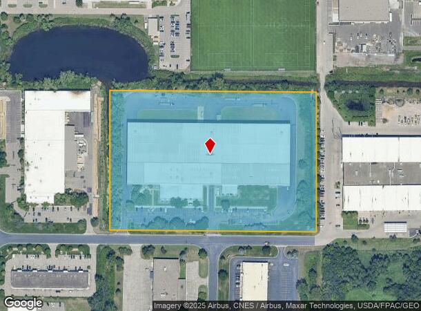
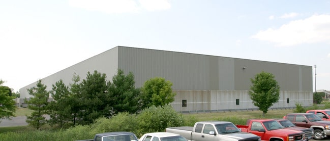
Property Record
1775 101St Ave Ne, Minneapolis, MN 55449
NEARBY LISTINGS FOR SALE OR LEASE
Property Detail
1775 101St Ave Ne
20-31-23-44-0003
Lakes Add 04
Industrialgeneral
THE S 600 FT OF E 830 FT OF SE1/4 OF SE1/4 OF SEC 20 TWP 31 RGE 23, EX RD, SUBJ TO EASE OF REC
A
Anoka
27003C0338E
Minnesota
2024
10.70 AC
2025
North Central
050829
Minneapolis/St Paul
168,694 SF
Minneapolis-St. Paul-Bloomington, MN-WI
DEMOGRAPHICS near 1775 101St Ave Ne
1 Mile
3 Mile
5 Mile
2024 Total Population
3,211
67,188
180,061
2029 Population
3,311
69,760
185,513
Pop Growth 2024-2029
+ 3.11%
+ 3.83%
+ 3.03%
Average Age
40
39
39
2024 Total Households
1,344
25,097
67,004
HH Growth 2024-2029
+ 3.13%
+ 3.83%
+ 2.96%
Median Household Inc
$63,668
$86,319
$86,127
Avg Household Size
2.30
2.60
2.60
2024 Avg HH Vehicles
2.00
2.00
2.00
Median Home Value
$168,303
$266,492
$276,212
Median Year Built
1991
1988
1984
Nearby Places
Map Layers
Map Styles
 Street
 Aerial
- Restaurants
- Banks
- Shops
- Fitness
- Groceries
PUBLIC TRANSPORTATION
COMMUTER RAIL
Fridley Station (Northstar Corridor - Northstar Commuter Rail)
DRIVE
WALK
Distance
Fridley Station (Northstar Corridor - Northstar Commuter Rail)
14 min
7.3 mi
Coon Rapids-Riverdale Station (Northstar Corridor - Northstar Commuter Rail)
DRIVE
WALK
Distance
Coon Rapids-Riverdale Station (Northstar Corridor - Northstar Commuter Rail)
15 min
9.6 mi
AIRPORT
Minneapolis-St Paul International/Wold-Chamberlain
DRIVE
WALK
Distance
Minneapolis-St Paul International/Wold-Chamberlain
40 min
27.8 mi
Nearby Properties
Address
Land Use
TOTAL SIZE
Lot Size
Zoning
Address
Land Use
TOTAL SIZE
Lot Size
Zoning
2,443,869 SF
31.79 AC
Address
Land Use
TOTAL SIZE
Lot Size
Zoning
100,260 SF
74.82 AC
Address
Land Use
TOTAL SIZE
Lot Size
Zoning
35,488 SF
39.07 AC
Address
Land Use
TOTAL SIZE
Lot Size
Zoning
239,389 SF
5.73 AC
Address
Land Use
TOTAL SIZE
Lot Size
Zoning
229,420 SF
4.14 AC
Address
Land Use
TOTAL SIZE
Lot Size
Zoning
214,300 SF
9.15 AC
Address
Land Use
TOTAL SIZE
Lot Size
Zoning
195,000 SF
Address
Land Use
TOTAL SIZE
Lot Size
Zoning
8,400 SF
10.10 AC
Address
Land Use
TOTAL SIZE
Lot Size
Zoning
Address
Land Use
TOTAL SIZE
Lot Size
Zoning
225,576 SF
6.07 AC
Address
Land Use
TOTAL SIZE
Lot Size
Zoning
208 SF
228 AC
Address
Land Use
TOTAL SIZE
Lot Size
Zoning
14,908 SF
28.38 AC
Address
Land Use
TOTAL SIZE
Lot Size
Zoning
342,686 SF
13.60 AC
Address
Land Use
TOTAL SIZE
Lot Size
Zoning
248,816 SF
14.02 AC
Address
Land Use
TOTAL SIZE
Lot Size
Zoning
192 SF
11.30 AC
Address
Land Use
TOTAL SIZE
Lot Size
Zoning
105,324 SF
13.36 AC
Address
Land Use
TOTAL SIZE
Lot Size
Zoning
76,383 SF
7.60 AC
Address
Land Use
TOTAL SIZE
Lot Size
Zoning
190,377 SF
9.61 AC
Address
Land Use
TOTAL SIZE
Lot Size
Zoning
98,642 SF
20.01 AC
Address
Land Use
TOTAL SIZE
Lot Size
Zoning
119,907 SF
36.99 AC
Address
Land Use
TOTAL SIZE
Lot Size
Zoning
61,740 SF
16.10 AC
Address
Land Use
TOTAL SIZE
Lot Size
Zoning
122,498 SF
31.67 AC
Address
Land Use
TOTAL SIZE
Lot Size
Zoning
77,940 SF
19.07 AC
Address
Land Use
TOTAL SIZE
Lot Size
Zoning
262,452 SF
Address
Land Use
TOTAL SIZE
Lot Size
Zoning
135,746 SF
8.85 AC
Address
Land Use
TOTAL SIZE
Lot Size
Zoning
162,450 SF
9.97 AC
Address
Land Use
TOTAL SIZE
Lot Size
Zoning
287,568 SF
8.01 AC
Address
Land Use
TOTAL SIZE
Lot Size
Zoning
83,688 SF
5.75 AC
Address
Land Use
TOTAL SIZE
Lot Size
Zoning
179,523 SF
16.58 AC
Address
Land Use
TOTAL SIZE
Lot Size
Zoning
112,500 SF
7.55 AC
The World's #1 Commercial Real Estate Marketplace
Connect with us
© 2026 CoStar Group
The information above has been obtained from sources believed reliable. While we do not doubt its accuracy we have not verified it and make no guarantee, warranty or representation about it. It is your responsibility to independently confirm its accuracy and completeness. Any projections, opinions, assumptions, or estimates used are for example only and do not represent the current or future performance of the property. The value of this transaction to you depends on tax and other factors which should be evaluated by your tax, financial, and legal advisors. You and your advisors should conduct a careful, independent investigation of the property to determine to your satisfaction the suitability of the property for your needs.