Property Record
1775 Foundation Dr, Niles, MI 49120
NEARBY LISTINGS FOR SALE OR LEASE
-
-
View all Niles listings for sale on LoopNet.com
Property Detail
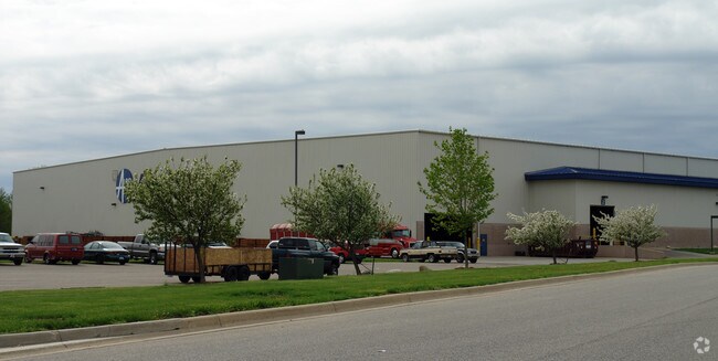
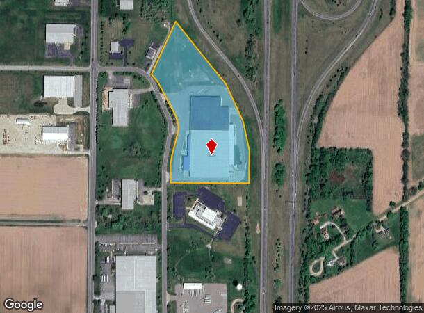
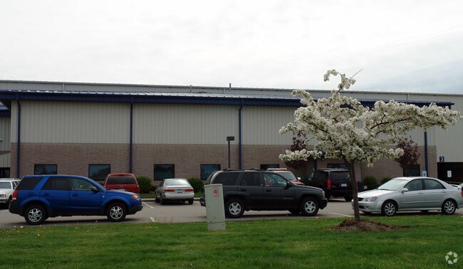
1775 Foundation Dr
11-05-0105-0008-10-4
COM AT SW COR SEC 5 T8S R17W TH N00DEG43'49''E 1344.39' TH E ON NLY LINE FOUNDATION DRIVE 299.89' TH
Distributionwarehouseregional
Berrien
X
Michigan
18141C0065D
15.42 AC
2024
Michigan Southwest Area
2025
Other Market Areas
020300
Niles-Benton Harbor, MI
137,744 SF
DEMOGRAPHICS near 1775 Foundation Dr
1 Mile
3 Mile
5 Mile
2024 Total Population
96
6,782
37,040
2029 Population
94
6,626
36,287
Pop Growth 2024-2029
(2.08%)
(2.30%)
(2.03%)
Average Age
47
43
41
2024 Total Households
39
2,753
15,122
HH Growth 2024-2029
(2.56%)
(2.51%)
(2.22%)
Median Household Inc
$137,500
$63,429
$57,563
Avg Household Size
2.40
2.40
2.30
2024 Avg HH Vehicles
2.00
2.00
2.00
Median Home Value
$314,286
$185,422
$158,697
Median Year Built
1984
1964
1964
Nearby Places
Map Layers
Map Styles
 Street
 Aerial
- Restaurants
- Banks
- Shops
- Fitness
- Groceries
PUBLIC TRANSPORTATION
COMMUTER RAIL
DRIVE
WALK
Distance
10 min
5.5 mi
AIRPORT
South Bend International
DRIVE
WALK
Distance
South Bend International
24 min
10.9 mi
Nearby Properties
Address
Land Use
TOTAL SIZE
Lot Size
Zoning
Address
Land Use
TOTAL SIZE
Lot Size
Zoning
614,405 SF
105.83 AC
IND INDUST
Address
Land Use
TOTAL SIZE
Lot Size
Zoning
64,958 SF
7 AC
OS
Address
Land Use
TOTAL SIZE
Lot Size
Zoning
114,285 SF
Address
Land Use
TOTAL SIZE
Lot Size
Zoning
157,212 SF
14.88 AC
IND INDUST
Address
Land Use
TOTAL SIZE
Lot Size
Zoning
24,063 SF
15 AC
IND INDUST
Address
Land Use
TOTAL SIZE
Lot Size
Zoning
102,000 SF
Address
Land Use
TOTAL SIZE
Lot Size
Zoning
269,301 SF
13.71 AC
R-1 SIN
Address
Land Use
TOTAL SIZE
Lot Size
Zoning
7,275 SF
202.88 AC
R-1A
Address
Land Use
TOTAL SIZE
Lot Size
Zoning
Address
Land Use
TOTAL SIZE
Lot Size
Zoning
47,520 SF
11.40 AC
R-1 SIN
Address
Land Use
TOTAL SIZE
Lot Size
Zoning
24,984 SF
5 AC
R-2
Address
Land Use
TOTAL SIZE
Lot Size
Zoning
43,500 SF
7 AC
IND INDUST
Address
Land Use
TOTAL SIZE
Lot Size
Zoning
97,905 SF
9.55 AC
MDR
Address
Land Use
TOTAL SIZE
Lot Size
Zoning
2,600 SF
6.46 AC
Address
Land Use
TOTAL SIZE
Lot Size
Zoning
12,540 SF
1.53 AC
R-1 SIN
Address
Land Use
TOTAL SIZE
Lot Size
Zoning
38,180 SF
10 AC
IND INDUST
Address
Land Use
TOTAL SIZE
Lot Size
Zoning
243.31 AC
AG AGRICUL
Address
Land Use
TOTAL SIZE
Lot Size
Zoning
23,294 SF
1.55 AC
R-1 SIN
Address
Land Use
TOTAL SIZE
Lot Size
Zoning
28,753 SF
5.33 AC
R-1 SIN
Address
Land Use
TOTAL SIZE
Lot Size
Zoning
17,594 SF
2.74 AC
OS
Address
Land Use
TOTAL SIZE
Lot Size
Zoning
10,000 SF
Address
Land Use
TOTAL SIZE
Lot Size
Zoning
6,564 SF
106.45 AC
R-1A
Address
Land Use
TOTAL SIZE
Lot Size
Zoning
43,744 SF
5.85 AC
C
Address
Land Use
TOTAL SIZE
Lot Size
Zoning
19,484 SF
44.81 AC
R-1A
Address
Land Use
TOTAL SIZE
Lot Size
Zoning
53,461 SF
8.39 AC
R-1 SIN
Address
Land Use
TOTAL SIZE
Lot Size
Zoning
21,232 SF
11.11 AC
C COMMERCI
Address
Land Use
TOTAL SIZE
Lot Size
Zoning
163.30 AC
R-R RURAL
Address
Land Use
TOTAL SIZE
Lot Size
Zoning
4,023 SF
1.50 AC
OS
Address
Land Use
TOTAL SIZE
Lot Size
Zoning
40,572 SF
7.06 AC
IND INDUST
The World's #1 Commercial Real Estate Marketplace
Connect with us
© 2025 CoStar Group
The information above has been obtained from sources believed reliable. While we do not doubt its accuracy we have not verified it and make no guarantee, warranty or representation about it. It is your responsibility to independently confirm its accuracy and completeness. Any projections, opinions, assumptions, or estimates used are for example only and do not represent the current or future performance of the property. The value of this transaction to you depends on tax and other factors which should be evaluated by your tax, financial, and legal advisors. You and your advisors should conduct a careful, independent investigation of the property to determine to your satisfaction the suitability of the property for your needs.