Property Record
1775 W Main St, Ephrata, PA 17522

NEARBY LISTINGS FOR SALE OR LEASE
-
-
View all Ephrata listings for sale on LoopNet.com
Property Detail
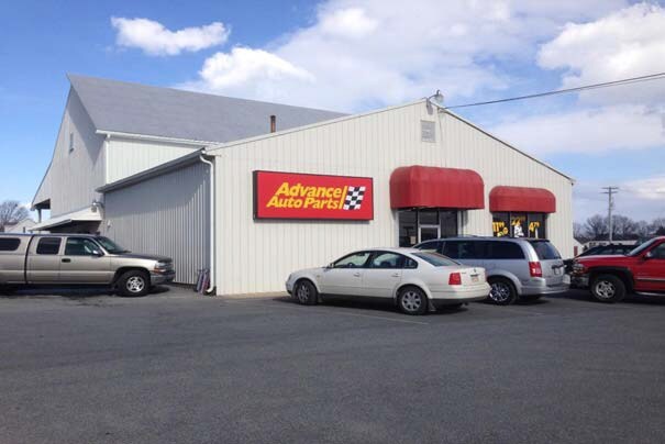
1775 W Main St
Lancaster, PA
Abram L Brubaker
070-43327-0-0000
1775 W MAIN ST
Lightindustrial
Lancaster
X
Pennsylvania
42071C0180F
13
2024
1.70 AC
2025
Lancaster County
010202
Philadelphia
17,660 SF
DEMOGRAPHICS near 1775 W Main St
1 Mile
3 Mile
5 Mile
2024 Total Population
3,628
24,159
56,487
2029 Population
3,660
24,372
56,821
Pop Growth 2024-2029
+ 0.88%
+ 0.88%
+ 0.59%
Average Age
43
41
40
2024 Total Households
1,418
9,591
21,525
HH Growth 2024-2029
+ 0.92%
+ 0.94%
+ 0.65%
Median Household Inc
$78,146
$66,402
$71,168
Avg Household Size
2.50
2.50
2.60
2024 Avg HH Vehicles
2.00
2.00
2.00
Median Home Value
$271,662
$232,208
$236,067
Median Year Built
1988
1981
1979
Nearby Places
Map Layers
Map Styles
 Street
 Aerial
- Restaurants
- Banks
- Shops
- Fitness
- Groceries
PUBLIC TRANSPORTATION
AIRPORT
Harrisburg International
DRIVE
WALK
Distance
Harrisburg International
51 min
38.0 mi
Freight Ports
Port of Wilmington, RI
DRIVE
WALK
Distance
Port of Wilmington, RI
95 min
64.1 mi
Nearby Properties
Address
Land Use
TOTAL SIZE
Lot Size
Zoning
Address
Land Use
TOTAL SIZE
Lot Size
Zoning
251,634 SF
16.28 AC
Address
Land Use
TOTAL SIZE
Lot Size
Zoning
226,686 SF
28 AC
RLD
Address
Land Use
TOTAL SIZE
Lot Size
Zoning
229,049 SF
26.80 AC
RLD
Address
Land Use
TOTAL SIZE
Lot Size
Zoning
203,091 SF
37.05 AC
Address
Land Use
TOTAL SIZE
Lot Size
Zoning
166,771 SF
10.76 AC
Address
Land Use
TOTAL SIZE
Lot Size
Zoning
155,373 SF
4.50 AC
Address
Land Use
TOTAL SIZE
Lot Size
Zoning
102,392 SF
21.77 AC
Address
Land Use
TOTAL SIZE
Lot Size
Zoning
90,600 SF
6.98 AC
Address
Land Use
TOTAL SIZE
Lot Size
Zoning
135,900 SF
11.79 AC
Address
Land Use
TOTAL SIZE
Lot Size
Zoning
1,350 SF
28.77 AC
Address
Land Use
TOTAL SIZE
Lot Size
Zoning
69,993 SF
Address
Land Use
TOTAL SIZE
Lot Size
Zoning
152,537 SF
17.20 AC
HC
Address
Land Use
TOTAL SIZE
Lot Size
Zoning
72,478 SF
11.83 AC
Address
Land Use
TOTAL SIZE
Lot Size
Zoning
57,966 SF
6.03 AC
Address
Land Use
TOTAL SIZE
Lot Size
Zoning
145,069 SF
16.30 AC
LI
Address
Land Use
TOTAL SIZE
Lot Size
Zoning
75,760 SF
4.85 AC
RMD
Address
Land Use
TOTAL SIZE
Lot Size
Zoning
92,217 SF
11.50 AC
C
Address
Land Use
TOTAL SIZE
Lot Size
Zoning
86,842 SF
12 AC
R2
Address
Land Use
TOTAL SIZE
Lot Size
Zoning
59,996 SF
6 AC
Address
Land Use
TOTAL SIZE
Lot Size
Zoning
44,302 SF
9.58 AC
RLD
Address
Land Use
TOTAL SIZE
Lot Size
Zoning
55,334 SF
5.70 AC
Address
Land Use
TOTAL SIZE
Lot Size
Zoning
81,780 SF
10.24 AC
Address
Land Use
TOTAL SIZE
Lot Size
Zoning
96,337 SF
34.60 AC
I
Address
Land Use
TOTAL SIZE
Lot Size
Zoning
50,888 SF
5.70 AC
RLD
Address
Land Use
TOTAL SIZE
Lot Size
Zoning
64,500 SF
19.60 AC
RLD
Address
Land Use
TOTAL SIZE
Lot Size
Zoning
79,968 SF
7.41 AC
Address
Land Use
TOTAL SIZE
Lot Size
Zoning
118,332 SF
8.80 AC
RLD
Address
Land Use
TOTAL SIZE
Lot Size
Zoning
16,054 SF
4.50 AC
HC
Address
Land Use
TOTAL SIZE
Lot Size
Zoning
41,648 SF
5.82 AC
Address
Land Use
TOTAL SIZE
Lot Size
Zoning
54,298 SF
5 AC
HC
The World's #1 Commercial Real Estate Marketplace
Connect with us
© 2025 CoStar Group
The information above has been obtained from sources believed reliable. While we do not doubt its accuracy we have not verified it and make no guarantee, warranty or representation about it. It is your responsibility to independently confirm its accuracy and completeness. Any projections, opinions, assumptions, or estimates used are for example only and do not represent the current or future performance of the property. The value of this transaction to you depends on tax and other factors which should be evaluated by your tax, financial, and legal advisors. You and your advisors should conduct a careful, independent investigation of the property to determine to your satisfaction the suitability of the property for your needs.