Property Record
17750 Katy Fwy, Houston, TX 77094
NEARBY LISTINGS FOR SALE OR LEASE
Property Detail
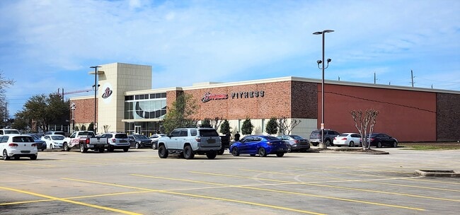
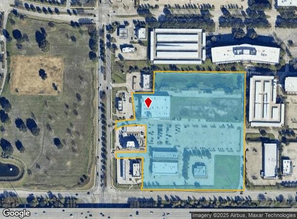
17750 Katy Fwy
1502050010001
Park Ten Commons At Barker Cypress Par R
Outdoorrecreationbeachmountaindesert
RES A BLK 1 PARK TEN COMMONS AT BARKER CYPRESS PAR R/P AMEND
X
Harris
48201C0620M
Texas
2024
13.74 AC
2025
Far Katy North
541702
Houston
59,555 SF
Houston-The Woodlands-Sugar Land, TX
DEMOGRAPHICS near 17750 Katy Fwy
1 Mile
3 Mile
5 Mile
2024 Total Population
9,750
71,587
257,275
2029 Population
10,053
72,856
262,696
Pop Growth 2024-2029
+ 3.11%
+ 1.77%
+ 2.11%
Average Age
34
37
36
2024 Total Households
4,076
25,240
89,716
HH Growth 2024-2029
+ 2.87%
+ 1.87%
+ 2.06%
Median Household Inc
$81,785
$79,008
$76,612
Avg Household Size
2.40
2.80
2.80
2024 Avg HH Vehicles
2.00
2.00
2.00
Median Home Value
$367,283
$252,827
$240,860
Median Year Built
2000
1995
1997
Nearby Places
- Restaurants
- Banks
- Shops
- Fitness
- Groceries
PUBLIC TRANSPORTATION
AIRPORT
William P Hobby
DRIVE
WALK
Distance
William P Hobby
49 min
33.4 mi
George Bush Intcntl/Houston
DRIVE
WALK
Distance
George Bush Intcntl/Houston
44 min
34.7 mi
Freight Ports
Port of Houston
DRIVE
WALK
Distance
Port of Houston
43 min
30.2 mi
Nearby Properties
Address
Land Use
TOTAL SIZE
Lot Size
Zoning
Address
Land Use
TOTAL SIZE
Lot Size
Zoning
695,923 SF
6.63 AC
Address
Land Use
TOTAL SIZE
Lot Size
Zoning
681,561 SF
7.98 AC
Address
Land Use
TOTAL SIZE
Lot Size
Zoning
451,973 SF
19.47 AC
Address
Land Use
TOTAL SIZE
Lot Size
Zoning
439,347 SF
13.50 AC
Address
Land Use
TOTAL SIZE
Lot Size
Zoning
417,092 SF
17.58 AC
Address
Land Use
TOTAL SIZE
Lot Size
Zoning
375,486 SF
12.36 AC
Address
Land Use
TOTAL SIZE
Lot Size
Zoning
341,844 SF
16.71 AC
Address
Land Use
TOTAL SIZE
Lot Size
Zoning
343,605 SF
11.90 AC
Address
Land Use
TOTAL SIZE
Lot Size
Zoning
319,717 SF
10.45 AC
Address
Land Use
TOTAL SIZE
Lot Size
Zoning
538,027 SF
30.06 AC
Address
Land Use
TOTAL SIZE
Lot Size
Zoning
534,796 SF
Address
Land Use
TOTAL SIZE
Lot Size
Zoning
266,532 SF
6.45 AC
Address
Land Use
TOTAL SIZE
Lot Size
Zoning
467,663 SF
7.30 AC
Address
Land Use
TOTAL SIZE
Lot Size
Zoning
284,321 SF
10.54 AC
Address
Land Use
TOTAL SIZE
Lot Size
Zoning
458,613 SF
19.50 AC
Address
Land Use
TOTAL SIZE
Lot Size
Zoning
214,347 SF
30.70 AC
Address
Land Use
TOTAL SIZE
Lot Size
Zoning
334,724 SF
21.23 AC
Address
Land Use
TOTAL SIZE
Lot Size
Zoning
489,188 SF
5.99 AC
Address
Land Use
TOTAL SIZE
Lot Size
Zoning
294,642 SF
14.47 AC
Address
Land Use
TOTAL SIZE
Lot Size
Zoning
370,329 SF
5 AC
Address
Land Use
TOTAL SIZE
Lot Size
Zoning
363,880 SF
17.32 AC
Address
Land Use
TOTAL SIZE
Lot Size
Zoning
367,873 SF
15.75 AC
Address
Land Use
TOTAL SIZE
Lot Size
Zoning
305,624 SF
Address
Land Use
TOTAL SIZE
Lot Size
Zoning
323,753 SF
14.02 AC
Address
Land Use
TOTAL SIZE
Lot Size
Zoning
486,927 SF
5.88 AC
Address
Land Use
TOTAL SIZE
Lot Size
Zoning
170,903 SF
15.53 AC
Address
Land Use
TOTAL SIZE
Lot Size
Zoning
334,971 SF
18.43 AC
Address
Land Use
TOTAL SIZE
Lot Size
Zoning
335,483 SF
13.83 AC
Address
Land Use
TOTAL SIZE
Lot Size
Zoning
349,634 SF
16.31 AC
Address
Land Use
TOTAL SIZE
Lot Size
Zoning
331,923 SF
13.27 AC
The World's #1 Commercial Real Estate Marketplace
Connect with us
© 2025 CoStar Group
The information above has been obtained from sources believed reliable. While we do not doubt its accuracy we have not verified it and make no guarantee, warranty or representation about it. It is your responsibility to independently confirm its accuracy and completeness. Any projections, opinions, assumptions, or estimates used are for example only and do not represent the current or future performance of the property. The value of this transaction to you depends on tax and other factors which should be evaluated by your tax, financial, and legal advisors. You and your advisors should conduct a careful, independent investigation of the property to determine to your satisfaction the suitability of the property for your needs.