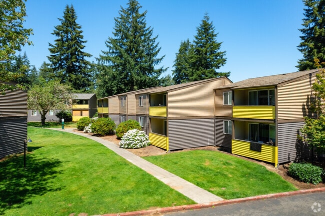
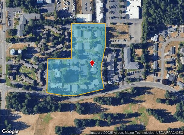
Property Record
1776 Village Way Se, Port Orchard, WA 98366
NEARBY LISTINGS FOR SALE OR LEASE
Property Detail
1776 Village Way Se
Bremerton-Silverdale, WA
Orchard Heights
4609-000-004-03-00
PARCEL I: THAT PART OF TRACT 4 OF THE PLAT OF ORCHARD HEIGHTS, AS PER PLAT RECORDED IN VOLUME 8 OF PLATS, PAGES 68, 69 AND 70, RECORDS OF KITSAP COUNTY, WASHINGTON, DESCRIBED AS FOLLOWS: BEGINNING AT THE SECTION CENTER CORNER COMMON TO SECTIONS 29, 3
Multifamilydwelling
Kitsap
X
Washington
53035C0390F
4
2025
5.49 AC
2026
South Kitsap County
092400
Bremerton/Silverdale
49,604 SF
DEMOGRAPHICS near 1776 Village Way Se
1 Mile
3 Mile
5 Mile
2024 Total Population
8,048
43,795
102,196
2029 Population
8,068
44,079
103,516
Pop Growth 2024-2029
+ 0.25%
+ 0.65%
+ 1.29%
Average Age
39
39
40
2024 Total Households
3,150
15,817
39,128
HH Growth 2024-2029
+ 0.16%
+ 0.71%
+ 1.43%
Median Household Inc
$80,880
$75,016
$71,868
Avg Household Size
2.50
2.40
2.40
2024 Avg HH Vehicles
2.00
2.00
2.00
Median Home Value
$414,553
$407,821
$415,056
Median Year Built
1979
1982
1979
Nearby Places
Map Layers
Map Styles
 Street
 Aerial
- Restaurants
- Banks
- Shops
- Fitness
- Groceries
PUBLIC TRANSPORTATION
AIRPORT
Seattle-Tacoma International
DRIVE
WALK
Distance
Seattle-Tacoma International
73 min
49.6 mi
Freight Ports
Port of Seattle
DRIVE
WALK
Distance
Port of Seattle
82 min
59.8 mi
SALE & LEASE HISTORY
LISTING DATE
SALE/LEASE

Jul 17, 2019
For Sale
Nearby Properties
Address
Land Use
TOTAL SIZE
Lot Size
Zoning
Address
Land Use
TOTAL SIZE
Lot Size
Zoning
143,022 SF
11.24 AC
R4
Address
Land Use
TOTAL SIZE
Lot Size
Zoning
127,853 SF
7.41 AC
R4
Address
Land Use
TOTAL SIZE
Lot Size
Zoning
135,371 SF
6.04 AC
R4
Address
Land Use
TOTAL SIZE
Lot Size
Zoning
17,592 SF
11.61 AC
UM
Address
Land Use
TOTAL SIZE
Lot Size
Zoning
25,973 SF
8.20 AC
CC
Address
Land Use
TOTAL SIZE
Lot Size
Zoning
110,994 SF
5.35 AC
R4
Address
Land Use
TOTAL SIZE
Lot Size
Zoning
1,092 SF
5.70 AC
CC
Address
Land Use
TOTAL SIZE
Lot Size
Zoning
125,582 SF
4.02 AC
NC
Address
Land Use
TOTAL SIZE
Lot Size
Zoning
0.54 AC
CITY
Address
Land Use
TOTAL SIZE
Lot Size
Zoning
110,778 SF
9.24 AC
CC
Address
Land Use
TOTAL SIZE
Lot Size
Zoning
79,615 SF
1.25 AC
DSAP
Address
Land Use
TOTAL SIZE
Lot Size
Zoning
158,870 SF
14.62 AC
CC
Address
Land Use
TOTAL SIZE
Lot Size
Zoning
185,893 SF
17.89 AC
CC
Address
Land Use
TOTAL SIZE
Lot Size
Zoning
77,580 SF
8.62 AC
UM
Address
Land Use
TOTAL SIZE
Lot Size
Zoning
14,660 SF
6.14 AC
UM
Address
Land Use
TOTAL SIZE
Lot Size
Zoning
14,660 SF
6.07 AC
UM
Address
Land Use
TOTAL SIZE
Lot Size
Zoning
62,642 SF
4.91 AC
UM
Address
Land Use
TOTAL SIZE
Lot Size
Zoning
56,006 SF
4.72 AC
UM
Address
Land Use
TOTAL SIZE
Lot Size
Zoning
45,379 SF
6.74 AC
UM
Address
Land Use
TOTAL SIZE
Lot Size
Zoning
69,192 SF
3.36 AC
UM
Address
Land Use
TOTAL SIZE
Lot Size
Zoning
2.33 AC
CITY
Address
Land Use
TOTAL SIZE
Lot Size
Zoning
60,977 SF
0.47 AC
DSAP
Address
Land Use
TOTAL SIZE
Lot Size
Zoning
68,708 SF
7.89 AC
PF
Address
Land Use
TOTAL SIZE
Lot Size
Zoning
24,930 SF
0.33 AC
DSAP
Address
Land Use
TOTAL SIZE
Lot Size
Zoning
39,800 SF
4.69 AC
CC
Address
Land Use
TOTAL SIZE
Lot Size
Zoning
45,904 SF
0.87 AC
NB
Address
Land Use
TOTAL SIZE
Lot Size
Zoning
67,000 SF
4.19 AC
C
Address
Land Use
TOTAL SIZE
Lot Size
Zoning
43,318 SF
2.54 AC
R4
Address
Land Use
TOTAL SIZE
Lot Size
Zoning
85,187 SF
4.30 AC
CC
The World's #1 Commercial Real Estate Marketplace
Connect with us
© 2025 CoStar Group
The information above has been obtained from sources believed reliable. While we do not doubt its accuracy we have not verified it and make no guarantee, warranty or representation about it. It is your responsibility to independently confirm its accuracy and completeness. Any projections, opinions, assumptions, or estimates used are for example only and do not represent the current or future performance of the property. The value of this transaction to you depends on tax and other factors which should be evaluated by your tax, financial, and legal advisors. You and your advisors should conduct a careful, independent investigation of the property to determine to your satisfaction the suitability of the property for your needs.