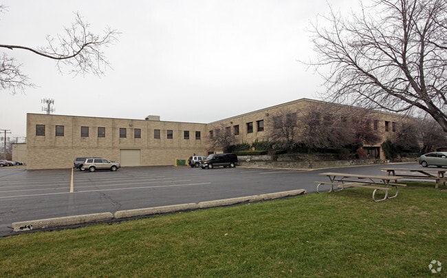
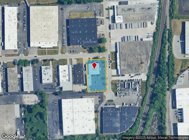
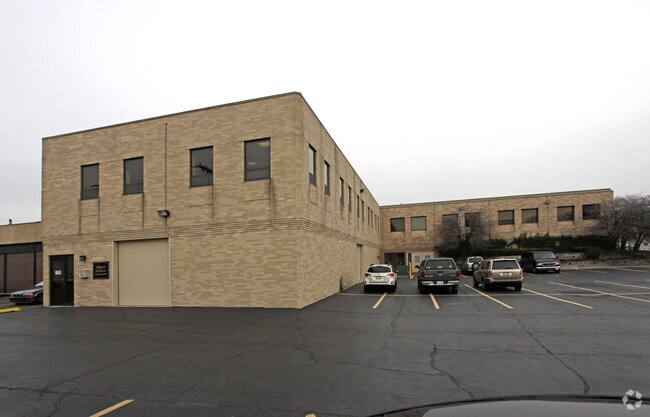
Property Record
1776 Winthrop Dr, Des Plaines, IL 60018
NEARBY LISTINGS FOR SALE OR LEASE
Property Detail
1776 Winthrop Dr
Chicago-Naperville-Elgin, IL-IN-WI
Anderson - Miller Desplaines
09-30-100-057-0000
(ANDERSON)-(MILLER) (DESPLAINES) INDUSTRIAL PARK (UNI T3) RESUB OF LTS3-4 & PT LTS2,5-6 IN GREWES SUB OF PT NW & WH WH NE LYI
Industrialgeneral
Cook
X
Illinois
17031C0218J
2-4
2023
1.24 AC
2024
O'Hare
770602
Chicago
26,795 SF
DEMOGRAPHICS near 1776 Winthrop Dr
1 Mile
3 Mile
5 Mile
2024 Total Population
7,356
91,984
269,862
2029 Population
7,215
89,183
262,181
Pop Growth 2024-2029
(1.92%)
(3.05%)
(2.85%)
Average Age
44
41
42
2024 Total Households
2,515
35,328
102,778
HH Growth 2024-2029
(2.11%)
(3.30%)
(3.15%)
Median Household Inc
$79,576
$74,780
$81,547
Avg Household Size
2.80
2.50
2.50
2024 Avg HH Vehicles
2.00
2.00
2.00
Median Home Value
$289,363
$296,210
$326,246
Median Year Built
1966
1968
1968
Nearby Places
Map Layers
Map Styles
 Street
 Aerial
- Restaurants
- Banks
- Shops
- Fitness
- Groceries
PUBLIC TRANSPORTATION
COMMUTER RAIL
Des Plaines Station (Union Pacific Northwest Line - Northeast Illinois Regional Commuter Railroad (Metra))
DRIVE
WALK
Distance
Des Plaines Station (Union Pacific Northwest Line - Northeast Illinois Regional Commuter Railroad (Metra))
6 min
2.7 mi
Cumberland Station (Union Pacific Northwest Line - Northeast Illinois Regional Commuter Railroad (Metra))
DRIVE
WALK
Distance
Cumberland Station (Union Pacific Northwest Line - Northeast Illinois Regional Commuter Railroad (Metra))
7 min
3.0 mi
AIRPORT
Chicago O'Hare International
DRIVE
WALK
Distance
Chicago O'Hare International
12 min
6.2 mi
Chicago Midway International
DRIVE
WALK
Distance
Chicago Midway International
42 min
23.6 mi
Freight Ports
Port Milwaukee
DRIVE
WALK
Distance
Port Milwaukee
91 min
74.9 mi
Nearby Properties
Address
Land Use
TOTAL SIZE
Lot Size
Zoning
Address
Land Use
TOTAL SIZE
Lot Size
Zoning
108,216 SF
7.87 AC
Address
Land Use
TOTAL SIZE
Lot Size
Zoning
Address
Land Use
TOTAL SIZE
Lot Size
Zoning
310,751 SF
15.04 AC
Address
Land Use
TOTAL SIZE
Lot Size
Zoning
179,780 SF
8.12 AC
I
Address
Land Use
TOTAL SIZE
Lot Size
Zoning
58,373 SF
11.22 AC
Address
Land Use
TOTAL SIZE
Lot Size
Zoning
Address
Land Use
TOTAL SIZE
Lot Size
Zoning
410,822 SF
14.26 AC
Address
Land Use
TOTAL SIZE
Lot Size
Zoning
208,000 SF
10.35 AC
Address
Land Use
TOTAL SIZE
Lot Size
Zoning
132,699 SF
6.74 AC
Address
Land Use
TOTAL SIZE
Lot Size
Zoning
413,338 SF
23.92 AC
Address
Land Use
TOTAL SIZE
Lot Size
Zoning
688,900 SF
20.91 AC
Address
Land Use
TOTAL SIZE
Lot Size
Zoning
Address
Land Use
TOTAL SIZE
Lot Size
Zoning
533,629 SF
24.19 AC
Address
Land Use
TOTAL SIZE
Lot Size
Zoning
508,246 SF
32.81 AC
Address
Land Use
TOTAL SIZE
Lot Size
Zoning
1.23 AC
Address
Land Use
TOTAL SIZE
Lot Size
Zoning
160,000 SF
2.14 AC
Address
Land Use
TOTAL SIZE
Lot Size
Zoning
378,525 SF
0.11 AC
Address
Land Use
TOTAL SIZE
Lot Size
Zoning
206,400 SF
9.73 AC
I
Address
Land Use
TOTAL SIZE
Lot Size
Zoning
667,821 SF
20.55 AC
Address
Land Use
TOTAL SIZE
Lot Size
Zoning
53,760 SF
5.36 AC
Address
Land Use
TOTAL SIZE
Lot Size
Zoning
214,652 SF
7.62 AC
I
Address
Land Use
TOTAL SIZE
Lot Size
Zoning
279,103 SF
7.09 AC
Address
Land Use
TOTAL SIZE
Lot Size
Zoning
6.28 AC
Address
Land Use
TOTAL SIZE
Lot Size
Zoning
134,590 SF
9.92 AC
I
Address
Land Use
TOTAL SIZE
Lot Size
Zoning
282,366 SF
2.48 AC
Address
Land Use
TOTAL SIZE
Lot Size
Zoning
132,574 SF
5.91 AC
Address
Land Use
TOTAL SIZE
Lot Size
Zoning
489,538 SF
5.94 AC
Address
Land Use
TOTAL SIZE
Lot Size
Zoning
Address
Land Use
TOTAL SIZE
Lot Size
Zoning
134,170 SF
2.15 AC
Address
Land Use
TOTAL SIZE
Lot Size
Zoning
214,200 SF
16.97 AC
The World's #1 Commercial Real Estate Marketplace
Connect with us
© 2025 CoStar Group
The information above has been obtained from sources believed reliable. While we do not doubt its accuracy we have not verified it and make no guarantee, warranty or representation about it. It is your responsibility to independently confirm its accuracy and completeness. Any projections, opinions, assumptions, or estimates used are for example only and do not represent the current or future performance of the property. The value of this transaction to you depends on tax and other factors which should be evaluated by your tax, financial, and legal advisors. You and your advisors should conduct a careful, independent investigation of the property to determine to your satisfaction the suitability of the property for your needs.