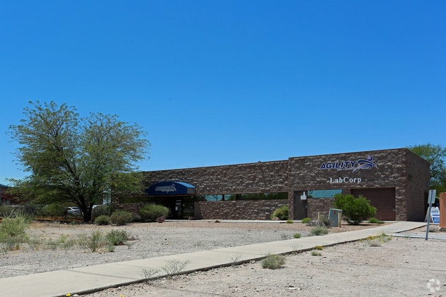
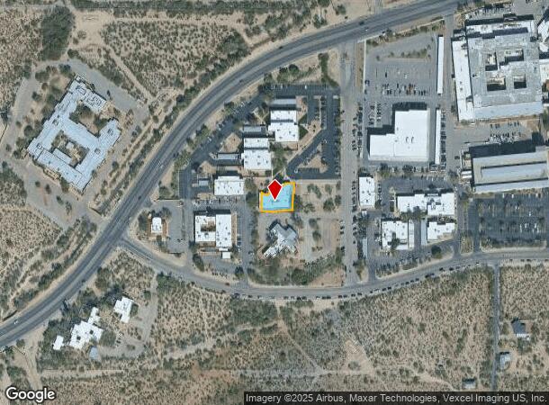
Property Record
1777 W Saint Marys Rd, Tucson, AZ 85745
NEARBY LISTINGS FOR SALE OR LEASE
Property Detail
1777 W Saint Marys Rd
Tucson, AZ
St Marys Medical Park
116-15-5120
ST MARYS MEDICAL PARK LOT 0004 (M&P 45/9)
Medicalbuilding
Pima
X
Arizona
04019C2260L
4
2025
0.20 AC
2025
Downtown Tucson
004415
Tucson
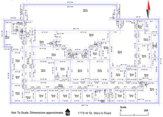
7,668 SF
DEMOGRAPHICS near 1777 W Saint Marys Rd
1 Mile
3 Mile
5 Mile
2024 Total Population
7,568
83,201
205,770
2029 Population
7,796
86,562
213,308
Pop Growth 2024-2029
+ 3.01%
+ 4.04%
+ 3.66%
Average Age
39
36
37
2024 Total Households
3,397
36,031
87,434
HH Growth 2024-2029
+ 3.00%
+ 4.23%
+ 3.72%
Median Household Inc
$41,088
$41,105
$42,158
Avg Household Size
2.20
2.10
2.20
2024 Avg HH Vehicles
1.00
1.00
2.00
Median Home Value
$204,012
$220,525
$203,489
Median Year Built
1974
1979
1976
Nearby Places
Map Layers
Map Styles
 Street
 Aerial
- Restaurants
- Banks
- Shops
- Fitness
- Groceries
PUBLIC TRANSPORTATION
COMMUTER RAIL
DRIVE
WALK
Distance
7 min
2.5 mi
AIRPORT
Tucson International
DRIVE
WALK
Distance
Tucson International
20 min
10.2 mi
SALE & LEASE HISTORY
LISTING DATE
SALE/LEASE

Mar 25, 2022
For Lease
Feb 06, 2025
For Sale
Nearby Properties
Address
Land Use
TOTAL SIZE
Lot Size
Zoning
Address
Land Use
TOTAL SIZE
Lot Size
Zoning
251,851 SF
0.74 AC
Address
Land Use
TOTAL SIZE
Lot Size
Zoning
134,710 SF
9.59 AC
I1
Address
Land Use
TOTAL SIZE
Lot Size
Zoning
839,498 SF
16.41 AC
R2
Address
Land Use
TOTAL SIZE
Lot Size
Zoning
813,186 SF
3.65 AC
OCR2
Address
Land Use
TOTAL SIZE
Lot Size
Zoning
819,879 SF
44.77 AC
SP
Address
Land Use
TOTAL SIZE
Lot Size
Zoning
657,188 SF
24.97 AC
PAD5
Address
Land Use
TOTAL SIZE
Lot Size
Zoning
655,604 SF
233.08 AC
RX2
Address
Land Use
TOTAL SIZE
Lot Size
Zoning
89,497 SF
0.51 AC
Address
Land Use
TOTAL SIZE
Lot Size
Zoning
868,743 SF
17.17 AC
O3
Address
Land Use
TOTAL SIZE
Lot Size
Zoning
326,845 SF
0.71 AC
Address
Land Use
TOTAL SIZE
Lot Size
Zoning
380,470 SF
17.48 AC
R1
Address
Land Use
TOTAL SIZE
Lot Size
Zoning
60,426 SF
0.43 AC
OCR2
Address
Land Use
TOTAL SIZE
Lot Size
Zoning
239,060 SF
7.85 AC
Address
Land Use
TOTAL SIZE
Lot Size
Zoning
495,871 SF
3.56 AC
Address
Land Use
TOTAL SIZE
Lot Size
Zoning
60,377 SF
6.25 AC
I1
Address
Land Use
TOTAL SIZE
Lot Size
Zoning
299,658 SF
0.77 AC
Address
Land Use
TOTAL SIZE
Lot Size
Zoning
300,034 SF
2.45 AC
C3
Address
Land Use
TOTAL SIZE
Lot Size
Zoning
293,092 SF
0.71 AC
Address
Land Use
TOTAL SIZE
Lot Size
Zoning
213,400 SF
0.46 AC
Address
Land Use
TOTAL SIZE
Lot Size
Zoning
468,481 SF
2.56 AC
Address
Land Use
TOTAL SIZE
Lot Size
Zoning
157,054 SF
0.84 AC
Address
Land Use
TOTAL SIZE
Lot Size
Zoning
418,519 SF
2.36 AC
OCR2
Address
Land Use
TOTAL SIZE
Lot Size
Zoning
198,830 SF
2.22 AC
Address
Land Use
TOTAL SIZE
Lot Size
Zoning
227,880 SF
0.21 AC
OCR2
Address
Land Use
TOTAL SIZE
Lot Size
Zoning
121,488 SF
0.17 AC
R2
Address
Land Use
TOTAL SIZE
Lot Size
Zoning
192,730 SF
0.91 AC
OCR2
Address
Land Use
TOTAL SIZE
Lot Size
Zoning
190,012 SF
1.62 AC
C3
Address
Land Use
TOTAL SIZE
Lot Size
Zoning
298,003 SF
0.73 AC
Address
Land Use
TOTAL SIZE
Lot Size
Zoning
241,942 SF
0.58 AC
Address
Land Use
TOTAL SIZE
Lot Size
Zoning
151,822 SF
1.73 AC
R2
The World's #1 Commercial Real Estate Marketplace
Connect with us
© 2025 CoStar Group
The information above has been obtained from sources believed reliable. While we do not doubt its accuracy we have not verified it and make no guarantee, warranty or representation about it. It is your responsibility to independently confirm its accuracy and completeness. Any projections, opinions, assumptions, or estimates used are for example only and do not represent the current or future performance of the property. The value of this transaction to you depends on tax and other factors which should be evaluated by your tax, financial, and legal advisors. You and your advisors should conduct a careful, independent investigation of the property to determine to your satisfaction the suitability of the property for your needs.