Property Record
17795 State Highway 155, Flint, TX 75762
Property Detail
17795 State Highway 155
Tyler, TX
ABST A0018 T QUEVADOTRACT 14A SEC 27
1-00000-0018-27-014010
Smith
Agriculturalland
Texas
B and X Area of moderate flood hazard, usually the area between the limits of the 100-year and 500-year floods.
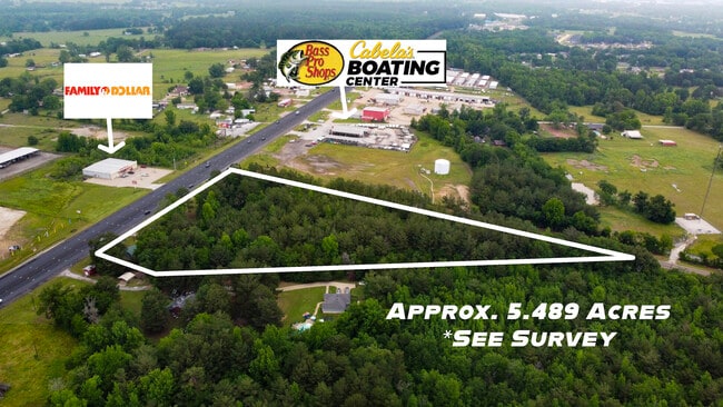
5.17 AC
2025
Noonday
2025
Other Market Areas
001915
NEARBY LISTINGS FOR SALE OR LEASE
DEMOGRAPHICS near 17795 State Highway 155
1 mile
3 mile
5 mile
2025 Total Population
778
4,624
23,486
2030 Population
842
4,962
25,080
Pop Growth 2025-2030
+ 8.23%
+ 7.31%
+ 6.79%
Average Age
42
42
42
2025 Total Households
277
1,743
9,002
HH Growth 2025-2030
+ 7.94%
+ 6.71%
+ 6.40%
Median Household Inc
$90,234
$92,406
$88,699
Avg Household Size
2.60
2.50
2.50
2025 Avg HH Vehicles
2.00
2.00
2.00
Median Home Value
$332,727
$347,932
$348,249
Median Year Built
2001
2001
1999
Nearby Places
Map Layers
Map Styles
 Street
 Aerial
Layers
 Traffic
 Biking
Places
Listings with unknown addresses are not visible on the map
- Restaurants
- Banks
- Shops
- Fitness
- Groceries
PUBLIC TRANSPORTATION
AIRPORT
Tyler Pounds Regional
Drive
Walk
Distance
Tyler Pounds Regional
20 min
13.2 mi
Freight Ports
Port of Shreveport
Drive
Walk
Distance
Port of Shreveport
135 min
119.6 mi
SALE & LEASE HISTORY
LISTING DATE
SALE/LEASE

May 19, 2023
For Sale
Nearby Properties
Address
Land Use
TOTAL SIZE
Lot Size
Zoning
Address
Land Use
TOTAL SIZE
Lot Size
Zoning
21.31 AC
Address
Land Use
TOTAL SIZE
Lot Size
Zoning
112.13 AC
Address
Land Use
TOTAL SIZE
Lot Size
Zoning
27,131 SF
2.93 AC
Address
Land Use
TOTAL SIZE
Lot Size
Zoning
25,356 SF
2.58 AC
Address
Land Use
TOTAL SIZE
Lot Size
Zoning
97.48 AC
Address
Land Use
TOTAL SIZE
Lot Size
Zoning
47,744 SF
7.71 AC
Address
Land Use
TOTAL SIZE
Lot Size
Zoning
5,000 SF
12.64 AC
Address
Land Use
TOTAL SIZE
Lot Size
Zoning
9,050 SF
6 AC
Address
Land Use
TOTAL SIZE
Lot Size
Zoning
36,000 SF
4.33 AC
Address
Land Use
TOTAL SIZE
Lot Size
Zoning
29,550 SF
4.70 AC
Address
Land Use
TOTAL SIZE
Lot Size
Zoning
37.35 AC
Address
Land Use
TOTAL SIZE
Lot Size
Zoning
66,528 SF
2.61 AC
Address
Land Use
TOTAL SIZE
Lot Size
Zoning
3,056 SF
4.36 AC
Address
Land Use
TOTAL SIZE
Lot Size
Zoning
4.95 AC
Address
Land Use
TOTAL SIZE
Lot Size
Zoning
5,000 SF
4.89 AC
Address
Land Use
TOTAL SIZE
Lot Size
Zoning
12,000 SF
2.95 AC
Address
Land Use
TOTAL SIZE
Lot Size
Zoning
868 SF
130.55 AC
Address
Land Use
TOTAL SIZE
Lot Size
Zoning
1,800 SF
9.83 AC
Address
Land Use
TOTAL SIZE
Lot Size
Zoning
3,600 SF
2.01 AC
Address
Land Use
TOTAL SIZE
Lot Size
Zoning
Address
Land Use
TOTAL SIZE
Lot Size
Zoning
30,228 SF
2.74 AC
Address
Land Use
TOTAL SIZE
Lot Size
Zoning
4,640 SF
2.58 AC
Address
Land Use
TOTAL SIZE
Lot Size
Zoning
Address
Land Use
TOTAL SIZE
Lot Size
Zoning
9,100 SF
1.28 AC
Address
Land Use
TOTAL SIZE
Lot Size
Zoning
5,656 SF
1.50 AC
Address
Land Use
TOTAL SIZE
Lot Size
Zoning
Address
Land Use
TOTAL SIZE
Lot Size
Zoning
6,507 SF
10.29 AC
Address
Land Use
TOTAL SIZE
Lot Size
Zoning
28,128 SF
1.82 AC
Address
Land Use
TOTAL SIZE
Lot Size
Zoning
3,137 SF
3.18 AC
Address
Land Use
TOTAL SIZE
Lot Size
Zoning
360 SF
3.05 AC
The World's #1 Commercial Real Estate Marketplace
Connect with us
© 2026 CoStar Group
The information above has been obtained from sources believed reliable. While we do not doubt its accuracy we have not verified it and make no guarantee, warranty or representation about it. It is your responsibility to independently confirm its accuracy and completeness. Any projections, opinions, assumptions, or estimates used are for example only and do not represent the current or future performance of the property. The value of this transaction to you depends on tax and other factors which should be evaluated by your tax, financial, and legal advisors. You and your advisors should conduct a careful, independent investigation of the property to determine to your satisfaction the suitability of the property for your needs.