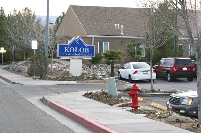
Property Record
178 S 1200 E, Saint George, UT 84790

Property Detail
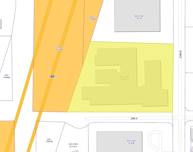
178 S 1200 E
0315401
SUBDIVISION: ST GEORGE CITY SUR PLAT E BLK 21 (SG) LOT: 8 BEG AT PT ON E R/W/L I-15 BEING N89*5116 W 218.83 FT FM NE COR LOT 8 BLK 21 PLAT E SGCS & S17*1630 W 300.47 FT TO POB TH S89*5116 E 348.36 FT TO W LN 1200 EAST ST; TH S0*0844 W 260.86 FT TO PT
Commercialnec
Washington
C-3
Utah
B and X Area of moderate flood hazard, usually the area between the limits of the 100-year and 500-year floods.
8
2024
2.48 AC
2025
Downtown Saint George
271200
Other Market Areas
69,190 SF
St. George, UT
NEARBY LISTINGS FOR SALE OR LEASE
-
-
View all Saint George listings for sale on LoopNet.com
DEMOGRAPHICS near 178 S 1200 E
1 mile
3 mile
5 mile
2025 Total Population
7,926
59,842
128,491
2030 Population
8,604
65,181
141,391
Pop Growth 2025-2030
+ 8.55%
+ 8.92%
+ 10.04%
Average Age
39
39
39
2025 Total Households
2,798
20,642
44,132
HH Growth 2025-2030
+ 8.65%
+ 9.26%
+ 10.40%
Median Household Inc
$56,661
$69,425
$78,292
Avg Household Size
2.40
2.70
2.80
2025 Avg HH Vehicles
2.00
2.00
2.00
Median Home Value
$414,878
$492,104
$536,606
Median Year Built
1994
1998
2002
Nearby Places
Map Layers
Map Styles
 Street
 Aerial
Transit
 Traffic
 Biking
Places
Listings with unknown addresses are not visible on the map
- Restaurants
- Banks
- Shops
- Fitness
- Groceries
PUBLIC TRANSPORTATION
AIRPORT
St George Regional
Drive
Walk
Distance
St George Regional
10 min
3.8 mi
Nearby Properties
Address
Land Use
TOTAL SIZE
Lot Size
Zoning
Address
Land Use
TOTAL SIZE
Lot Size
Zoning
1,120,988 SF
52.22 AC
PDCOM
Address
Land Use
TOTAL SIZE
Lot Size
Zoning
319,351 SF
31.39 AC
PD
Address
Land Use
TOTAL SIZE
Lot Size
Zoning
319,351 SF
31.39 AC
Address
Land Use
TOTAL SIZE
Lot Size
Zoning
163,605 SF
13.51 AC
C3
Address
Land Use
TOTAL SIZE
Lot Size
Zoning
252,737 SF
3.95 AC
C-4
Address
Land Use
TOTAL SIZE
Lot Size
Zoning
175,817 SF
30.20 AC
Address
Land Use
TOTAL SIZE
Lot Size
Zoning
118,603 SF
16.56 AC
Address
Land Use
TOTAL SIZE
Lot Size
Zoning
141,151 SF
15 AC
PDCOM
Address
Land Use
TOTAL SIZE
Lot Size
Zoning
206,801 SF
12.60 AC
PD
Address
Land Use
TOTAL SIZE
Lot Size
Zoning
230,880 SF
25.58 AC
C-2
Address
Land Use
TOTAL SIZE
Lot Size
Zoning
9,037 SF
188.69 AC
C2
Address
Land Use
TOTAL SIZE
Lot Size
Zoning
66,506 SF
15.12 AC
Address
Land Use
TOTAL SIZE
Lot Size
Zoning
97,572 SF
10.51 AC
PD
Address
Land Use
TOTAL SIZE
Lot Size
Zoning
141,567 SF
1.31 AC
C-4
Address
Land Use
TOTAL SIZE
Lot Size
Zoning
280,428 SF
1.96 AC
C-4
Address
Land Use
TOTAL SIZE
Lot Size
Zoning
91,517 SF
8.96 AC
C2
Address
Land Use
TOTAL SIZE
Lot Size
Zoning
68,899 SF
7.36 AC
C3
Address
Land Use
TOTAL SIZE
Lot Size
Zoning
84,384 SF
6.34 AC
C2
Address
Land Use
TOTAL SIZE
Lot Size
Zoning
88,445 SF
3.28 AC
C2
Address
Land Use
TOTAL SIZE
Lot Size
Zoning
153,140 SF
17.17 AC
C-3
Address
Land Use
TOTAL SIZE
Lot Size
Zoning
120,219 SF
11.88 AC
Address
Land Use
TOTAL SIZE
Lot Size
Zoning
97,202 SF
2.92 AC
C3
Address
Land Use
TOTAL SIZE
Lot Size
Zoning
67,974 SF
7.04 AC
Address
Land Use
TOTAL SIZE
Lot Size
Zoning
76,907 SF
4 AC
PDCOM
Address
Land Use
TOTAL SIZE
Lot Size
Zoning
72,862 SF
3.20 AC
Address
Land Use
TOTAL SIZE
Lot Size
Zoning
94,810 SF
3.15 AC
C-3
Address
Land Use
TOTAL SIZE
Lot Size
Zoning
59,500 SF
4.93 AC
R110
Address
Land Use
TOTAL SIZE
Lot Size
Zoning
57,312 SF
3.14 AC
PDCOM
Address
Land Use
TOTAL SIZE
Lot Size
Zoning
137,662 SF
7.81 AC
PD
Address
Land Use
TOTAL SIZE
Lot Size
Zoning
67,139 SF
1.25 AC
The World's #1 Commercial Real Estate Marketplace
Connect with us
© 2026 CoStar Group
The information above has been obtained from sources believed reliable. While we do not doubt its accuracy we have not verified it and make no guarantee, warranty or representation about it. It is your responsibility to independently confirm its accuracy and completeness. Any projections, opinions, assumptions, or estimates used are for example only and do not represent the current or future performance of the property. The value of this transaction to you depends on tax and other factors which should be evaluated by your tax, financial, and legal advisors. You and your advisors should conduct a careful, independent investigation of the property to determine to your satisfaction the suitability of the property for your needs.