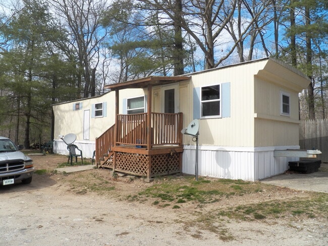
Property Record
178 Snake Meadow Rd, Danielson, CT 06239


NEARBY LISTINGS FOR SALE OR LEASE
-
-
View all Danielson listings for sale on LoopNet.com
Property Detail
178 Snake Meadow Rd
KILL-000233-000000-000016
Windham
Commercialnec
Connecticut
X
0.50 AC
09015C0265F
Windham County
2025
Hartford
2025
Willimantic, CT
904102
DEMOGRAPHICS near 178 Snake Meadow Rd
1 Mile
3 Mile
5 Mile
2024 Total Population
564
8,488
24,927
2029 Population
564
8,529
24,865
Pop Growth 2024-2029
0.00%
+ 0.48%
(0.25%)
Average Age
43
42
42
2024 Total Households
223
3,401
10,071
HH Growth 2024-2029
0.00%
+ 0.56%
(0.16%)
Median Household Inc
$83,717
$71,611
$76,577
Avg Household Size
2.50
2.40
2.40
2024 Avg HH Vehicles
2.00
2.00
2.00
Median Home Value
$225,610
$238,160
$244,489
Median Year Built
1979
1969
1970
Nearby Places
Map Layers
Map Styles
 Street
 Aerial
- Restaurants
- Banks
- Shops
- Fitness
- Groceries
PUBLIC TRANSPORTATION
AIRPORT
Rhode Island Tf Green International
DRIVE
WALK
Distance
Rhode Island Tf Green International
40 min
29.5 mi
Freight Ports
Port of Davisville, RI
DRIVE
WALK
Distance
Port of Davisville, RI
51 min
38.7 mi
SALE & LEASE HISTORY
LISTING DATE
SALE/LEASE

Dec 13, 2023
For Sale
Apr 12, 2021
For Sale
Nearby Properties
Address
Land Use
TOTAL SIZE
Lot Size
Zoning
Address
Land Use
TOTAL SIZE
Lot Size
Zoning
22 AC
I
Address
Land Use
TOTAL SIZE
Lot Size
Zoning
53,306 SF
1.60 AC
BI
Address
Land Use
TOTAL SIZE
Lot Size
Zoning
59,552 SF
4.28 AC
GC
Address
Land Use
TOTAL SIZE
Lot Size
Zoning
50,707 SF
10.50 AC
BRHD
Address
Land Use
TOTAL SIZE
Lot Size
Zoning
67,994 SF
8.30 AC
GC
Address
Land Use
TOTAL SIZE
Lot Size
Zoning
18,958 SF
1.52 AC
BGC
Address
Land Use
TOTAL SIZE
Lot Size
Zoning
9.12 AC
R10
Address
Land Use
TOTAL SIZE
Lot Size
Zoning
14,524 SF
0.92 AC
RHD
Address
Land Use
TOTAL SIZE
Lot Size
Zoning
6,250 SF
225 AC
RD
Address
Land Use
TOTAL SIZE
Lot Size
Zoning
4.60 AC
BRHD
Address
Land Use
TOTAL SIZE
Lot Size
Zoning
33,486 SF
4.10 AC
MMUDD
Address
Land Use
TOTAL SIZE
Lot Size
Zoning
28,678 SF
0.95 AC
BRHD
Address
Land Use
TOTAL SIZE
Lot Size
Zoning
4.80 AC
RHD
Address
Land Use
TOTAL SIZE
Lot Size
Zoning
Address
Land Use
TOTAL SIZE
Lot Size
Zoning
2.83 AC
GC
Address
Land Use
TOTAL SIZE
Lot Size
Zoning
7,116 SF
2.10 AC
BGC
Address
Land Use
TOTAL SIZE
Lot Size
Zoning
4.75 AC
PBO
Address
Land Use
TOTAL SIZE
Lot Size
Zoning
23,584 SF
1.60 AC
BGC
Address
Land Use
TOTAL SIZE
Lot Size
Zoning
Address
Land Use
TOTAL SIZE
Lot Size
Zoning
105 AC
RD
Address
Land Use
TOTAL SIZE
Lot Size
Zoning
23,075 SF
3.88 AC
GC
Address
Land Use
TOTAL SIZE
Lot Size
Zoning
15,840 SF
14.90 AC
RD
Address
Land Use
TOTAL SIZE
Lot Size
Zoning
34,900 SF
0.64 AC
CBD
Address
Land Use
TOTAL SIZE
Lot Size
Zoning
6,995 SF
0.82 AC
BGC
Address
Land Use
TOTAL SIZE
Lot Size
Zoning
12 AC
I
Address
Land Use
TOTAL SIZE
Lot Size
Zoning
5.32 AC
GC
Address
Land Use
TOTAL SIZE
Lot Size
Zoning
10.30 AC
RD
Address
Land Use
TOTAL SIZE
Lot Size
Zoning
2 AC
RD
Address
Land Use
TOTAL SIZE
Lot Size
Zoning
8,470 SF
0.69 AC
RHD
Address
Land Use
TOTAL SIZE
Lot Size
Zoning
5.53 AC
RA60
The World's #1 Commercial Real Estate Marketplace
Connect with us
© 2026 CoStar Group
The information above has been obtained from sources believed reliable. While we do not doubt its accuracy we have not verified it and make no guarantee, warranty or representation about it. It is your responsibility to independently confirm its accuracy and completeness. Any projections, opinions, assumptions, or estimates used are for example only and do not represent the current or future performance of the property. The value of this transaction to you depends on tax and other factors which should be evaluated by your tax, financial, and legal advisors. You and your advisors should conduct a careful, independent investigation of the property to determine to your satisfaction the suitability of the property for your needs.