Property Record
1780 Newport Rd, Manheim, PA 17545
NEARBY LISTINGS FOR SALE OR LEASE
-
-
View all Manheim listings for sale on LoopNet.com
Property Detail
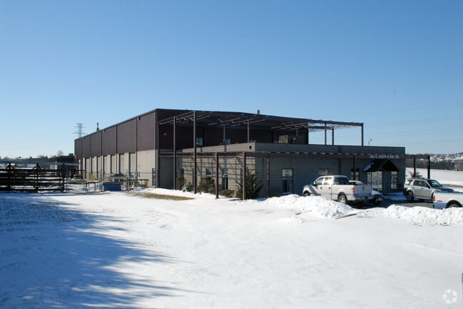
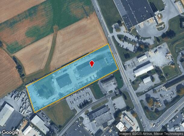
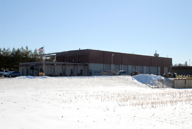
1780 Newport Rd
Lancaster, PA
Carvell & Rick Inc
210-31445-0-0000
1780 NEWPORT RD
Servicestation
Lancaster
X
Pennsylvania
42071C0188F
6
2024
6 AC
2025
Lancaster County
010301
Philadelphia
28,380 SF
DEMOGRAPHICS near 1780 Newport Rd
1 Mile
3 Mile
5 Mile
2024 Total Population
3,133
18,055
82,126
2029 Population
3,116
18,109
82,845
Pop Growth 2024-2029
(0.54%)
+ 0.30%
+ 0.88%
Average Age
40
41
43
2024 Total Households
1,097
6,801
31,358
HH Growth 2024-2029
(0.46%)
+ 0.37%
+ 0.96%
Median Household Inc
$101,538
$80,636
$76,401
Avg Household Size
2.80
2.60
2.50
2024 Avg HH Vehicles
2.00
2.00
2.00
Median Home Value
$259,201
$243,362
$258,200
Median Year Built
1982
1980
1980
Nearby Places
Map Layers
Map Styles
 Street
 Aerial
- Restaurants
- Banks
- Shops
- Fitness
- Groceries
PUBLIC TRANSPORTATION
COMMUTER RAIL
Lancaster (Keystone Service - Amtrak, Pennsylvanian - Amtrak)
DRIVE
WALK
Distance
Lancaster (Keystone Service - Amtrak, Pennsylvanian - Amtrak)
12 min
8.5 mi
AIRPORT
Harrisburg International
DRIVE
WALK
Distance
Harrisburg International
47 min
37.8 mi
Freight Ports
Port of Wilmington, RI
DRIVE
WALK
Distance
Port of Wilmington, RI
92 min
52.6 mi
Nearby Properties
Address
Land Use
TOTAL SIZE
Lot Size
Zoning
Address
Land Use
TOTAL SIZE
Lot Size
Zoning
740,990 SF
106.29 AC
Address
Land Use
TOTAL SIZE
Lot Size
Zoning
354,921 SF
6.36 AC
Address
Land Use
TOTAL SIZE
Lot Size
Zoning
103,448 SF
79.90 AC
A
Address
Land Use
TOTAL SIZE
Lot Size
Zoning
122,512 SF
22.36 AC
I
Address
Land Use
TOTAL SIZE
Lot Size
Zoning
123,018 SF
14.30 AC
HC
Address
Land Use
TOTAL SIZE
Lot Size
Zoning
73,648 SF
10.20 AC
R-1
Address
Land Use
TOTAL SIZE
Lot Size
Zoning
92,217 SF
11.50 AC
C
Address
Land Use
TOTAL SIZE
Lot Size
Zoning
51,954 SF
11.80 AC
R-1
Address
Land Use
TOTAL SIZE
Lot Size
Zoning
81,044 SF
4.67 AC
Address
Land Use
TOTAL SIZE
Lot Size
Zoning
104,828 SF
5.94 AC
I
Address
Land Use
TOTAL SIZE
Lot Size
Zoning
66,600 SF
24.43 AC
B-4
Address
Land Use
TOTAL SIZE
Lot Size
Zoning
220,374 SF
20.62 AC
I
Address
Land Use
TOTAL SIZE
Lot Size
Zoning
14.50 AC
I
Address
Land Use
TOTAL SIZE
Lot Size
Zoning
51,064 SF
1.28 AC
Address
Land Use
TOTAL SIZE
Lot Size
Zoning
17,176 SF
3.95 AC
CC
Address
Land Use
TOTAL SIZE
Lot Size
Zoning
34,394 SF
1.82 AC
Address
Land Use
TOTAL SIZE
Lot Size
Zoning
44,625 SF
9.61 AC
C-2
Address
Land Use
TOTAL SIZE
Lot Size
Zoning
46,339 SF
39 AC
RMD
Address
Land Use
TOTAL SIZE
Lot Size
Zoning
27,929 SF
8.30 AC
Address
Land Use
TOTAL SIZE
Lot Size
Zoning
29,249 SF
4 AC
R-1
Address
Land Use
TOTAL SIZE
Lot Size
Zoning
43,155 SF
2 AC
C-1
Address
Land Use
TOTAL SIZE
Lot Size
Zoning
36,121 SF
2.60 AC
Address
Land Use
TOTAL SIZE
Lot Size
Zoning
16,710 SF
1.57 AC
C-2
Address
Land Use
TOTAL SIZE
Lot Size
Zoning
12,740 SF
98.17 AC
Address
Land Use
TOTAL SIZE
Lot Size
Zoning
12,847 SF
1.78 AC
C-2
Address
Land Use
TOTAL SIZE
Lot Size
Zoning
9,135 SF
109.40 AC
A
Address
Land Use
TOTAL SIZE
Lot Size
Zoning
14,426 SF
2.86 AC
C-2
Address
Land Use
TOTAL SIZE
Lot Size
Zoning
19,760 SF
5.57 AC
I
Address
Land Use
TOTAL SIZE
Lot Size
Zoning
20,487 SF
5.20 AC
C-2
Address
Land Use
TOTAL SIZE
Lot Size
Zoning
14,469 SF
83.30 AC
R1
The World's #1 Commercial Real Estate Marketplace
Connect with us
© 2025 CoStar Group
The information above has been obtained from sources believed reliable. While we do not doubt its accuracy we have not verified it and make no guarantee, warranty or representation about it. It is your responsibility to independently confirm its accuracy and completeness. Any projections, opinions, assumptions, or estimates used are for example only and do not represent the current or future performance of the property. The value of this transaction to you depends on tax and other factors which should be evaluated by your tax, financial, and legal advisors. You and your advisors should conduct a careful, independent investigation of the property to determine to your satisfaction the suitability of the property for your needs.