Property Record
1780 Nw 117Th Pl, Miami, FL 33182


This Property Is For Sale
NEARBY LISTINGS FOR SALE OR LEASE
Property Detail
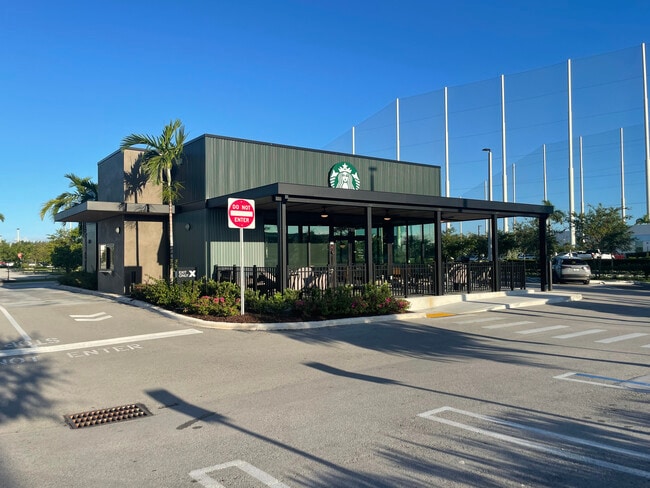
1780 Nw 117Th Pl
Miami-Miami Beach-Kendall, FL
Beacon Lakes Expansion North
25-3936-009-0020
BEACON LAKES EXPANSION NORTH PB 173-100 T-24141 PORT OF TR A BEG 10FTS OF NELY COR OF SD TR TH SELY AD 54.73FT SWLY AD 101.42FT W163.70FT N136.12FT E131.10FT TO POB LOT SIZE 21281 SQ FT M/L FAU 25-3936-009-0010
Restaurantdrivein
Miami/Dade
2024
Florida
2025
0.51 AC
014100
Outlying Miami-Dade Cnty
3,397 SF
South Florida
DEMOGRAPHICS near 1780 Nw 117Th Pl
1 Mile
3 Mile
5 Mile
2024 Total Population
1,243
123,783
300,573
2029 Population
1,198
120,173
294,241
Pop Growth 2024-2029
(3.62%)
(2.92%)
(2.11%)
Average Age
41
41
41
2024 Total Households
384
39,937
96,771
HH Growth 2024-2029
(4.17%)
(3.42%)
(2.46%)
Median Household Inc
$58,207
$61,182
$65,926
Avg Household Size
3.30
2.90
3.00
2024 Avg HH Vehicles
2.00
2.00
2.00
Median Home Value
$335,915
$340,895
$385,879
Median Year Built
1996
1987
1986
Nearby Places
Map Layers
Map Styles
 Street
 Aerial
- Restaurants
- Banks
- Shops
- Fitness
- Groceries
PUBLIC TRANSPORTATION
COMMUTER RAIL
Palmetto (Metrorail Green Line - Miami-Dade Transit (Metrorail/Metromover))
DRIVE
WALK
Distance
Palmetto (Metrorail Green Line - Miami-Dade Transit (Metrorail/Metromover))
15 min
7.5 mi
Okeechobee (Metrorail Green Line - Miami-Dade Transit (Metrorail/Metromover))
DRIVE
WALK
Distance
Okeechobee (Metrorail Green Line - Miami-Dade Transit (Metrorail/Metromover))
17 min
9.2 mi
AIRPORT
Miami International
DRIVE
WALK
Distance
Miami International
15 min
6.7 mi
Fort Lauderdale/Hollywood International
DRIVE
WALK
Distance
Fort Lauderdale/Hollywood International
42 min
31.4 mi
Freight Ports
Port of Miami
DRIVE
WALK
Distance
Port of Miami
28 min
16.7 mi
Nearby Properties
Address
Land Use
TOTAL SIZE
Lot Size
Zoning
Address
Land Use
TOTAL SIZE
Lot Size
Zoning
2,512,642 SF
100.78 AC
6400
Address
Land Use
TOTAL SIZE
Lot Size
Zoning
4,384,261 SF
343.66 AC
6400
Address
Land Use
TOTAL SIZE
Lot Size
Zoning
1,071,874 SF
6.73 AC
4802
Address
Land Use
TOTAL SIZE
Lot Size
Zoning
784,416 SF
1.72 AC
6480
Address
Land Use
TOTAL SIZE
Lot Size
Zoning
1,680,493 SF
23.71 AC
4100
Address
Land Use
TOTAL SIZE
Lot Size
Zoning
585,943 SF
22.41 AC
3800
Address
Land Use
TOTAL SIZE
Lot Size
Zoning
475,423 SF
14.56 AC
9450
Address
Land Use
TOTAL SIZE
Lot Size
Zoning
899,162 SF
9.89 AC
7700
Address
Land Use
TOTAL SIZE
Lot Size
Zoning
448,531 SF
37 AC
6400
Address
Land Use
TOTAL SIZE
Lot Size
Zoning
868,154 SF
1.71 AC
6480
Address
Land Use
TOTAL SIZE
Lot Size
Zoning
540,427 SF
26.86 AC
3700
Address
Land Use
TOTAL SIZE
Lot Size
Zoning
762,624 SF
1.70 AC
6480
Address
Land Use
TOTAL SIZE
Lot Size
Zoning
145.77 AC
7700
Address
Land Use
TOTAL SIZE
Lot Size
Zoning
755,156 SF
29.44 AC
7100
Address
Land Use
TOTAL SIZE
Lot Size
Zoning
438,387 SF
16.20 AC
3900
Address
Land Use
TOTAL SIZE
Lot Size
Zoning
359,107 SF
9.58 AC
9450
Address
Land Use
TOTAL SIZE
Lot Size
Zoning
428,212 SF
17.56 AC
3900
Address
Land Use
TOTAL SIZE
Lot Size
Zoning
468,411 SF
21.36 AC
7100
Address
Land Use
TOTAL SIZE
Lot Size
Zoning
206,535 SF
7100
Address
Land Use
TOTAL SIZE
Lot Size
Zoning
476,094 SF
1.09 AC
6480
Address
Land Use
TOTAL SIZE
Lot Size
Zoning
229,154 SF
9.02 AC
3900
Address
Land Use
TOTAL SIZE
Lot Size
Zoning
298,603 SF
24.12 AC
7100
Address
Land Use
TOTAL SIZE
Lot Size
Zoning
318,775 SF
18.88 AC
3700
Address
Land Use
TOTAL SIZE
Lot Size
Zoning
1,182,342 SF
14.60 AC
7100
Address
Land Use
TOTAL SIZE
Lot Size
Zoning
301,695 SF
17.60 AC
3700
Address
Land Use
TOTAL SIZE
Lot Size
Zoning
477,987 SF
26.98 AC
7100
Address
Land Use
TOTAL SIZE
Lot Size
Zoning
267,129 SF
16.55 AC
3800
Address
Land Use
TOTAL SIZE
Lot Size
Zoning
318,842 SF
22.14 AC
7100
Address
Land Use
TOTAL SIZE
Lot Size
Zoning
14,889 SF
70.12 AC
7100
The World's #1 Commercial Real Estate Marketplace
Connect with us
© 2025 CoStar Group
The information above has been obtained from sources believed reliable. While we do not doubt its accuracy we have not verified it and make no guarantee, warranty or representation about it. It is your responsibility to independently confirm its accuracy and completeness. Any projections, opinions, assumptions, or estimates used are for example only and do not represent the current or future performance of the property. The value of this transaction to you depends on tax and other factors which should be evaluated by your tax, financial, and legal advisors. You and your advisors should conduct a careful, independent investigation of the property to determine to your satisfaction the suitability of the property for your needs.