Property Record
1781 Jones Way, Oxnard, CA 93033
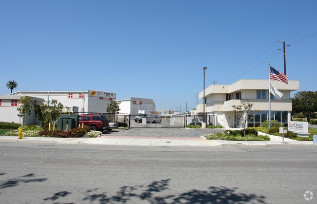

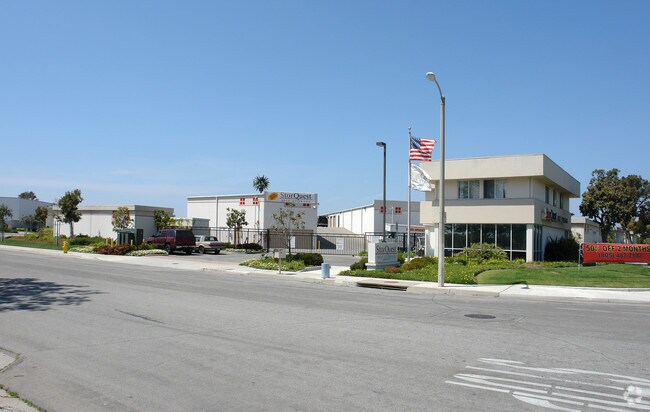
Property Detail
1781 Jones Way
220-0-273-055
TRACT: 406501 LOT: 34 REF: 102MR 60
Publicstorage
Ventura
MLPD
California
C and X Area of minimal flood hazard, usually depicted on FIRMs as above the 500-year flood level.
34
2024
3.16 AC
2025
Oxnard/Port Hueneme
009100
Los Angeles
80,002 SF
Oxnard-Thousand Oaks-Ventura, CA
NEARBY LISTINGS FOR SALE OR LEASE
-
-
View all Oxnard listings for sale on LoopNet.com
DEMOGRAPHICS near 1781 Jones Way
1 mile
3 mile
5 mile
2025 Total Population
20,034
154,298
231,858
2030 Population
19,699
152,464
230,269
Pop Growth 2025-2030
(1.67%)
(1.19%)
(0.69%)
Average Age
36
36
37
2025 Total Households
4,309
37,858
63,922
HH Growth 2025-2030
(1.95%)
(1.26%)
(0.47%)
Median Household Inc
$91,970
$86,997
$92,988
Avg Household Size
4.30
3.80
3.40
2025 Avg HH Vehicles
3.00
2.00
2.00
Median Home Value
$642,956
$658,458
$707,090
Median Year Built
1969
1971
1975
Nearby Places
Map Layers
Map Styles
 Street
 Aerial
Layers
 Traffic
 Biking
Places
Listings with unknown addresses are not visible on the map
- Restaurants
- Banks
- Shops
- Fitness
- Groceries
PUBLIC TRANSPORTATION
COMMUTER RAIL
Oxnard (Ventura County Line - Southern California Regional Rail Authority (Metrolink))
Drive
Walk
Distance
Oxnard (Ventura County Line - Southern California Regional Rail Authority (Metrolink))
4 min
2.3 mi
East Ventura Metrolink Station (Metrolink Ventura County Line - Metrolink Trains)
Drive
Walk
Distance
East Ventura Metrolink Station (Metrolink Ventura County Line - Metrolink Trains)
12 min
6.7 mi
Freight Ports
The Port of Hueneme
Drive
Walk
Distance
The Port of Hueneme
8 min
4.0 mi
Nearby Properties
Address
Land Use
TOTAL SIZE
Lot Size
Zoning
Address
Land Use
TOTAL SIZE
Lot Size
Zoning
135,631 SF
74.32 AC
Address
Land Use
TOTAL SIZE
Lot Size
Zoning
25.09 AC
Address
Land Use
TOTAL SIZE
Lot Size
Zoning
35.90 AC
BRP
Address
Land Use
TOTAL SIZE
Lot Size
Zoning
31.75 AC
Address
Land Use
TOTAL SIZE
Lot Size
Zoning
505,728 SF
20.81 AC
Address
Land Use
TOTAL SIZE
Lot Size
Zoning
15.09 AC
Address
Land Use
TOTAL SIZE
Lot Size
Zoning
90,086 SF
10.48 AC
CDI
Address
Land Use
TOTAL SIZE
Lot Size
Zoning
352,898 SF
16.57 AC
ML
Address
Land Use
TOTAL SIZE
Lot Size
Zoning
11.28 AC
CMPD
Address
Land Use
TOTAL SIZE
Lot Size
Zoning
30,800 SF
32.79 AC
M-1-
Address
Land Use
TOTAL SIZE
Lot Size
Zoning
15.59 AC
Address
Land Use
TOTAL SIZE
Lot Size
Zoning
8,398 SF
45.88 AC
M1PD
Address
Land Use
TOTAL SIZE
Lot Size
Zoning
70,392 SF
19.97 AC
4
Address
Land Use
TOTAL SIZE
Lot Size
Zoning
158,736 SF
6.33 AC
Address
Land Use
TOTAL SIZE
Lot Size
Zoning
129,018 SF
5.09 AC
R3PD
Address
Land Use
TOTAL SIZE
Lot Size
Zoning
133,174 SF
5.94 AC
R3PD
Address
Land Use
TOTAL SIZE
Lot Size
Zoning
770 SF
9.80 AC
M1
Address
Land Use
TOTAL SIZE
Lot Size
Zoning
157,108 SF
21.40 AC
MULT
Address
Land Use
TOTAL SIZE
Lot Size
Zoning
20,349 SF
9.65 AC
C2
Address
Land Use
TOTAL SIZE
Lot Size
Zoning
72,335 SF
10.67 AC
Address
Land Use
TOTAL SIZE
Lot Size
Zoning
390 SF
39.49 AC
Address
Land Use
TOTAL SIZE
Lot Size
Zoning
0.75 AC
BRP
Address
Land Use
TOTAL SIZE
Lot Size
Zoning
7.95 AC
M2
Address
Land Use
TOTAL SIZE
Lot Size
Zoning
81,233 SF
3.29 AC
R3PD
Address
Land Use
TOTAL SIZE
Lot Size
Zoning
79,117 SF
3.25 AC
R3PD
Address
Land Use
TOTAL SIZE
Lot Size
Zoning
60,496 SF
4.17 AC
R4PD
Address
Land Use
TOTAL SIZE
Lot Size
Zoning
106,404 SF
5.95 AC
ML
Address
Land Use
TOTAL SIZE
Lot Size
Zoning
17,185 SF
13.96 AC
RE1A
Address
Land Use
TOTAL SIZE
Lot Size
Zoning
6,279 SF
5.53 AC
M2PD
Address
Land Use
TOTAL SIZE
Lot Size
Zoning
51,694 SF
2.75 AC
The World's #1 Commercial Real Estate Marketplace
Connect with us
© 2026 CoStar Group
The information above has been obtained from sources believed reliable. While we do not doubt its accuracy we have not verified it and make no guarantee, warranty or representation about it. It is your responsibility to independently confirm its accuracy and completeness. Any projections, opinions, assumptions, or estimates used are for example only and do not represent the current or future performance of the property. The value of this transaction to you depends on tax and other factors which should be evaluated by your tax, financial, and legal advisors. You and your advisors should conduct a careful, independent investigation of the property to determine to your satisfaction the suitability of the property for your needs.