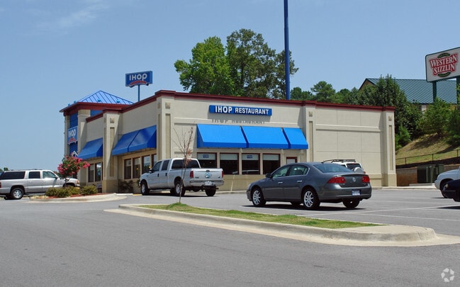
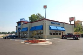
Property Record
17821 Interstate 30 S, Benton, AR 72015

Property Detail
17821 Interstate 30 S
805-15043-000
PT FRL SWNE 2016-001679
Restaurantbuilding
Saline
B and X Area of moderate flood hazard, usually the area between the limits of the 100-year and 500-year floods.
Arkansas
2025
1.30 AC
2025
Saline County
010101
Little Rock/N Little Rock
5,228 SF
Little Rock-North Little Rock-Conway, AR
NEARBY LISTINGS FOR SALE OR LEASE
DEMOGRAPHICS near 17821 Interstate 30 S
1 mile
3 mile
5 mile
2025 Total Population
5,863
35,973
56,316
2030 Population
6,138
37,796
59,149
Pop Growth 2025-2030
+ 4.69%
+ 5.07%
+ 5.03%
Average Age
39
39
39
2025 Total Households
2,336
14,283
22,396
HH Growth 2025-2030
+ 4.79%
+ 5.15%
+ 5.07%
Median Household Inc
$71,260
$70,160
$72,680
Avg Household Size
2.50
2.50
2.50
2025 Avg HH Vehicles
2.00
2.00
2.00
Median Home Value
$206,407
$216,199
$234,711
Median Year Built
1982
1991
1994
Nearby Places
Map Layers
Map Styles
 Street
 Aerial
Layers
 Traffic
 Biking
Places
Listings with unknown addresses are not visible on the map
- Restaurants
- Banks
- Shops
- Fitness
- Groceries
PUBLIC TRANSPORTATION
AIRPORT
Bill and Hillary Clinton Ntl/Adams Field
Drive
Walk
Distance
Bill and Hillary Clinton Ntl/Adams Field
29 min
24.0 mi
Freight Ports
Port of Shreveport
Drive
Walk
Distance
Port of Shreveport
227 min
212.2 mi
Nearby Properties
Address
Land Use
TOTAL SIZE
Lot Size
Zoning
Address
Land Use
TOTAL SIZE
Lot Size
Zoning
32,067 SF
26.67 AC
Address
Land Use
TOTAL SIZE
Lot Size
Zoning
297,680 SF
16.96 AC
Address
Land Use
TOTAL SIZE
Lot Size
Zoning
175,840 SF
21.93 AC
Address
Land Use
TOTAL SIZE
Lot Size
Zoning
106,096 SF
9.46 AC
Address
Land Use
TOTAL SIZE
Lot Size
Zoning
36,979 SF
7.85 AC
Address
Land Use
TOTAL SIZE
Lot Size
Zoning
137,445 SF
28.75 AC
Address
Land Use
TOTAL SIZE
Lot Size
Zoning
98,702 SF
0.67 AC
Address
Land Use
TOTAL SIZE
Lot Size
Zoning
75,795 SF
9.39 AC
Address
Land Use
TOTAL SIZE
Lot Size
Zoning
128,225 SF
8.41 AC
Address
Land Use
TOTAL SIZE
Lot Size
Zoning
90,200 SF
17.30 AC
Address
Land Use
TOTAL SIZE
Lot Size
Zoning
60,030 SF
6.51 AC
Address
Land Use
TOTAL SIZE
Lot Size
Zoning
43,055 SF
3.94 AC
Address
Land Use
TOTAL SIZE
Lot Size
Zoning
54,681 SF
1.88 AC
Address
Land Use
TOTAL SIZE
Lot Size
Zoning
78,845 SF
15.44 AC
Address
Land Use
TOTAL SIZE
Lot Size
Zoning
27,288 SF
4.02 AC
Address
Land Use
TOTAL SIZE
Lot Size
Zoning
63,870 SF
7.97 AC
Address
Land Use
TOTAL SIZE
Lot Size
Zoning
44,100 SF
3.52 AC
Address
Land Use
TOTAL SIZE
Lot Size
Zoning
12,354 SF
6.35 AC
Address
Land Use
TOTAL SIZE
Lot Size
Zoning
99,812 SF
11.36 AC
Address
Land Use
TOTAL SIZE
Lot Size
Zoning
47,958 SF
1.54 AC
Address
Land Use
TOTAL SIZE
Lot Size
Zoning
18,720 SF
9.49 AC
Address
Land Use
TOTAL SIZE
Lot Size
Zoning
9,304 SF
7.48 AC
Address
Land Use
TOTAL SIZE
Lot Size
Zoning
7,236 SF
17.93 AC
Address
Land Use
TOTAL SIZE
Lot Size
Zoning
10,211 SF
12.73 AC
Address
Land Use
TOTAL SIZE
Lot Size
Zoning
92,420 SF
11.55 AC
Address
Land Use
TOTAL SIZE
Lot Size
Zoning
68,190 SF
4.43 AC
Address
Land Use
TOTAL SIZE
Lot Size
Zoning
190,100 SF
215.53 AC
Address
Land Use
TOTAL SIZE
Lot Size
Zoning
14,760 SF
2.55 AC
Address
Land Use
TOTAL SIZE
Lot Size
Zoning
19,265 SF
2.06 AC
Address
Land Use
TOTAL SIZE
Lot Size
Zoning
40,650 SF
5.88 AC
The World's #1 Commercial Real Estate Marketplace
Connect with us
© 2026 CoStar Group
The information above has been obtained from sources believed reliable. While we do not doubt its accuracy we have not verified it and make no guarantee, warranty or representation about it. It is your responsibility to independently confirm its accuracy and completeness. Any projections, opinions, assumptions, or estimates used are for example only and do not represent the current or future performance of the property. The value of this transaction to you depends on tax and other factors which should be evaluated by your tax, financial, and legal advisors. You and your advisors should conduct a careful, independent investigation of the property to determine to your satisfaction the suitability of the property for your needs.