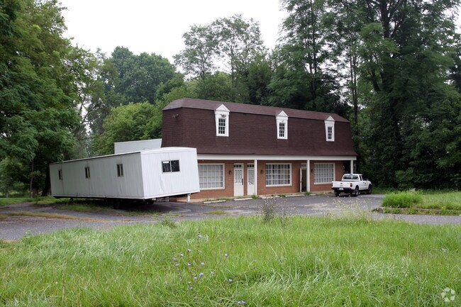
Property Record
17821 New Hampshire Ave, Ashton, MD 20861

NEARBY LISTINGS FOR SALE OR LEASE
Property Detail
17821 New Hampshire Ave
Washington-Arlington-Alexandria, DC-VA-MD-WV
Charley Forest
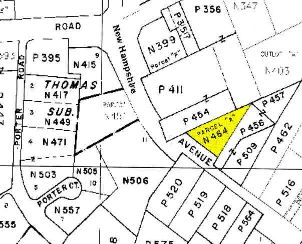
08-00701590
PAR A W A & A F BEHRENDT SUB
Hospitalpublic
Montgomery
X
Maryland
24027C0120D
a
0
0.44 AC
2025
Outlying Montgmery Cnty E
701316
Washington, DC
2,880 SF
DEMOGRAPHICS near 17821 New Hampshire Ave
1 Mile
3 Mile
5 Mile
2024 Total Population
2,200
22,668
98,679
2029 Population
2,211
22,455
97,721
Pop Growth 2024-2029
+ 0.50%
(0.94%)
(0.97%)
Average Age
44
43
45
2024 Total Households
733
7,584
35,833
HH Growth 2024-2029
+ 0.41%
(1.16%)
(1.04%)
Median Household Inc
$139,102
$148,720
$128,731
Avg Household Size
2.80
2.90
2.70
2024 Avg HH Vehicles
2.00
2.00
2.00
Median Home Value
$771,671
$691,362
$602,018
Median Year Built
1987
1987
1983
Nearby Places
Map Layers
Map Styles
 Street
 Aerial
- Restaurants
- Banks
- Shops
- Fitness
- Groceries
PUBLIC TRANSPORTATION
COMMUTER RAIL
Rockville (Brunswick Line - Maryland Area Regional Commuter Trains (The MARC))
DRIVE
WALK
Distance
Rockville (Brunswick Line - Maryland Area Regional Commuter Trains (The MARC))
19 min
9.9 mi
AIRPORT
Ronald Reagan Washington Ntl
DRIVE
WALK
Distance
Ronald Reagan Washington Ntl
41 min
23.8 mi
Baltimore/Washington International Thurgood Marshall
DRIVE
WALK
Distance
Baltimore/Washington International Thurgood Marshall
38 min
25.3 mi
Washington Dulles International
DRIVE
WALK
Distance
Washington Dulles International
62 min
37.9 mi
Freight Ports
Port of Baltimore
DRIVE
WALK
Distance
Port of Baltimore
41 min
28.0 mi
Nearby Properties
Address
Land Use
TOTAL SIZE
Lot Size
Zoning
Address
Land Use
TOTAL SIZE
Lot Size
Zoning
233,735 SF
21.74 AC
RE2
Address
Land Use
TOTAL SIZE
Lot Size
Zoning
202,044 SF
17.69 AC
CRT2.
Address
Land Use
TOTAL SIZE
Lot Size
Zoning
251,862 SF
91.09 AC
RE2C
Address
Land Use
TOTAL SIZE
Lot Size
Zoning
235,762 SF
139.24 AC
RE2
Address
Land Use
TOTAL SIZE
Lot Size
Zoning
289,712 SF
19.79 AC
RNC
Address
Land Use
TOTAL SIZE
Lot Size
Zoning
135,878 SF
17.11 AC
RNC
Address
Land Use
TOTAL SIZE
Lot Size
Zoning
165,842 SF
16.90 AC
RE2
Address
Land Use
TOTAL SIZE
Lot Size
Zoning
209,897 SF
48.45 AC
RC
Address
Land Use
TOTAL SIZE
Lot Size
Zoning
96,941 SF
10.87 AC
CRT2.
Address
Land Use
TOTAL SIZE
Lot Size
Zoning
140,080 SF
6.48 AC
PD9
Address
Land Use
TOTAL SIZE
Lot Size
Zoning
143,000 SF
20.01 AC
RC
Address
Land Use
TOTAL SIZE
Lot Size
Zoning
61,578 SF
4.80 AC
RE2
Address
Land Use
TOTAL SIZE
Lot Size
Zoning
110,210 SF
3.92 AC
CRT2.
Address
Land Use
TOTAL SIZE
Lot Size
Zoning
124,099 SF
10.95 AC
RE2
Address
Land Use
TOTAL SIZE
Lot Size
Zoning
34,658 SF
2.99 AC
CRT2.
Address
Land Use
TOTAL SIZE
Lot Size
Zoning
53,664 SF
17.63 AC
R90
Address
Land Use
TOTAL SIZE
Lot Size
Zoning
61,508 SF
10.05 AC
RE1
Address
Land Use
TOTAL SIZE
Lot Size
Zoning
67,999 SF
12.67 AC
RE2
Address
Land Use
TOTAL SIZE
Lot Size
Zoning
68,190 SF
3.29 AC
CRT2.
Address
Land Use
TOTAL SIZE
Lot Size
Zoning
51,824 SF
10.49 AC
PCC
Address
Land Use
TOTAL SIZE
Lot Size
Zoning
63,992 SF
37.97 AC
RC
Address
Land Use
TOTAL SIZE
Lot Size
Zoning
55,972 SF
49.25 AC
Address
Land Use
TOTAL SIZE
Lot Size
Zoning
57,793 SF
10.85 AC
RE2
Address
Land Use
TOTAL SIZE
Lot Size
Zoning
90,759 SF
5.45 AC
RE2
Address
Land Use
TOTAL SIZE
Lot Size
Zoning
45,000 SF
3.63 AC
NR0.7
Address
Land Use
TOTAL SIZE
Lot Size
Zoning
78,736 SF
35.96 AC
RE2
Address
Land Use
TOTAL SIZE
Lot Size
Zoning
40,425 SF
7.02 AC
RE2C
Address
Land Use
TOTAL SIZE
Lot Size
Zoning
48,750 SF
3.94 AC
RE2
Address
Land Use
TOTAL SIZE
Lot Size
Zoning
2,275 SF
78.18 AC
RC
Address
Land Use
TOTAL SIZE
Lot Size
Zoning
35,412 SF
4.64 AC
RE2
The World's #1 Commercial Real Estate Marketplace
Connect with us
© 2025 CoStar Group
The information above has been obtained from sources believed reliable. While we do not doubt its accuracy we have not verified it and make no guarantee, warranty or representation about it. It is your responsibility to independently confirm its accuracy and completeness. Any projections, opinions, assumptions, or estimates used are for example only and do not represent the current or future performance of the property. The value of this transaction to you depends on tax and other factors which should be evaluated by your tax, financial, and legal advisors. You and your advisors should conduct a careful, independent investigation of the property to determine to your satisfaction the suitability of the property for your needs.