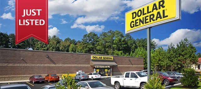
Property Record
17830 Main St N, Blountstown, FL 32424
NEARBY LISTINGS FOR SALE OR LEASE
Property Detail
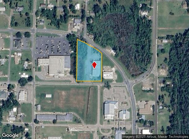
17830 Main St N
Storemultistory
BEG AT PT 240FT W ALG N BNDY OF EVANS ST FROM ITS INTERS W/ NLY PROJ OF W BNDY MAIN ST W 283FT N 200FT E 283FT S 250FT TO POB DB E-2-24, 73-43, OR 290-403 (PRO 2002-56) OR 403- 450 *ALSO: COM INTERS N R/W EVANS AVE & E R/W CHARLIE JOHN ST E ON N
X
Calhoun
12013C0210F
Florida
2025
2.38 AC
2025
Florida Panhandle Area
010301
Other Market Areas
12,480 SF
28-1N-08-0000-0083-0000
DEMOGRAPHICS near 17830 Main St N
1 Mile
3 Mile
5 Mile
2024 Total Population
1,820
5,401
7,301
2029 Population
1,876
5,572
7,415
Pop Growth 2024-2029
+ 3.08%
+ 3.17%
+ 1.56%
Average Age
41
42
42
2024 Total Households
629
1,647
2,330
HH Growth 2024-2029
+ 3.34%
+ 3.70%
+ 1.80%
Median Household Inc
$51,486
$41,703
$41,593
Avg Household Size
2.50
2.50
2.50
2024 Avg HH Vehicles
2.00
2.00
2.00
Median Home Value
$156,399
$159,999
$148,426
Median Year Built
1976
1978
1981
Nearby Places
Map Layers
Map Styles
 Street
 Aerial
- Restaurants
- Banks
- Shops
- Fitness
- Groceries
Nearby Properties
Address
Land Use
TOTAL SIZE
Lot Size
Zoning
Address
Land Use
TOTAL SIZE
Lot Size
Zoning
51,346 SF
3.96 AC
Address
Land Use
TOTAL SIZE
Lot Size
Zoning
108,214 SF
25.10 AC
Address
Land Use
TOTAL SIZE
Lot Size
Zoning
60,362 SF
25.21 AC
Address
Land Use
TOTAL SIZE
Lot Size
Zoning
54,665 SF
5.04 AC
Address
Land Use
TOTAL SIZE
Lot Size
Zoning
52,452 SF
1.49 AC
Address
Land Use
TOTAL SIZE
Lot Size
Zoning
28,077 SF
2.96 AC
Address
Land Use
TOTAL SIZE
Lot Size
Zoning
45,061 SF
3.03 AC
Address
Land Use
TOTAL SIZE
Lot Size
Zoning
10,640 SF
2.50 AC
Address
Land Use
TOTAL SIZE
Lot Size
Zoning
38,773 SF
3.50 AC
Address
Land Use
TOTAL SIZE
Lot Size
Zoning
7,612 SF
2.30 AC
Address
Land Use
TOTAL SIZE
Lot Size
Zoning
49,832 SF
5 AC
Address
Land Use
TOTAL SIZE
Lot Size
Zoning
33,086 SF
5.04 AC
Address
Land Use
TOTAL SIZE
Lot Size
Zoning
14,550 SF
20 AC
Address
Land Use
TOTAL SIZE
Lot Size
Zoning
16,503 SF
0.96 AC
Address
Land Use
TOTAL SIZE
Lot Size
Zoning
23,781 SF
141.41 AC
Address
Land Use
TOTAL SIZE
Lot Size
Zoning
9,090 SF
0.99 AC
Address
Land Use
TOTAL SIZE
Lot Size
Zoning
8,235 SF
2.28 AC
Address
Land Use
TOTAL SIZE
Lot Size
Zoning
32,153 SF
2.03 AC
Address
Land Use
TOTAL SIZE
Lot Size
Zoning
3,949 SF
1.67 AC
Address
Land Use
TOTAL SIZE
Lot Size
Zoning
28,658 SF
4.52 AC
Address
Land Use
TOTAL SIZE
Lot Size
Zoning
25,043 SF
3.83 AC
Address
Land Use
TOTAL SIZE
Lot Size
Zoning
25,896 SF
1.11 AC
Address
Land Use
TOTAL SIZE
Lot Size
Zoning
7,544 SF
1.31 AC
Address
Land Use
TOTAL SIZE
Lot Size
Zoning
31,460 SF
15 AC
Address
Land Use
TOTAL SIZE
Lot Size
Zoning
3,584 SF
1.46 AC
Address
Land Use
TOTAL SIZE
Lot Size
Zoning
14,288 SF
3.18 AC
Address
Land Use
TOTAL SIZE
Lot Size
Zoning
8,313 SF
5 AC
Address
Land Use
TOTAL SIZE
Lot Size
Zoning
7,011 SF
1.49 AC
Address
Land Use
TOTAL SIZE
Lot Size
Zoning
3,108 SF
0.81 AC
The World's #1 Commercial Real Estate Marketplace
Connect with us
© 2026 CoStar Group
The information above has been obtained from sources believed reliable. While we do not doubt its accuracy we have not verified it and make no guarantee, warranty or representation about it. It is your responsibility to independently confirm its accuracy and completeness. Any projections, opinions, assumptions, or estimates used are for example only and do not represent the current or future performance of the property. The value of this transaction to you depends on tax and other factors which should be evaluated by your tax, financial, and legal advisors. You and your advisors should conduct a careful, independent investigation of the property to determine to your satisfaction the suitability of the property for your needs.