Property Record
1784 Bryan Station Rd, Lexington, KY 40505
NEARBY LISTINGS FOR SALE OR LEASE
Property Detail
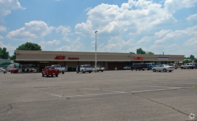
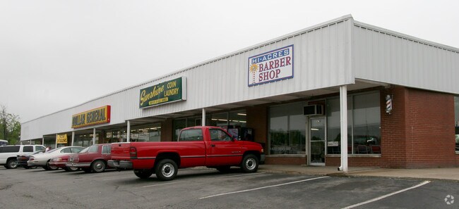
1784 Bryan Station Rd
Lexington-Fayette, KY
Hi Acres Shopping Center
38192890
N-554 HI ACRES SHOPPING CENTER LOT 2; BOOK: 3378 PAGE: 719
Stripcommercialcenter
Fayette
X
Kentucky
2100670129E
2
2025
1.02 AC
2025
East Lexington/Fayette
003202
Lexington/Fayette
17,640 SF
DEMOGRAPHICS near 1784 Bryan Station Rd
1 Mile
3 Mile
5 Mile
2024 Total Population
10,507
68,480
161,318
2029 Population
10,431
68,710
161,888
Pop Growth 2024-2029
(0.72%)
+ 0.34%
+ 0.35%
Average Age
41
39
37
2024 Total Households
4,421
29,915
69,066
HH Growth 2024-2029
(0.77%)
+ 0.39%
+ 0.38%
Median Household Inc
$51,754
$49,200
$53,927
Avg Household Size
2.30
2.10
2.20
2024 Avg HH Vehicles
2.00
2.00
2.00
Median Home Value
$149,816
$190,267
$243,145
Median Year Built
1965
1966
1977
Nearby Places
Map Layers
Map Styles
 Street
 Aerial
- Restaurants
- Banks
- Shops
- Fitness
- Groceries
PUBLIC TRANSPORTATION
AIRPORT
Blue Grass
DRIVE
WALK
Distance
Blue Grass
19 min
11.7 mi
Freight Ports
Port of Toledo
DRIVE
WALK
Distance
Port of Toledo
333 min
287.1 mi
SALE & LEASE HISTORY
LISTING DATE
SALE/LEASE

Sep 25, 2016
For Lease
Sep 01, 2020
For Lease
Nearby Properties
Address
Land Use
TOTAL SIZE
Lot Size
Zoning
Address
Land Use
TOTAL SIZE
Lot Size
Zoning
14.90 AC
B-2B
Address
Land Use
TOTAL SIZE
Lot Size
Zoning
1.25 AC
B-2B
Address
Land Use
TOTAL SIZE
Lot Size
Zoning
209,517 SF
39.97 AC
R-1B
Address
Land Use
TOTAL SIZE
Lot Size
Zoning
19 AC
R-3
Address
Land Use
TOTAL SIZE
Lot Size
Zoning
163,536 SF
117.26 AC
I-1
Address
Land Use
TOTAL SIZE
Lot Size
Zoning
292,191 SF
19.74 AC
B-5P
Address
Land Use
TOTAL SIZE
Lot Size
Zoning
24,174 SF
15.02 AC
R-3
Address
Land Use
TOTAL SIZE
Lot Size
Zoning
61,965 SF
46.96 AC
A-U
Address
Land Use
TOTAL SIZE
Lot Size
Zoning
278,944 SF
0.75 AC
B-2B
Address
Land Use
TOTAL SIZE
Lot Size
Zoning
340,698 SF
B-2B
Address
Land Use
TOTAL SIZE
Lot Size
Zoning
0.42 AC
B-2B
Address
Land Use
TOTAL SIZE
Lot Size
Zoning
41.55 AC
ED
Address
Land Use
TOTAL SIZE
Lot Size
Zoning
70.44 AC
I-1
Address
Land Use
TOTAL SIZE
Lot Size
Zoning
357,373 SF
2.43 AC
B-2B
Address
Land Use
TOTAL SIZE
Lot Size
Zoning
374,910 SF
0.78 AC
B-2B
Address
Land Use
TOTAL SIZE
Lot Size
Zoning
103,445 SF
18.39 AC
A-U
Address
Land Use
TOTAL SIZE
Lot Size
Zoning
133,750 SF
1.13 AC
B-2B
Address
Land Use
TOTAL SIZE
Lot Size
Zoning
267,060 SF
65 AC
R-3
Address
Land Use
TOTAL SIZE
Lot Size
Zoning
94,835 SF
21.09 AC
A-U
Address
Land Use
TOTAL SIZE
Lot Size
Zoning
64,425 SF
7.56 AC
R-4
Address
Land Use
TOTAL SIZE
Lot Size
Zoning
54,525 SF
25.78 AC
P-2
Address
Land Use
TOTAL SIZE
Lot Size
Zoning
53,543 SF
9.78 AC
R-1C
Address
Land Use
TOTAL SIZE
Lot Size
Zoning
123,132 SF
6.81 AC
R-4
Address
Land Use
TOTAL SIZE
Lot Size
Zoning
39,672 SF
46.50 AC
R-1B
Address
Land Use
TOTAL SIZE
Lot Size
Zoning
164,858 SF
0.18 AC
B-2B
Address
Land Use
TOTAL SIZE
Lot Size
Zoning
407,736 SF
29.54 AC
P-1
Address
Land Use
TOTAL SIZE
Lot Size
Zoning
12,048 SF
4.25 AC
B-2A
Address
Land Use
TOTAL SIZE
Lot Size
Zoning
210,498 SF
18.36 AC
I-1
Address
Land Use
TOTAL SIZE
Lot Size
Zoning
7,794 SF
18.45 AC
R-3
Address
Land Use
TOTAL SIZE
Lot Size
Zoning
286,060 SF
P-2
The World's #1 Commercial Real Estate Marketplace
Connect with us
© 2025 CoStar Group
The information above has been obtained from sources believed reliable. While we do not doubt its accuracy we have not verified it and make no guarantee, warranty or representation about it. It is your responsibility to independently confirm its accuracy and completeness. Any projections, opinions, assumptions, or estimates used are for example only and do not represent the current or future performance of the property. The value of this transaction to you depends on tax and other factors which should be evaluated by your tax, financial, and legal advisors. You and your advisors should conduct a careful, independent investigation of the property to determine to your satisfaction the suitability of the property for your needs.